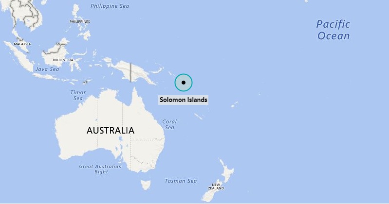
Where is Solomon Islands Located?
The given Solomon Islands location map shows that Solomon Islands is located in the South Pacific Ocean and to the east of Papua New Guinea and northwest of Vanuatu.
Solomon Island is archipelago of about thousands of islands. Its capital city is Honiara and it is located on the Guadalcanal Island – the largest island of Solomon Islands group. The nearest neighbors are Tuvalu lies in the east, Vanuatu in the south, Australia in the south-west, and Papua New Guinea in the west.
The government type of Solomon Islands is a constitutional monarchy featured with a parliamentary system of government. Queen Elizabeth II is the Monarch of the country as well as the head of state. Furthermore, she is represented by the Governor-General who is appointed by the Parliament for a five-year term. The Solomon Islands is a member of the Commonwealth of Nations.
The economy of the country largely depends upon agriculture and fishing. However, some of the natural resources available on the islands are lead, zinc, nickel, and gold.
List of Provinces and Capitals of Solomon Islands
| Rank | Province/Territory | Capital | Area (km2) | Population census 1999 |
|---|---|---|---|---|
| 1 | Central Province | Tulagi | 615 | 21,577 |
| 2 | Choiseul Province | Taro Island | 3,837 | 20,008 |
| 3 | Guadalcanal Province[1] | Honiara | 5,336 | 60,275 |
| 4 | Isabel Province | Buala | 4,136 | 20,421 |
| 5 | Makira-Ulawa Province | Kirakira | 3,188 | 31,006 |
| 6 | Malaita Province | Auki | 4,225 | 122,620 |
| 7 | Rennell and Bellona Province | Tigoa | 671 | 2,377 |
| 8 | Temotu Province | Lata | 895 | 18,912 |
| 9 | Western Province | Gizo | 5,475 | 62,739 |
| 10 | Capital Territory | Honiara | 22 | 49,107 |
Solomon Islands Geography & Facts
| Continent | Oceania |
| Location | South Pacific Ocean |
| Lat Long | Latitudes 5° and 13°S, and Longitudes 155° and 169°E |
| Islands | 6 major islands and over 900 smaller islands |
| Capitaland largest city | Honiara |
| Official languages | English |
| Ethnic groups | 95.3% Melanesian, 3.1% Polynesian, 1.2% Micronesian, 0.4% Others |
| Religion (2016) | 97.4% Christianity, 1.2% Folk religions, 1.4% Others |
| Demonym(s) | Solomon Islander |
| Government | Unitary parliamentary constitutional monarchy |
| Independence (From UK) | 7 July 1978 |
| Area | 28,400 km2 (11,000 sq mi) (139th) |
| • Water (%) | 3.20% |
| Population (2018 estimate) | 652,857 (167th) |
| • Density | 18.1/km2 (46.9/sq mi) (200th) |
| GDP (PPP) | 2019 estimate |
| GDP (PPP) (2019) | $1.479 billion[5] |
| Currency | Solomon Islands dollar (SBD) |
| Time zone | UTC+11 |
| Driving side | left |
| Calling code | 677 |
| ISO 3166 code | SB |
| Airport | Honiara International Airport (IATA: HIR, ICAO: AGGH) |
| Internet TLD | .sb |
- Where is American Samoa
- Where is Ashmore and Cartier Islands
- Where is Australia
- Where is Cook Islands
- Where is Coral Sea Islands
- Where is Federated States of Micronesia
- Where is Fiji
- Where is French Polynesia
- Where is Guam
- Where is Kiribati
- Where is Marshall Islands
- Where is Nauru
- Where is New Caledonia
- Where is New Zealand
- Where is Niue
- Where is Norfolk Island
- Where is Northern Mariana Islands
- Where is Palau
- Palmyra Atoll
- Papua New Guinea
- Where is Paracel Islands
- Where is Pitcairn Islands
- Where is Samoa
- Where is Solomon Islands
- Where is Tokelau
- Where is Tonga
- Where is Tuvalu
- Where is Vanuatu
- Where is Wake Island
- Where is Wallis and Futuna


