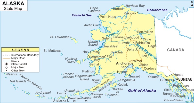
Alaska is the largest U.S. state by area 663,268 square miles (1,717,856 km2), and 48th most populous state of the 50 states of United States. The Alaska Map offers vital information on the exact location and diverse topography of the state. Alaska is located in the northwestern part of North America. According to the U.S. Census Bureau data of July 1, 2019, Alaska's population is 731,545. The state's capital is Juneau, which is prominently marked on the map, as are other important cities, Anchorange and Fairbanks. Alaska is politically sub-divided into 16 Boroughs for administrative purposes.
Map of Alaska with Cities, Road, River, Highways
 About Map: Alaska Map showing the capital, state boundary, roads, rail network,rivers, interstate highways, major cities and towns.
Most Viewed Links
About Alaska State Map
The Alaska State map depicts location of various cities, rivers, road and railway networks, counties and their respective seats, museums, and national parks. Covering the northwestern part of North America, Alaska spans over a total area of 663,268 sq. miles. The state is bordered by Canada on the east, the Beaufort Sea and Arctic Ocean in the north, the Bering Sea and has a maritime border with Russia in the west, and the Pacific Ocean and Gulf of Alaska in the south
Having an organized infrastructure of railways, roadways, and airways, Alaska is also accessible through waterways. The Alaska Map indicates the national and interstate highways. In addition, the railway map points out the prime train routes of the state. 11 census zones along with 16 boroughs collectively form the basis for the counties of Alaska. Tourists coming to Alaska can visit the well-maintained golf courses of the state such as Chena Bend, Sleepy Hollow, Eagleglen, and many more. The Kobuk Valley National Park, Yukon Charley Rivers National Preserve, and Katmai National Park & Preserve are some of the most visited national parks of Alaska. Museums are yet another major appeal of the state. Pratt Museum, Kodiak Baranov Museum, Alaska State Museum are some of the most popular. The Alaska State map, in a way, presents an illustrative overview of each aspect of the place.
Geographical Statistics:
Alaska Routes
The various areas of Alaska are well-connected with good roads, which are highlighted on the Alaska State Map. The northern and southern parts of Alaska are interconnected by State Roads 3, 4, 7, 9 and 11. State Roads 1, 2, 5, 6, 8, and 10 connect the eastern and western sides of the state. The Kebuk, Kuskokwim, Noatak, Yukon, Sustina, Tanana and Colville Rivers are the state's major streams.
State roads include: State Road 1, State Road 2, State Road 3, State Road 4, State Road 5, State Road 6, State Road 7, State Road 8, State Road 9, State Road 10 and State Road 11.
Alaska State Facts
| State Name | Alaska |
| Capital City | Juneau |
| Lagest City | Anchorage |
| Abbreviation | AK, US-AK |
| Joined The Union | January 3, 1959 (49th) |
| Nickname | The Last Frontier |
| Area | 663,268 sq mi (1,717,854 km2) |
| Timezone | AKST-Alaska Standard Time (UTC−09:00) |
| Population | 735,132 (2013 est) |
| Highest Point | Mount McKinley |
| Lowest Point | Ocean |
| Official Website | www.alaska.gov |
- Where is Akron
- Where is Anaheim
- Where is Anchorage
- Where is Arlington
- Where is Aurora
- Where is Baltimore
- Where is Baton Rouge
- Where is Birmingham
- Where is Boise City
- Where is Boston
- Where is Buffalo
- Where is Chandler
- Where is Charlotte
- Where is Chesapeake
- Where is Chula Vista
- Where is Cincinnati
- Where is Cleveland
- Where is Colorado Springs
- Where is Columbus
- Where is Corpus Christi
- Where is Des Moines
- Where is Detroit
- Where is Durham
- Where is El Paso
- Where is Fayetteville
- Where is Fort Wayne
- Where is Freemont
- Where is Fresno
- Where is Garland
- Where is Gilbert
- Where is Glendale
- Where is Greensboro
- Where is Henderson
- Where is Hialeah
- Where is Honolulu
- Where is Houston
- Where is Indianapolis
- Where is Irvine
- Where is Irving
- Where is Jacksonville
- Where is Jersey City
- Where is Kansas City
- Where is Laredo
- Where is Lincoln
- Where is Long Beach
- Where is Louisville
- Where is Lubbock
- Where is Madison
- Where is Memphis
- Where is Mesa
- Where is Milwaukee
- Where is Minneapolis
- Where is Modesto
- Where is Montgomery
- Where is Nashville
- Where is Newark
- Where is Norfolk
- Where is North Las Vegas
- Where is Oakland
- Where is Oklahoma City
- Where is Omaha
- Where is Orlando
- Where is Paradise
- Where is Philadelphia
- Where is Phoenix
- Where is Portland
- Where is Raleigh
- Where is Reno
- Where is Richmond
- Where is Riverside
- Where is Rochester
- Where is Sacramento
- Where is Saint Paul
- Where is Saint Petersburg
- Where is San Bernardino
- Where is San Jose
- Where is Santa Ana
- Where is Scottsdale
- Where is Shreveport
- Where is Spokane
- Where is St Louis
- Where is Stockton
- Where is Tampa
- Where is Toledo
- Where is Tucson
- Where is Tulsa
- Where is Virginia Beach
- Where is Wichita
