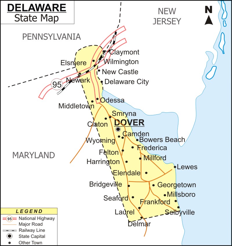
Delaware Map - The second-smallest state in the United States after Rhode Island. It is located in the Mid-Atlantic area of the U.S. Delaware is bordering by Maryland to the south and west, Pennsylvania to the north, and New Jersey and the Atlantic Ocean to the east.
Map of Delaware with Cities, Road, River, Highways
 About Map: Delaware Map showing the capital, state boundary, roads, rail network,rivers, interstate highways, major cities and towns.
Delaware More Maps & Info
About Delaware State Map
Delaware Map: Delaware is a state in the Mid-Atlantic area of the United States. The state is bordered by Maryland to the south and west, Pennsylvania to the north, New Jersey to the east, and the Atlantic Ocean to the west. The state is named from the nearby Delaware Bay, which was named after Thomas West, 3rd Baron De La Warr, an English nobleman and Virginia's first colonial governor. Delaware is located in the northeastern corner of the Delmarva Peninsula, as well as on a few islands and in certain areas of the Delaware River. Although it is the sixth-least populous and second-smallest state, it is also the sixth most densely populated. Wilmington is the largest city in Delaware, and Dover, the second-largest city, serves as the state's capital. Delaware Map shows these two cities as well as others.
Delaware Map
The detailed Delaware Map displays the boundaries of the state, the location of Dover, the state capital, as well as important cities and other populous areas, rivers and lakes, major highways, interstates, and railroads. You can download the Delaware Map that is provided on this page. It is free.
Delaware Map Shows the Major Cities
Delaware Map illustrates the major cities of the state such as Wilmington, Dover, Newark, Middletown, Smyrna, Milford, Seaford, Georgetown, Elsmere, Milford, Newark, Smyrna, Seaford, Lewes, Bridgeville, Claymont, New Castle, Delaware City, Odessa, Camden, Bowers Beach, Frederica, Millsboro, Frankford, Selbyville, Delmar, Ellendale, Harrington, Wyoming, and Claton. Delaware Map also indicates the geographical positions of the cities as well.
Delaware Map Indicates National Highways & Routes of the State:
Delaware Map shows all the National Highways and Routes that are part and parcel of the transport system of the State. North-South interstates include Interstate 15, Interstate 17 and Interstate 19. East-West interstates include Interstate 8, Interstate 10 and Interstate 40. US Highways and State Routes include Route 60, Route 70, Route 89, Route 89A, Route 93, Route 95, Route 160, Route 180 and Route 191.
Facts About Delaware
| State Name | Delaware |
| Country | United States |
| Continent | North America |
| Capital City | Dover |
| Lagest city | Wilmington |
| Abbreviation | DE, Del. US-DE |
| Joined the Union | December 7, 1787 (1st) |
| Nickname | The First State |
| area | 1,982 sq mi (6,452 km2) |
| Timezone | Eastern: UTC −5/−4 |
| Population | 917,092 (2012 est) |
| Highest Point | Near the Ebright Azimuth |
| Lowest Point | Atlantic Ocean sea level |
| Official Website | https://delaware.gov/ |
