
Written and Fact-checked by Whereig Editors | Last Updated On: June 17, 2026
Where is Tripoli Located on the Libya Map? Find Tripoli’s location map, coordinates, population, nearby cities, attractions, roads and highways, climate, transportation, and important city facts.
Location Map of Tripoli, Libya
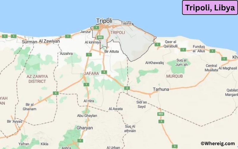
About Map: The map shows the location of Tripoli in the Libya.
Where is Tripoli Located?
Actually, the name Tripoli is a Greek word, which means "Three Cities"; however, in Arabic language it is Tarabulus. Initially, the city Tripoli was founded by Phoenicians, who named it Oea in the 7th Century BC.
By virtue of being historical site flavored with archaeological significance and in modern time most developed and having principal sea port, Tripoli is the largest commercial and manufacturing center of the country Libya.
The climate type of Tripoli is Mediterranean featured with hot, dry summers, cool and rainy winters.
Tripoli, Tripoli District Quick Facts
| Fact | Details |
|---|---|
| City | Tripoli |
| District | Tripoli District |
| Country | Libya |
| National Capital | Tripoli |
| Region | North Africa |
| Latitude | 32.8872° N |
| Longitude | 13.1913° E |
| Elevation | 266 ft (81 m) |
| Land Area | 154 sq mi |
| Water Area | Includes Mediterranean coastal waters and harbor areas |
| Total Area | 154 sq mi |
| Population (Latest Estimate) | Approximately 1.2 million |
| Population Density | Approximately 7,800 per sq mi |
| Postal Codes | Various postal zones within Tripoli Municipality |
| Area Code | +218 21 |
| Time Zone Standard | Eastern European Time (UTC+2) |
| Time Zone Daylight | No daylight saving time observed |
| Currency | Libyan Dinar (LYD) |
| Administrative Code | Tripoli Municipal Administration |
| National Representation | National Government and Administrative Institutions |
Nearby Cities to Tripoli, Libya
- Tajoura, Libya - 8 mi East
- Janzur, Libya - 8 mi West
- Qasr Bin Ghashir, Libya - 16 mi South
- Azizia, Libya - 25 mi Southwest
- Zawiya, Libya - 30 mi West
- Al Khums, Libya - 75 mi East
- Misrata, Libya - 125 mi East
- Gharyan, Libya - 60 mi South
- Sabratha, Libya - 43 mi West
- Zliten, Libya - 98 mi East
Tripoli, Libya Climate and Weather Overview
| Month | Avg High (°F) | Avg Low (°F) | Avg Rainfall (in) |
|---|---|---|---|
| January | 62 | 49 | 2.6 |
| April | 73 | 56 | 0.7 |
| July | 88 | 74 | 0.0 |
| October | 81 | 67 | 1.5 |
| Annual | 76 | 62 | 13.0 |
| Climate Attribute | Details |
|---|---|
| Climate Classification (Köppen) | Csa - Hot-Summer Mediterranean |
| Annual Rainfall | Approximately 13 inches |
| Annual Sunshine Days | More than 300 sunny days |
| Hurricane/Tornado Risk | Very Low |
| Snowfall | No snowfall |
Driving Distances from Tripoli, Libya
| City | Country | Distance (mi) | Approx. Drive Time |
|---|---|---|---|
| Tajoura | Libya | 8 | 15 min |
| Janzur | Libya | 8 | 15 min |
| Qasr Bin Ghashir | Libya | 16 | 25 min |
| Azizia | Libya | 25 | 35 min |
| Zawiya | Libya | 30 | 40 min |
| Sabratha | Libya | 43 | 55 min |
| Gharyan | Libya | 60 | 1 hr 15 min |
| Al Khums | Libya | 75 | 1 hr 20 min |
| Zliten | Libya | 98 | 1 hr 45 min |
| Misrata | Libya | 125 | 2 hr |
Transportation and Connectivity in Tripoli, Libya
| Airport Name | Mitiga International Airport |
| IATA Code | MJI |
| Port | Port of Tripoli |
| Major Highways | Libyan Coastal Highway, Airport Road, Tripoli Ring Roads |
| Train Service | No Active Passenger Rail Service |
| Local Transit Service | Public Buses, Shared Taxis and Private Transport |
- Libyan Coastal Highway - Main route connecting Tripoli with western and eastern coastal cities.
- Airport Road - Important corridor linking downtown Tripoli with Mitiga Airport.
- Tripoli Ring Roads - Serve traffic movement around the metropolitan area.
- Tripoli-Zawiya Highway - Connects the capital with major western districts.
- Tripoli-Misrata Highway - Key eastbound route along the Mediterranean coast.
Key Landmarks and Places to Visit in Tripoli, Libya
| Landmark Name | Type |
|---|---|
| Red Castle (Assaraya Alhamra) | Historic Fortress |
| Martyrs' Square | Public Square |
| Arch of Marcus Aurelius | Roman Monument |
| Tripoli Medina | Historic District |
| National Museum of Libya | Museum |
| Gurgi Mosque | Religious Site |
| Karamanli House Museum | Museum |
| Tripoli Harbor | Waterfront Area |
| Alger Square | Urban Landmark |
| Tripoli Zoo | Zoo |
Places to Visit in Tripoli, Libya
| Landmark Name | Type |
|---|---|
| Red Castle (Assaraya Alhamra) | Historic Fortress |
| Martyrs' Square | Public Square |
| Arch of Marcus Aurelius | Roman Monument |
| Tripoli Medina | Historic District |
| National Museum of Libya | Museum |
| Gurgi Mosque | Religious Site |
| Karamanli House Museum | Museum |
| Tripoli Harbor | Waterfront Area |
| Alger Square | Urban Landmark |
| Tripoli Zoo | Zoo |
Colleges and Universities in Tripoli, Libya
| Institution Name | Type | Level | Notable For |
|---|---|---|---|
| University of Tripoli | Public | University | Research and higher education |
| Libyan International Medical University | Private | University | Medical sciences |
| Open University of Libya | Public | University | Distance education |
| Higher Institute of Science and Technology | Public | College | Technical education |
| Tripoli Technical College | Public | College | Applied sciences |
Waterbodies in Tripoli, Libya
Mediterranean Sea, Tripoli Harbor, Kuwait Square Waterfront, Tajoura Coast, Janzur Coast, Wadi Al Majenin, Wadi Megenin Basin, Abu Sitta Bay, Tripoli Marina Waters, Western Coastal Lagoons
Golf Courses in Tripoli, Libya
Tripoli Golf Club, Green Mountain Golf Practice Facility, Mediterranean Golf Resort Tripoli, Janzur Golf Training Center, Tripoli Sports Club Golf Grounds
Tripoli, Libya - Key Historical Facts
- Tripoli was founded by the Phoenicians and later became an important city of the Roman Empire.
- The city served as a major Mediterranean trading center for centuries due to its strategic coastal location.
- Tripoli was ruled by various powers including the Arabs, Ottomans and Italians.
- Italian colonial development during the early twentieth century significantly influenced the city's architecture.
- Tripoli became the capital of independent Libya in 1951.
- Today, Tripoli remains Libya's largest city and principal center of government, commerce and culture.