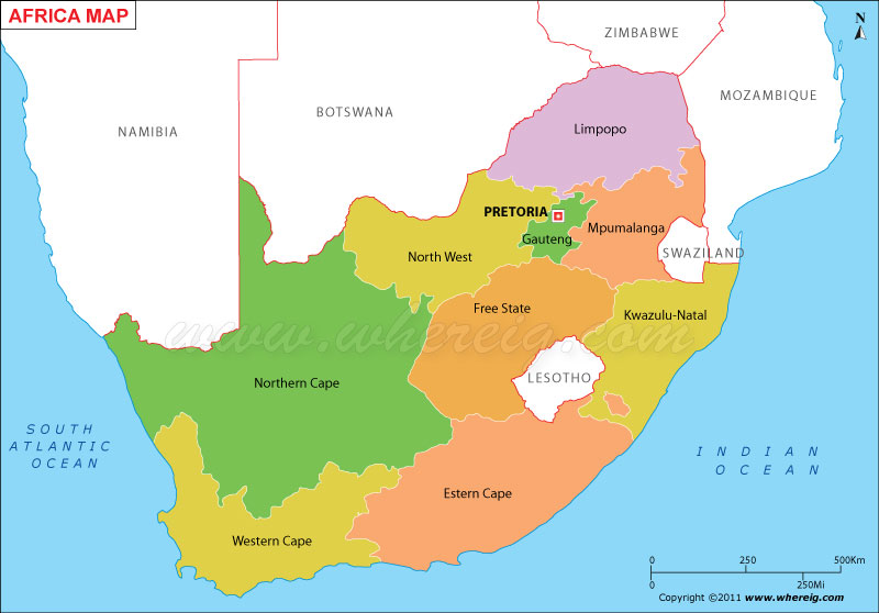
Description: The Political Map of South Africa showing South Africa States, cities, capital, international and state boundaries.
South Africa, officially the Republic of South Africa, is a country located in the southernmost region of Africa. the country lies between latitudes 22° and 35°S, and longitudes 16° and 33°E. Neighbouring countries of South africa is Namibia, Botswana and Zimbabwe in north; and Mozambique and Swaziland in south. Capital of South Africa is Pretoria (executive), Bloemfontein (judicial) and Cape Town (legislative).
Continent: Africa
Proviences: 9
Capital of South Africa: Pretoria (executive), Bloemfontein (judicial) and Cape Town (legislative)
South Africa official languages: Afrikaans, English, Ndebele, Northern Sotho, Sotho, Swazi, Tswana, Tsonga, Venda, Xhosa, and Zulu.
Legislature: Parliament
Area: 471,443 sq mi
Population: 50,586,757[4] (2011 Estimate)
Largest City: Johannesburg
Currency: Rand (ZAR)
Time zone: SAST (UTC+2)
Country Calling code: +27
| Where is Cape Town | Where is Durban | Where is South Africa |
| South Africa Map | South Africa Airports List | Where is Johannesburg |
About South Africa
Continent: Africa
Proviences: 9
Capital of South Africa: Pretoria (executive), Bloemfontein (judicial) and Cape Town (legislative)
South Africa official languages: Afrikaans, English, Ndebele, Northern Sotho, Sotho, Swazi, Tswana, Tsonga, Venda, Xhosa, and Zulu.
Legislature: Parliament
Area: 471,443 sq mi
Population: 50,586,757[4] (2011 Estimate)
Largest City: Johannesburg
Currency: Rand (ZAR)
Time zone: SAST (UTC+2)
Country Calling code: +27
- Where is Algeria
- Where is Angola
- Where is Benin
- Where is Botswana
- Where is Burkina Faso
- Where is Burundi
- Where is Cameroon
- Where is Canary Islands
- Where is Cape Verde
- Central African Republic
- Where is Ceuta
- Where is Chad
- Where is Cote d'Ivoire
- Where is Congo
- Where is Djibouti
- Where is Egypt
- Equatorial Guinea
- Where is Eritrea
- Where is Ethiopia
- Where is Gabon
- Where is Gambia
- Where is Ghana
- Where is Guinea
- Guinea Bissau
- Where is Kenya
- Where is Lesotho
- Where is Liberia
- Where is Libya
- Where is Madagascar
- Where is Madeira
- Where is Malawi
- Where is Mali
- Where is Mauritania
- Where is Mauritius
- Where is Mayotte
- Where is Melilla
- Where is Morocco
- Where is Mozambique
- Where is Namibia
- Where is Niger
- Where is Nigeria
- Republic of the Congo
- Where is Reunion
- Where is Rwanda
- Where is Saint Helena
- Sao Tome and Principe
- Where is Senegal
- Where is Seychelles
- Where is Sierra Leone
- Where is South Africa
- Where is Sudan
- Where is Swaziland
- Where is Tanzania
- Where is Togo
- Where is Tunisia
- Where is Uganda
- Where is Western Sahara
- Where is Zambia
- Where is Zimbabwe


