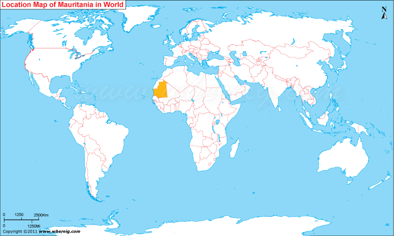
Where is Mauritania located on the world map? The given location map of Mauritania shows that Mauritania is located in the western part of Africa continent.
Mauritania map also depicts that the country shares its international boundaries with Western Sahara in the north, Algeria in the north-east, Mali in the east and south-east, and Senegal in the south-west. Besides, Atlantic Ocean borders it from the west. Nouakchott, located on the western coast is the largest and capital city of the country.
The government type of Mauritania is Islamic Republic.
Economy of the Mauritania is largely depends upon the agriculture, fishing, and livestock. Surprisingly, the region is very rich in terms of natural resources including huge deposits of iron ore (accounts about 50% of total exports), other important mining centers those are opening or about to open in the interior part of the country are metal prices, gold, and copper mining.
| Country | Mauritania |
| Continent | Africa |
| Where is Located | mauritania is a country located in the Lesser Antilles, Caribbean |
| Coordinates | 18.6597° N, 11.7001° W |
| Capital | Nouakchott |
| Largest City | Nouakchott |
| Neighboring Countries | None |
| Administrative divisions | None |
| Area | 1,030,700 sq km (397,954 sq miles) |
| Population | 3.542 million (2011 Census) |
| Official Language | Arabic, French |
| Currency | Ouguiya (MRO) |
| ISO Alpha-2 Code | MQ |
| ISO Alpha-3 Code | MTQ |
| ISO Numeric Code | 474 |
| GDP | $2,100 (2012 est.) |
| Calling code | 222 |
| Time Zone | (UTC+0) |
| Internet TLD | .mr |
- Where is Algeria
- Where is Angola
- Where is Benin
- Where is Botswana
- Where is Burkina Faso
- Where is Burundi
- Where is Cameroon
- Where is Canary Islands
- Where is Cape Verde
- Central African Republic
- Where is Ceuta
- Where is Chad
- Where is Cote d'Ivoire
- Where is Congo
- Where is Djibouti
- Where is Egypt
- Equatorial Guinea
- Where is Eritrea
- Where is Ethiopia
- Where is Gabon
- Where is Gambia
- Where is Ghana
- Where is Guinea
- Guinea Bissau
- Where is Kenya
- Where is Lesotho
- Where is Liberia
- Where is Libya
- Where is Madagascar
- Where is Madeira
- Where is Malawi
- Where is Mali
- Where is Mauritania
- Where is Mauritius
- Where is Mayotte
- Where is Morocco
- Where is Mozambique
- Where is Namibia
- Where is Niger
- Where is Nigeria
- Where is Congo
- Where is Reunion
- Where is Rwanda
- Where is Saint Helena
- Where is Sao Tome
- Where is Senegal
- Where is Seychelles
- Where is Sierra Leone
- Where is South Africa
- Where is Sudan
- Where is Swaziland
- Where is Tanzania
- Where is Togo
- Where is Tunisia
- Where is Uganda
- Where is Western Sahara
- Where is Zambia
- Where is Zimbabwe


