
The given Las Vegas location map shows that Las Vegas is located in the south-west of the United States and in the south of the state Nevada.
Location Map of Las Vegas
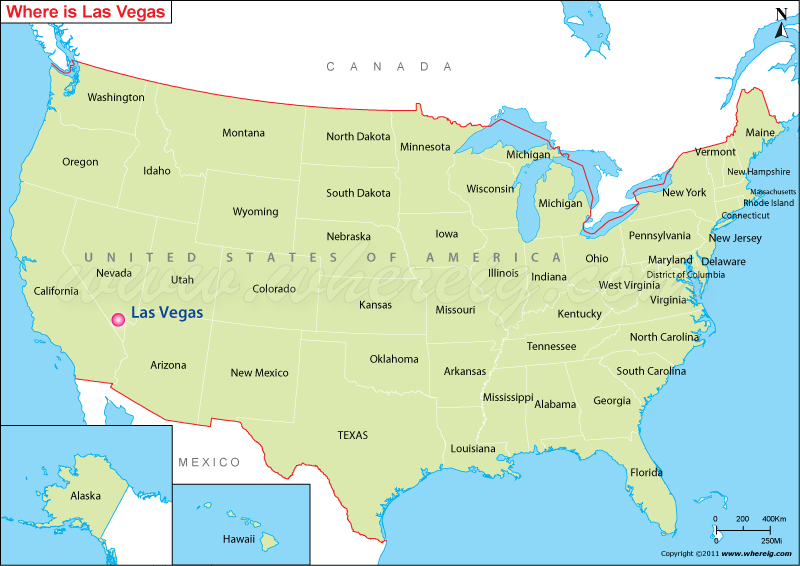
About Map: The Map showing Las Vegas location in the U.S. State of Nevada.
More Nevada Maps & Info
Where is Las Vegas?
Las Vegas, is the 28th-most populous city in the United States, seat of Clark county, located in the southeastern Nevada. Interestingly, Las Vegas is recognized as "The Entertainment Capital of the World" because it is an international major resort for gambling, shopping, and fine dining. Furthermore, due to city's tolerance for diverse forms of adult entertainment given the title of Sin City, and this image has made Las Vegas a popular setting for films and television programs. Above all, the most parts of the city have been adorned with various outdoor lighting displays on Fremont Street, as well as elsewhere in the city.
The city is established in the year 1905; however, it became a city in the year 1911 and since this time, the city has experienced manifold growth. Surprisingly, the name Las Vegas is often applied to unincorporated areas surrounding the city, more specifically the resort areas on and near the Las Vegas Strip.
Las Vegas, Nevada Quick Facts
| Fact | Details |
|---|---|
| City | Las Vegas |
| County | Clark County |
| State | Nevada |
| State Capital | Carson City |
| US Region | West |
| Latitude | 36.1699° N |
| Longitude | 115.1398° W |
| Elevation | 2,001 ft (610 m) |
| Land Area | 141.8 sq mi |
| Water Area | 0.2 sq mi |
| Total Area | 142.0 sq mi |
| Population (2020 Census) | 641,903 |
| Population Density | Approximately 4,527 per sq mi |
| ZIP Codes | 88901, 88905, 88915, 89101, 89102, 89103, 89104, 89106, 89107, 89108, 89109, 89110, 89113, 89115, 89117, 89118, 89119, 89120, 89121, 89122, 89123, 89124, 89128, 89129, 89130, 89131, 89134, 89135, 89138, 89139, 89141, 89142, 89143, 89144, 89145, 89146, 89147, 89148, 89149, 89156, 89161, 89166, 89169, 89178, 89179 |
| Area Code | 702, 725 |
| Time Zone Standard | Pacific Standard Time (PST, UTC-8) |
| Time Zone Daylight | Pacific Daylight Time (PDT, UTC-7) |
| Currency | US Dollar (USD) |
| FIPS Code | 32-40000 |
| Congressional District | Nevada 1st Congressional District |
Top Places to See in Las Vegas
| Bellagio Hotel and Casino | Fremont Street Experience | Sahara Las Vegas | El Cortez Hotel and Casino |
| Las Vegas Strip | Fountains of Bellagio | Shark Reef Aquarium at Mandalay Bay | Gold & Silver Pawn Shop |
| MGM Grand | The Neon Museum | The Mob Museum | Zak Bagans' The Haunted Museum |
| The STRAT Hotel, Casino & SkyPod | Fremont Street | Springs Preserve | The D Casino & Hotel |
| Luxor Hotel & Casino | The Adventuredome Indoor Theme Park | Discovery Children's Museum | Palace Station Hotel and Casino |
| Red Rock Canyon National | Golden Nugget Las Vegas Hotel | Four Queens | Nevada State Museum, Las Vegas |
| The Mirage | Treasure Island | SlotZilla Zipline | Las Vegas Mini Grand Prix Family |
| New York-New York Hotel & Casino | SkyJump Powered by MTN Dew | Plaza Hotel & Casino | Red Rock Canyon Visitor Center |
Location and Surroundings
Las Vegas is located in Clark County in southern Nevada within the Mojave Desert. It lies about 270 miles northeast of Los Angeles and is surrounded by mountain ranges and desert landscapes. The city is internationally known for entertainment, tourism, gaming, conventions, and luxury resorts.
Nearby Cities to Las Vegas, Nevada
- North Las Vegas, Nevada - 5 mi North
- Paradise, Nevada - 4 mi Southeast
- Winchester, Nevada - 3 mi East
- Spring Valley, Nevada - 7 mi West
- Sunrise Manor, Nevada - 8 mi East
- Enterprise, Nevada - 10 mi South
- Henderson, Nevada - 16 mi Southeast
- Boulder City, Nevada - 26 mi Southeast
- Mesquite, Nevada - 80 mi Northeast
- Pahrump, Nevada - 62 mi West
Las Vegas, Nevada Climate and Weather Overview
| Month | Avg High (°F) | Avg Low (°F) | Avg Rainfall (in) |
|---|---|---|---|
| January | 58 | 39 | 0.5 |
| April | 80 | 56 | 0.2 |
| July | 104 | 81 | 0.4 |
| October | 82 | 59 | 0.3 |
| Annual | 81 | 59 | 4.2 |
| Climate Attribute | Details |
|---|---|
| Climate Classification (Köppen) | Hot Desert (BWh) |
| Annual Rainfall | About 4.2 inches |
| Annual Sunshine Days | Approximately 294 days |
| Hurricane/Tornado Risk | Very low hurricane and tornado risk |
| Snowfall | Rare, less than 1 inch annually |
Driving Distances from Las Vegas, Nevada
| City | State | Distance (mi) | Approx. Drive Time |
|---|---|---|---|
| Paradise | Nevada | 4 | 10 min |
| North Las Vegas | Nevada | 5 | 10 min |
| Spring Valley | Nevada | 7 | 15 min |
| Sunrise Manor | Nevada | 8 | 15 min |
| Enterprise | Nevada | 10 | 20 min |
| Henderson | Nevada | 16 | 25 min |
| Boulder City | Nevada | 26 | 35 min |
| Pahrump | Nevada | 62 | 1 hr 10 min |
| Mesquite | Nevada | 80 | 1 hr 20 min |
| Kingman | Arizona | 107 | 1 hr 45 min |
Transportation and Connectivity in Las Vegas, Nevada
| Category | Details |
|---|---|
| Airport Name | Harry Reid International Airport |
| IATA Code | LAS |
| Port | Not Applicable |
| Major Highways | I-15, I-11, US 93, US 95, SR 160 |
| Train/Amtrak Service | No direct Amtrak service; connections available via regional bus links |
| Local Bus/Transit Service | RTC Southern Nevada Bus System |
- Interstate 15 - Connects Las Vegas with Los Angeles, Salt Lake City, and Southern California.
- Interstate 11 - Links Las Vegas with Henderson and the Phoenix corridor.
- US Highway 95 - Major north-south route serving Nevada communities.
- US Highway 93 - Connects the city with Arizona and northern Nevada.
- State Route 160 - Provides access to Pahrump and western desert communities.
Key Landmarks and Places to Visit in Las Vegas, Nevada
| Landmark Name | Type |
|---|---|
| Las Vegas Strip | Entertainment District |
| Fremont Street Experience | Entertainment Attraction |
| Bellagio Fountains | Landmark Attraction |
| Red Rock Canyon National Conservation Area | Natural Attraction |
| The Neon Museum | Museum |
| Mob Museum | Museum |
| High Roller Observation Wheel | Observation Attraction |
| Hoover Dam | Historic Landmark |
| AREA15 | Entertainment Complex |
| Shark Reef Aquarium | Aquarium |
Waterbodies in Las Vegas, Nevada
Lake Mead, Colorado River, Las Vegas Wash, Lake Las Vegas, Boulder Basin, Callville Bay, Black Canyon Reservoir Area, Virgin River, Muddy River, Government Wash
Golf Courses in Las Vegas, Nevada
Shadow Creek Golf Course, TPC Summerlin, Bali Hai Golf Club, Las Vegas Paiute Golf Resort, Angel Park Golf Club, Rio Secco Golf Club, Bear's Best Las Vegas, Reflection Bay Golf Club, Desert Pines Golf Club, Wynn Golf Club
Economy and Major Employers in Las Vegas, Nevada
| Sector | Major Employer or Industry | Notes |
|---|---|---|
| Tourism | Resort and Casino Industry | Primary driver of the local economy. |
| Hospitality | MGM Resorts International | Major employer in entertainment and lodging. |
| Hospitality | Caesars Entertainment | Operates numerous resorts and casinos. |
| Healthcare | University Medical Center | Leading regional healthcare provider. |
| Government | Clark County and City Agencies | Major public-sector employers. |
| Transportation | Harry Reid International Airport Operations | Supports aviation and logistics employment. |
| Technology | Technology and Data Center Firms | Growing diversification sector. |
| Convention Services | Las Vegas Convention Industry | Hosts major international events and trade shows. |
Colleges and Universities in Las Vegas, Nevada
| Institution Name | Type | Level | Notable For |
|---|---|---|---|
| University of Nevada, Las Vegas | Public | University | Research, hospitality, and business programs |
| College of Southern Nevada | Public | Community College | Career and workforce education |
| Nevada State University | Public | University | Growing public higher education institution |
| Touro University Nevada | Private | University | Healthcare and medical education |
| Roseman University of Health Sciences | Private | University | Pharmacy and health sciences programs |
| DeVry University - Las Vegas | Private | University | Technology and business education |
Las Vegas, Nevada - Key Historical Facts
- Las Vegas was founded in 1905 as a railroad town in the Mojave Desert.
- The construction of Hoover Dam during the 1930s brought workers and economic growth to the region.
- Nevada legalized gambling in 1931, helping establish Las Vegas as a gaming destination.
- The development of large casino resorts transformed the city into a global tourism center after World War II.
- Las Vegas became one of the fastest-growing metropolitan areas in the United States during the late twentieth century.
- Today, the city is recognized worldwide for entertainment, conventions, hospitality, and tourism.
Sources
- Official City of Las Vegas Website
- Clark County Official Website
- U.S. Census Bureau
- U.S. Geological Survey (USGS)
- National Weather Service
- Where is Akron
- Where is Anaheim
- Where is Anchorage
- Where is Arlington
- Where is Aurora
- Where is Baltimore
- Where is Baton Rouge
- Where is Birmingham
- Where is Boise City
- Where is Boston
- Where is Buffalo
- Where is Chandler
- Where is Charlotte
- Where is Chesapeake
- Where is Chula Vista
- Where is Cincinnati
- Where is Cleveland
- Where is Colorado Springs
- Where is Columbus
- Where is Corpus Christi
- Where is Des Moines
- Where is Detroit
- Where is Durham
- Where is El Paso
- Where is Fayetteville
- Where is Fort Wayne
- Where is Freemont
- Where is Fresno
- Where is Garland
- Where is Gilbert
- Where is Glendale
- Where is Greensboro
- Where is Henderson
- Where is Hialeah
- Where is Honolulu
- Where is Houston
- Where is Indianapolis
- Where is Irvine
- Where is Irving
- Where is Jacksonville
- Where is Jersey City
- Where is Kansas City
- Where is Laredo
- Where is Lincoln
- Where is Long Beach
- Where is Louisville
- Where is Lubbock
- Where is Madison
- Where is Memphis
- Where is Mesa
- Where is Milwaukee
- Where is Minneapolis
- Where is Modesto
- Where is Montgomery
- Where is Nashville
- Where is Newark
- Where is Norfolk
- Where is North Las Vegas
- Where is Oakland
- Where is Oklahoma City
- Where is Omaha
- Where is Orlando
- Where is Paradise
- Where is Philadelphia
- Where is Phoenix
- Where is Portland
- Where is Raleigh
- Where is Reno
- Where is Richmond
- Where is Riverside
- Where is Rochester
- Where is Sacramento
- Where is Saint Paul
- Where is Saint Petersburg
- Where is San Bernardino
- Where is San Jose
- Where is Santa Ana
- Where is Scottsdale
- Where is Shreveport
- Where is Spokane
- Where is St Louis
- Where is Stockton
- Where is Tampa
- Where is Toledo
- Where is Tucson
- Where is Tulsa
- Where is Virginia Beach
- Where is Wichita