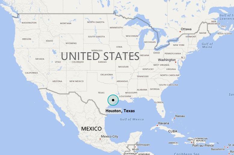
Houston is located in the south-east of the Texas. Houston is the 4th largest city in the United States of America, and the largest city in Texas. Houston is located in Harris County, in the southeastern part of Texas, near the Gulf of Mexico, It lies 29.76 latitude and -95.36 longitude. Houston Known as the "Space City", it is home to NASA's Johnson Space Center. Houston is a major hub for the energy industry, particularly oil and natural gas, and is recognized for its cultural diversity.
Location Map of Houston, Texas

Where is Houston Located, TX?
Houston is located in Southeast Texas near Galveston Bay and the Gulf of Mexico, it is the seat of Harris County and the principal city of the Greater Houston metropolitan area. It comprising a total area of 637.4 square miles (1,651 km2), with an estimated population of 2,316,797 in 2020.
Houston City Facts
| Fact sheet | Houston |
|---|---|
| Continent | North Americatd> |
| State | Texas |
| Location | South-East of Texxas |
| Latitude | 29º45’46”N |
| Longitude | 95º22’59”W |
| Total area | 1,625km2 ( 627.6 sq mi ) |
| Population (2020) | 2,316,797 |
| Zip Codes Code | 770xx, 772xx (P.O. Boxes) |
| Timezone | UTC−6 (CST), In Summer (DST) UTC−5 (CDT) |
| Area Code | 713, 281, 832, 346 |
| Nearby Cities | Macgregor, West University Place, Bellaire, Jacinto City. |
| Major Tourists' Attraction | Gerald D. Hines Water, Water Wall Park, the Galleria, Cockrell Butterfly Center, Rice University. |
| Nearest airport | William P. Hobby Airport (14miles), George Bush Intercontinental Airport (21miles). |
| Interstates | I-10, I-45, I-69, I-610 |
| State Routes | 59, 90, 290 |
| Rapid transit | Houston Metro |
| Website | http://www.houstontx.gov/ |
- Where is Akron
- Where is Anaheim
- Where is Anchorage
- Where is Arlington
- Where is Aurora
- Where is Baltimore
- Where is Baton Rouge
- Where is Birmingham
- Where is Boise City
- Where is Boston
- Where is Buffalo
- Where is Chandler
- Where is Charlotte
- Where is Chesapeake
- Where is Chula Vista
- Where is Cincinnati
- Where is Cleveland
- Where is Colorado Springs
- Where is Columbus
- Where is Corpus Christi
- Where is Des Moines
- Where is Detroit
- Where is Durham
- Where is El Paso
- Where is Fayetteville
- Where is Fort Wayne
- Where is Freemont
- Where is Fresno
- Where is Garland
- Where is Gilbert
- Where is Glendale
- Where is Greensboro
- Where is Henderson
- Where is Hialeah
- Where is Honolulu
- Where is Houston
- Where is Indianapolis
- Where is Irvine
- Where is Irving
- Where is Jacksonville
- Where is Jersey City
- Where is Kansas City
- Where is Laredo
- Where is Lincoln
- Where is Long Beach
- Where is Louisville
- Where is Lubbock
- Where is Madison
- Where is Memphis
- Where is Mesa
- Where is Milwaukee
- Where is Minneapolis
- Where is Modesto
- Where is Montgomery
- Where is Nashville
- Where is Newark
- Where is Norfolk
- Where is North Las Vegas
- Where is Oakland
- Where is Oklahoma City
- Where is Omaha
- Where is Orlando
- Where is Paradise
- Where is Philadelphia
- Where is Phoenix
- Where is Portland
- Where is Raleigh
- Where is Reno
- Where is Richmond
- Where is Riverside
- Where is Rochester
- Where is Sacramento
- Where is Saint Paul
- Where is Saint Petersburg
- Where is San Bernardino
- Where is San Jose
- Where is Santa Ana
- Where is Scottsdale
- Where is Shreveport
- Where is Spokane
- Where is St Louis
- Where is Stockton
- Where is Tampa
- Where is Toledo
- Where is Tucson
- Where is Tulsa
- Where is Virginia Beach
- Where is Wichita
Written and fact-checked by Whereig.com Web Team | Last Updated: January 11, 2025, 11:50 PM ET
