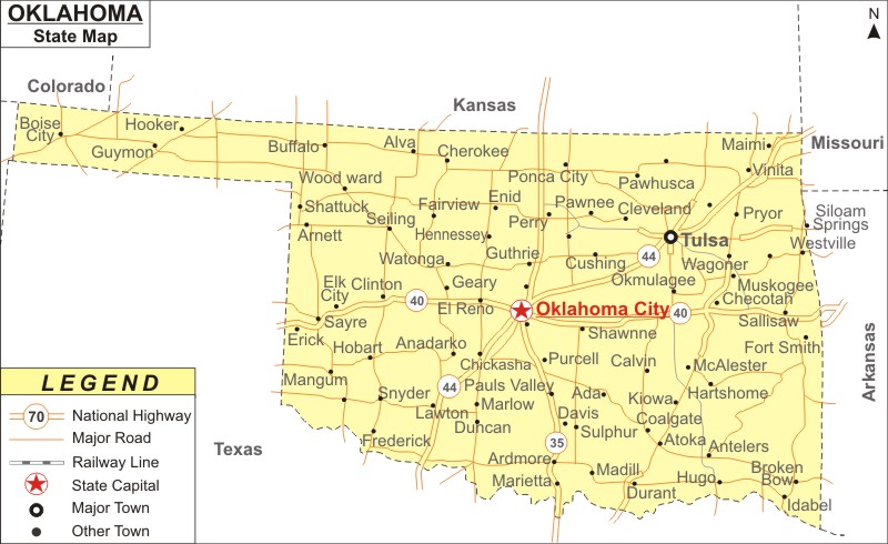
Oklahoma Map: Oklahoma is a state in the South Central region of the United States. Oklahoma is the the 28th-most populous and 20th largest U.S. state in area. It covers an area of 69,898 sq mi (181,038 km2), with population of 3,959,353 people as of 2020 Census.
Map of Oklahoma with Cities, Road, River, Highways
 About Map: Oklahoma Map showing the capital, state boundary, roads, rail network,rivers, interstate highways, major cities and towns.
Oklahoma More Maps & Info
About Oklahoma State Map
Oklahoma is a state located in the South Central region of the United States. Texas borders Oklahoma on the south and west, Kansas on the north, Missouri on the northeast, Arkansas on the east, New Mexico on the west, and Colorado on the northwest. It is the 28th most populous and the 20th largest state in terms of area in all of the 50 United States, partially located in the westernmost portion of the Upland South. The capital city of the state is Oklahoma City, and it is the largest city in the state. Oklahoma map includes state borders, cities, roads, rivers, and lakes.
Oklahoma Map
Oklahoma map provided on this page depicts all of the areas in the state. Oklahoma map shows not only the state borders, but also major highways, roads, railway lines, the state capital Oklahoma City, and other towns. The Oklahoma map can be used to determine the orientation of locations. This website's Oklahoma map is completely free. It is available for free download. This website offers a free map of Oklahoma. You can download it for free.
Oklahoma Map Illustrates Major Cities
The following cities can be located in Oklahoma map: Oklahoma City, Tulsa, Norman, Bartlesville, Broken Arrow, Edmond, Enid, Lawton, Moore, Muskogee, Ponca City, Ardmore, Atoka, Blackwell, Shawnee, Stillwater, Ada, Altus, Alva, Claremore, Duncan, Guymon, Henryetta, Hobart, Holdenville, Anadarko, Antlers, Boise City, Chickash Buffalo, Grove, Coalgate, Sulphur, Waurika, Sayre, Watonga, Pawhuska, Perry, Frederick, Guthrie, Poteau, Pryor, Sapulpa, Seiling, Shattuck, Tahlequah, Woodward, Vinita, Madill and Seminole. Oklahoma map indicates the exam location of all these cities and towns of the state.
Oklahoma Map Indicates National Highways & Routes of the State
Oklahoma map indicates the National Highways and Routes of Oklahoma. We have listed down the Oklahoma Interstates and Oklahoma Routes below.
Facts About Oklahoma
| State Name | Oklahoma |
| Country | United States |
| Continent | North America |
| Capital City | Oklahoma City |
| Largest city | Oklahoma City |
| Abbreviation | OK, Okla. US-OK |
| Joined the Union | November 16, 1907(46th) |
| Nickname | Sooner State |
| Area | 69,898 sq mi (181,038 km2) - Rank 20th |
| Timezone | UTC-7/-6 all of the state (legally) Central: UTC -6/-5, Kenton (informally) Mountain: UTC -7/-6 |
| Population | 3,959,353 (2020 Census) - Rank 28th |
| Highest Point | Black Mesa |
| Lowest Point | Little River at Arkansas border |
| Official Website | www.ok.gov |
