The state of Mississippi is located in the Southern United States, the 32nd largest state and the 35th most populous states of the USA.
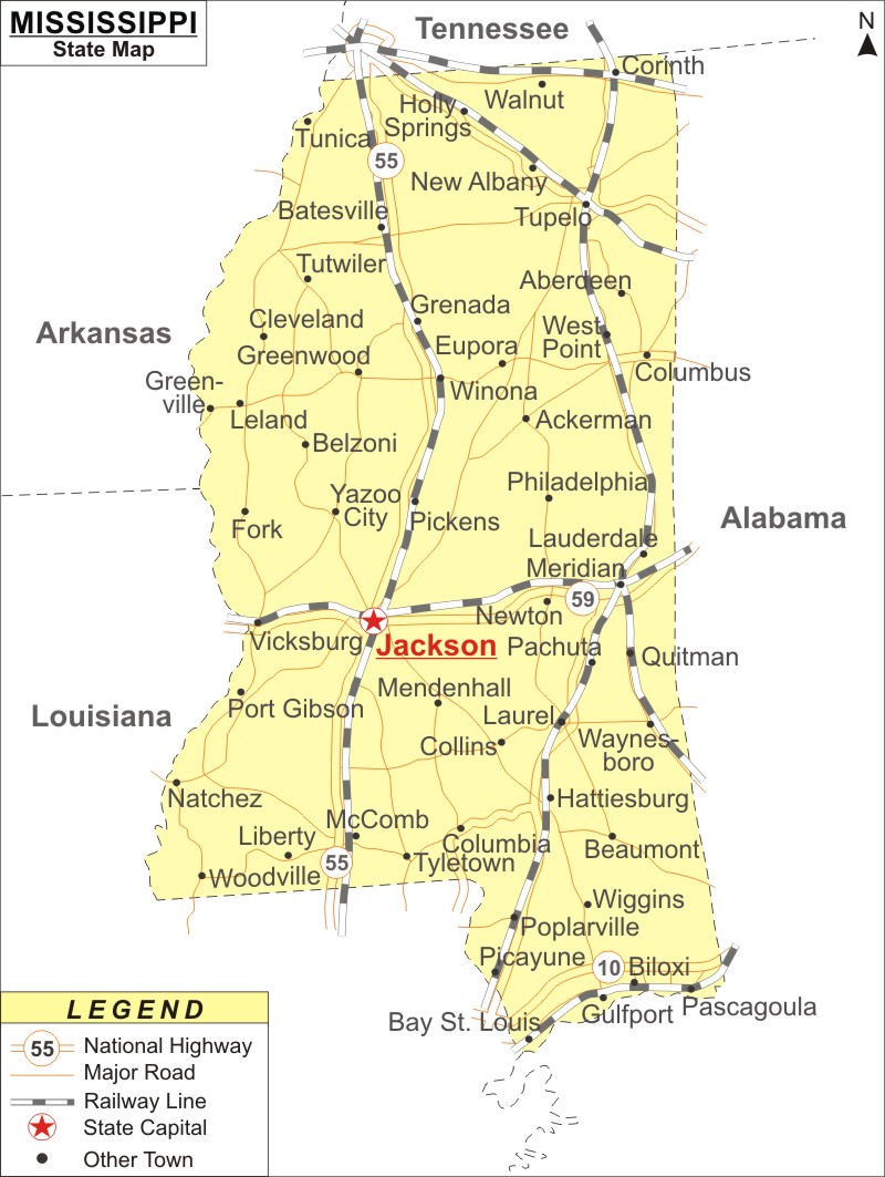
Map of Mississippi with Cities, Road, River, Highways

About Map: Mississippi Map showing the state capital, state boundary, roads, rail network,rivers, interstate highways, major cities and towns.
Other Mississippi Maps & Info
About Mississippi
Mississippi Map: One of the Southeastern states in the United States of America is Mississippi. The same can be seen in the Mississippi Map. The Mississippi River essentially establishes Mississippi's western border. Mississippi has the lowest per capita income in the US and is the 35th most populous and 32nd largest state among the 50 U.S. states. The largest city in the state and its capital are both Jackson. The anticipated population of Mississippi in 2023 is 2.93 million.
Mississippi is the 32nd largest and 35th-most populous of U.S. states. Jackson is the state's capital and largest city.Mississippi Map
The map of Mississippi, which is provided on this page, indicates all the areas that are located in the state. The Mississippi Map shows not only the borders but also National Highways, Major Roads, Railway Lines, State Capital along with the other towns. With the help of Mississippi Map, one can locate the places as per the direction. The Mississippi Map on this website is available without charge. It is available for free download.
Mississippi Geography
Mississippi shares borders with Tennessee to the north, Alabama to the east, Louisiana to the south, and a small portion of the Gulf of Mexico coastline with the west, which lies across the Mississippi River from Louisiana and Arkansas. Mississippi is entirely made up of lowlands, with Woodall Mountain, in the northeastern section of the state, rising to a height of 807 feet above sea level, being the state's highest point. The Gulf Coast's sea level is the lowest point. The state lies on average 300 feet (91 meters) above sea level.
Major rivers in Mississippi, in addition to the one bearing its name, include the Big Black River, the Pearl River, the Yazoo River, the Pascagoula River, and the Tombigbee River. The largest lake is Sardis Lake, and other significant lakes are Ross Barnett Reservoir, Arkabutla, Sardis, and Grenada. Long, hot, and humid summers and brief, mild winters are characteristics of Mississippi's humid subtropical climate.
Facts About Mississippi
| State Name | Mississippi |
| Country | United States |
| Continent | North America |
| Capital City | Jackson |
| Largest city | Jackson |
| Abbreviation | MS, Miss. US-MS |
| Joined the Union | December 10, 1817 (20th) |
| Nickname | Magnolia State |
| Area | 48,430 sq mi (125,443 km2) |
| Timezone | Central: UTC −6/−5 |
| Population (2020 Census) | 2,963,914 (35th) |
| Highest Point | Woodall Mountain |
| Lowest Point | Gulf of Mexico |
| Official Website | https://www.mississippi.gov/ |
Mississippi Interstates
North-South interstates include: Interstate 15, Interstate 17 and Interstate 19. East-West interstates include: Interstate 8, Interstate 10 and Interstate 40.
Mississippi Routes
US Highways and State Routes include: Route 60, Route 70, Route 89, Route 89A, Route 93, Route 95, Route 160, Route 180 and Route 191.
- Where is Akron
- Where is Anaheim
- Where is Anchorage
- Where is Arlington
- Where is Aurora
- Where is Baltimore
- Where is Baton Rouge
- Where is Birmingham
- Where is Boise City
- Where is Boston
- Where is Buffalo
- Where is Chandler
- Where is Charlotte
- Where is Chesapeake
- Where is Chula Vista
- Where is Cincinnati
- Where is Cleveland
- Where is Colorado Springs
- Where is Columbus
- Where is Corpus Christi
- Where is Des Moines
- Where is Detroit
- Where is Durham
- Where is El Paso
- Where is Fayetteville
- Where is Fort Wayne
- Where is Freemont
- Where is Fresno
- Where is Garland
- Where is Gilbert
- Where is Glendale
- Where is Greensboro
- Where is Henderson
- Where is Hialeah
- Where is Honolulu
- Where is Houston
- Where is Indianapolis
- Where is Irvine
- Where is Irving
- Where is Jacksonville
- Where is Jersey City
- Where is Kansas City
- Where is Laredo
- Where is Lincoln
- Where is Long Beach
- Where is Louisville
- Where is Lubbock
- Where is Madison
- Where is Memphis
- Where is Mesa
- Where is Milwaukee
- Where is Minneapolis
- Where is Modesto
- Where is Montgomery
- Where is Nashville
- Where is Newark
- Where is Norfolk
- Where is North Las Vegas
- Where is Oakland
- Where is Oklahoma City
- Where is Omaha
- Where is Orlando
- Where is Paradise
- Where is Philadelphia
- Where is Phoenix
- Where is Portland
- Where is Raleigh
- Where is Reno
- Where is Richmond
- Where is Riverside
- Where is Rochester
- Where is Sacramento
- Where is Saint Paul
- Where is Saint Petersburg
- Where is San Bernardino
- Where is San Jose
- Where is Santa Ana
- Where is Scottsdale
- Where is Shreveport
- Where is Spokane
- Where is St Louis
- Where is Stockton
- Where is Tampa
- Where is Toledo
- Where is Tucson
- Where is Tulsa
- Where is Virginia Beach
- Where is Wichita
