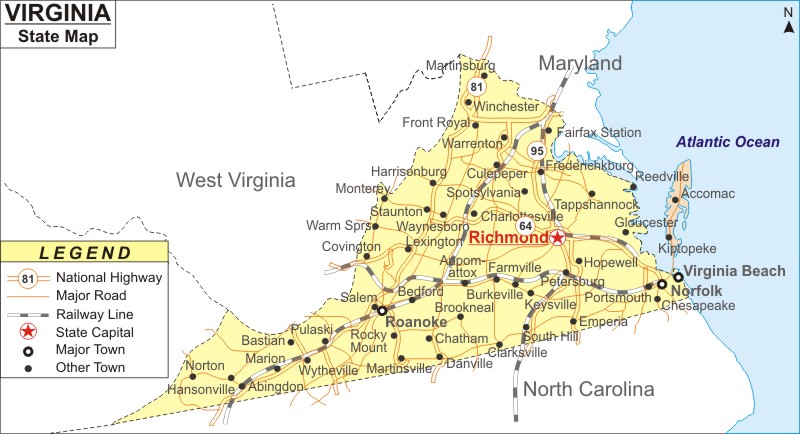
Virginia Map: Virginia is a state in the Mid-Atlantic and Southeastern regions of the United States. Virginia is the the 12th most populous and 35th-largest state by area. It covers an area of 42,774.2 sq mi (110,785 km2) , with population of 8,631,393 people according to 2020 U.S. Census.
Map of Virginia with Cities, Road, River, Highways
 About Map: Virginia Map showing the capital, state boundary, roads, rail network,rivers, interstate highways, major cities and towns.
Virginia More Maps & Info
About Virginia State Map
The State of Virginia is also known as the Commonwealth of Virginia. It is located between the Atlantic Coast and the Appalachian Mountains. Virginia is in the Mid-Atlantic and Southeastern areas of the United States. The Blue Ridge Mountains and the Chesapeake Bay, which serve as habitat for a large portion of the Commonwealth's flora and wildlife, have altered the terrain and climate of the state. The most populated city in the Commonwealth is Virginia Beach, while Fairfax County is the most populous political unit. Richmond serves as the capital of the Commonwealth of Virginia. Maryland and Washington, D.C. bound the Commonwealth to the north and east, to the east by the Atlantic Ocean, to the south by North Carolina, to the southwest by Tennessee, to the west by Kentucky, and to the north and west by West Virginia. All these borders of the Commonwealth of Virginia could be seen clearly in Virginia map.
Virginia Map
The detailed map of Virginia depicts the state's boundaries, the location of the state capital, Richmond, major cities and other populated areas, rivers and lakes, major highways, interstates, railroads, and airports, and other geographical features. This Virginia map can be used for both educational and non-educational purposes. It is available for free download.
Virginia Map Illustrates Major Cities
The major town of Virginia can be easily spotted in Virginia map. The major towns like Virginia Beach, Chesapeake, Norfolk, Richmond, Newport News, Alexandria, and Hampton are indicated with special symbol to identify them in Virginia map. The location of other small towns of the commonwealth of Virginia is indicated in the map.
Virginia Map Indicates National Highways & Routes of the State
The Virginia map displays all of the National Highways and Routes because they are part of the state's transportation system. Information regarding national highways and routes is provided below.
Facts About Virginia
| State Name | Virginia |
| Country | United States |
| Continent | North America |
| Capital City | Richmond |
| Largest city | Virginia Beach |
| Abbreviation | VA, US-VA |
| Joined the Union | June 25, 1788 (10th) |
| Nickname | Old Dominion; Mother of Presidents, Mother of states |
| Area | 42,774.2 sq mi (110,785.67 km2) |
| Timezone | Eastern: UTC −5/−4 |
| Population (2020) | 8,631,393 - 12th Rank |
| Highest Point | Mount Rogers |
| Lowest Point | Atlantic Ocean sea level |
| Official Website | www.virginia.gov |
