
Written and Fact-checked by Whereig Editors | Last Updated On: June 18, 2026
Rio de Janeiro is a city in the state of Rio de Janeiro, Brazil, located on the country's southeastern Atlantic coast. Situated at approximately 22.9068° S latitude and 43.1729° W longitude, the city covers about 1,221 sq km (471 sq mi) and has an estimated population of around 6.7 million people.
Location Map of Rio de Janeiro, Brazil
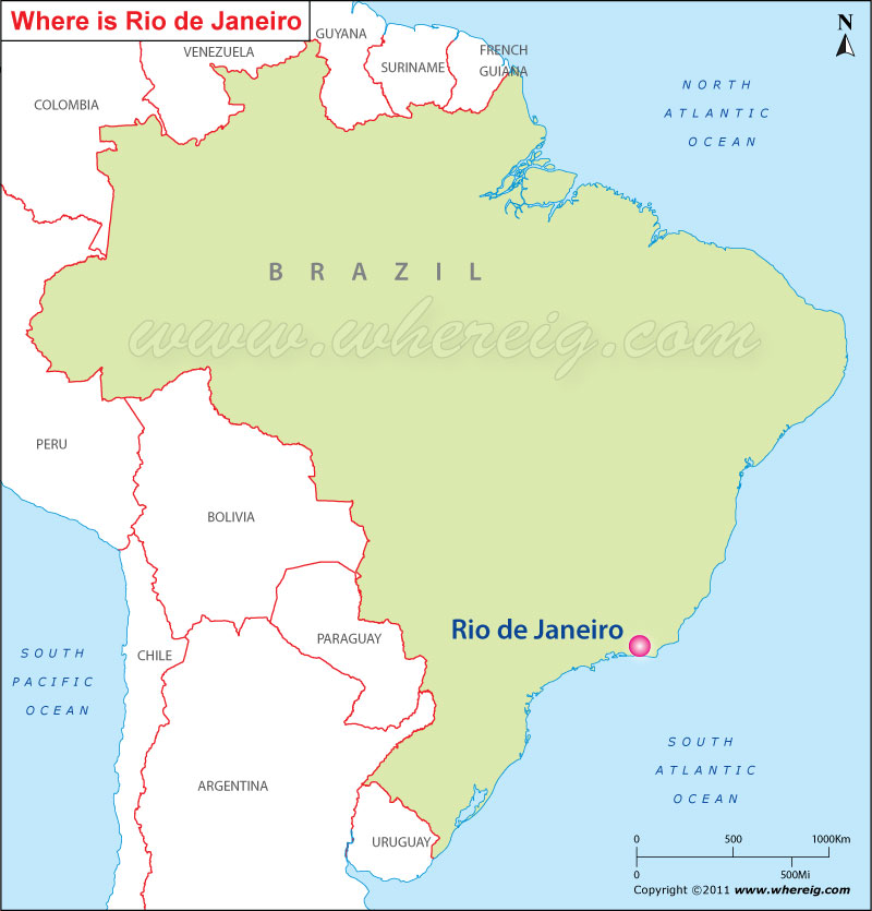
About Map: The map shows the location of Rio de Janeiro in the Brazil.
Where is Rio de Janeiro Located?
It is the capital city of the state Rio de Janeiro. Rio de Janeiro is the second largest city of Brazil. Interestingly, in the past Rio de Janeiro was the capital city of Brazil almost for one and half centuries i.e. from 1763 to 1815 Rio de Janeiro is more popularly known as 'Rio' and the nicknamed is the Cidade Maravilhosa or "Marvelous City". The city Rio is important business center and largest conglomerate of media and communications companies of South America. Besides, it has several universities and institutes; it is also the second largest center of research and development in Brazil.
Moreover, Rio de Janeiro is the most visited city in the southern hemisphere because of its natural settings, samba, Bossa Nova, balneario beaches such as Barra da Tijuca, Copacabana, Ipanema, and Leblon, and also for carnival celebrations.
Furthermore, the city is known for plenty of landmark features including the giant statue of Christ the Redeemer ('Cristo Redentor') atop Corcovado mountain, named one of the New Seven Wonders of the World; the Sambodromo, a permanent grandstand-lined parade avenue which is used during Carnival; Sugarloaf mountain (Pao de Acucar) with its cable car; and Maracana Stadium, one of the world's largest football stadiums. The final match for 2014 FIFA World Cup will take place at Rio's Maracana Stadium and Rio de Janeiro will also host the 2016 Summer Olympics that will definitely marked as the first time a South American city hosts the event.
Rio de Janeiro, Brazil Quick Facts
| Fact | Details |
|---|---|
| City | Rio de Janeiro |
| State | Rio de Janeiro |
| Country | Brazil |
| Former National Capital | Yes (1763-1960) |
| Region | Southeast Brazil |
| Latitude | 22.9068° S |
| Longitude | 43.1729° W |
| Elevation | 16 ft (5 m) |
| Land Area | 470 sq mi |
| Water Area | Includes bays, lagoons and coastal waters |
| Total Area | 470 sq mi |
| Population (Latest Estimate) | Approximately 6.7 million |
| Population Density | Approximately 14,300 per sq mi |
| Postal Codes | 20000-23799 |
| Area Code | +55 21 |
| Time Zone Standard | Brasília Time (UTC-3) |
| Time Zone Daylight | No daylight saving time observed |
| Currency | Brazilian Real (BRL) |
| Administrative Code | Municipality of Rio de Janeiro |
| National Representation | National Congress Constituencies |
Nearby Cities to Rio de Janeiro, Brazil
- Niterói, Brazil - 8 mi East
- Duque de Caxias, Brazil - 13 mi North
- São João de Meriti, Brazil - 16 mi North
- Nova Iguaçu, Brazil - 23 mi Northwest
- Belford Roxo, Brazil - 19 mi North
- Magé, Brazil - 28 mi North
- Itaboraí, Brazil - 32 mi East
- Petrópolis, Brazil - 43 mi North
- Teresópolis, Brazil - 59 mi North
- Angra dos Reis, Brazil - 97 mi Southwest
Rio de Janeiro, Brazil Climate and Weather Overview
| Month | Avg High (°F) | Avg Low (°F) | Avg Rainfall (in) |
|---|---|---|---|
| January | 87 | 75 | 5.4 |
| April | 83 | 71 | 4.0 |
| July | 78 | 66 | 1.8 |
| October | 82 | 70 | 3.5 |
| Annual | 82 | 70 | 45.0 |
| Climate Attribute | Details |
|---|---|
| Climate Classification (Köppen) | Aw - Tropical Savanna |
| Annual Rainfall | Approximately 45 inches |
| Annual Sunshine Days | More than 2,100 sunshine hours |
| Hurricane/Tornado Risk | Very Low |
| Snowfall | No snowfall |
Driving Distances from Rio de Janeiro, Brazil
| City | State | Distance (mi) | Approx. Drive Time |
|---|---|---|---|
| Niterói | Rio de Janeiro | 8 | 20 min |
| Duque de Caxias | Rio de Janeiro | 13 | 25 min |
| São João de Meriti | Rio de Janeiro | 16 | 30 min |
| Belford Roxo | Rio de Janeiro | 19 | 35 min |
| Nova Iguaçu | Rio de Janeiro | 23 | 40 min |
| Magé | Rio de Janeiro | 28 | 45 min |
| Itaboraí | Rio de Janeiro | 32 | 50 min |
| Petrópolis | Rio de Janeiro | 43 | 1 hr |
| Teresópolis | Rio de Janeiro | 59 | 1 hr 20 min |
| Angra dos Reis | Rio de Janeiro | 97 | 2 hr |
Transportation and Connectivity in Rio de Janeiro, Brazil
| Airport Name | Rio de Janeiro-Galeão International Airport |
| IATA Code | GIG |
| Port | Port of Rio de Janeiro |
| Major Highways | BR-101, BR-040, BR-116, Linha Vermelha |
| Train Service | SuperVia Commuter Rail |
| Local Transit Service | Rio Metro, BRT, Buses and Ferries |
- BR-101 - Coastal highway connecting Rio with major cities along Brazil's Atlantic coast.
- BR-040 - Links Rio de Janeiro with Petrópolis and Brasília.
- BR-116 - One of Brazil's most important long-distance highways.
- Linha Vermelha - Major expressway connecting downtown with the airport.
- Rio Metro - Rapid transit system serving much of the metropolitan area.
Key Landmarks and Places to Visit in Rio de Janeiro, Brazil
| Landmark Name | Type |
|---|---|
| Christ the Redeemer | Monument |
| Sugarloaf Mountain | Natural Landmark |
| Copacabana Beach | Beach |
| Ipanema Beach | Beach |
| Maracanã Stadium | Sports Venue |
| Tijuca National Park | National Park |
| Sambadrome | Cultural Venue |
| Selarón Steps | Art Landmark |
| Municipal Theatre | Historic Building |
| Botanical Garden | Botanical Garden |
Places to Visit in Rio de Janeiro, Brazil
| Landmark Name | Type |
|---|---|
| Christ the Redeemer | Monument |
| Sugarloaf Mountain | Natural Landmark |
| Copacabana Beach | Beach |
| Ipanema Beach | Beach |
| Maracanã Stadium | Sports Venue |
| Tijuca National Park | National Park |
| Sambadrome | Cultural Venue |
| Selarón Steps | Art Landmark |
| Municipal Theatre | Historic Building |
| Botanical Garden | Botanical Garden |
Colleges and Universities in Rio de Janeiro, Brazil
| Institution Name | Type | Level | Notable For |
|---|---|---|---|
| Federal University of Rio de Janeiro | Public | University | Research and science |
| State University of Rio de Janeiro | Public | University | Education and public policy |
| Pontifical Catholic University of Rio de Janeiro | Private | University | Engineering and technology |
| Federal Rural University of Rio de Janeiro | Public | University | Agricultural sciences |
| Veiga de Almeida University | Private | University | Business and communication |
Waterbodies in Rio de Janeiro, Brazil
Guanabara Bay, Atlantic Ocean, Rodrigo de Freitas Lagoon, Jacarepaguá Lagoon, Marapendi Lagoon, Tijuca Lagoon, Carioca River, Guandu River, Sepetiba Bay, Camorim Lagoon
Golf Courses in Rio de Janeiro, Brazil
Olympic Golf Course, Itanhangá Golf Club, Gávea Golf and Country Club, Teresópolis Golf Club, Petrópolis Golf Club, Frade Golf Club, Fazenda Boa Vista Golf Course, Búzios Golf Club, Rio de Janeiro Country Club, Aretê Búzios Golf Club
Rio de Janeiro, Brazil - Key Historical Facts
- Rio de Janeiro was founded by the Portuguese in 1565 and developed into a major colonial port.
- The city served as the capital of Brazil from 1763 until 1960.
- Rio became the seat of the Portuguese royal court during the Napoleonic Wars.
- The city played a major role in Brazil's political, cultural and economic development.
- Its famous beaches, mountains and Carnival celebrations have made Rio internationally recognized.
- Today, Rio de Janeiro remains one of Brazil's most visited cities and a leading center for tourism, culture and sports.
References
- Rio de Janeiro City Hall
- Brazilian Institute of Geography and Statistics (IBGE)
- Visit Rio
- Encyclopaedia Britannica - Rio de Janeiro