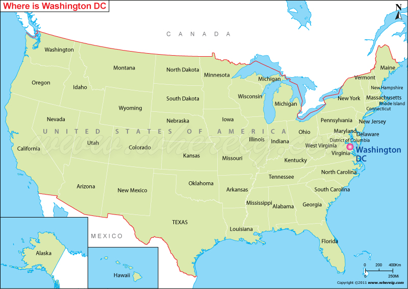
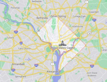
Washington DC is located in the north-eastern part of the United States. It's situated between Virginia and Maryland on the northern edge of the Potomac River. See below the Washington DC location map showing its location on the US Map.
Location Map of Washington DC, the capital of the United States
 About Map: The Map showing Where is Washington D.c. located the United States.
Map Showing the Border of Washington, D.C

Where is Washington DC?
Washington, D.C. is the capital city of the United States located on the north bank of the Potomac River and shares border with the states of Virginia in the southwest and with Maryland in the other sides. The DC refers District of Columbia. Under the special condition, the US Constitution has created the special district to serve as the permanent national capital. Washington, D.C. founded after the American Revolution, Washington was named for George Washington, the first Presidents of the United States.
Interestingly, under the special act of Congress in 1871, the City of Washington, along with Georgetown and surrounding areas within the federal district, has been placed under a single, unified government. This is why the city technically named as the District of Columbia or simply known as Washington, D.C. The city shares its name with the U.S. state of Washington, which is located on the country's Pacific coast.
Moreover, Washington D.C. hosts 174 foreign embassies along with the headquarters of the World Bank, the International Monetary Fund (IMF), the Inter-American Development Bank, the Organization of American States (OAS), and the Pan American Health Organization (PAHO).
The capital city has three rivers flowing through it - the River Potomac and its tributaries Rock Creek and River Anacostia. It is not a part of any U.S state and the capital district is under the jurisdiction of the United States Congress.
In and Around Washington DC
Washington DC is served by two international airports - Washington Dulles International Airport (IAD), Baltimore-Washington International Thurgood Marshall Airport (BWI), and one national airport Ronald Reagan Washington National Airport (DCA). The city has a well connected system of metro rails, buses, and taxis. Road congestion does tend to be a problem, though.
Washington D.C. Facts
| Country | United States |
| Federal District | District of Columbia |
| Location | North-east of the United States |
| Washington DC Coordinates | 38.9072° N, 77.0369° W |
| Abbreviations | DC |
| Named after | George Washington |
| Founded | July 16, 1790 |
| Area of Washington DC | 68.3 sq mi (177.0 km2) |
| Population of Washington D.C | 705,749 (as of July 2019, U.S. Census Bureau Data) |
| Population Dencity | 11,506/sq mi (4,442/km2) |
| Demographics | White: 38.5%, Non-Hispanic whites: 34.8%, Black or African American: 50.7%, Hispanic or Latino: 9.1% & Asian- 3.5% |
| Time Zone of Wshington DC | UTC−5 (EST), in Summer UTC−4 (EDT) |
| ZIP Codes of Washington DC | 20001-20098, 20201-20599 |
| Washington DC Area code | 202 |
| Washington DC Climate | Humid Subtropical Climate |
| Highest Elevation | 409 ft (125 m) |
| Major Airport in D.C. | Washington Dulles, Reagan National & Baltimore-Washington |
| Official Website | http://dc.gov/ |
Also Check Location Map of White House, United States
Which is the best Season to visit Washington DC?
Spring and fall are the best seasons to visit the city. Spring in Washington is beautiful with blooming cherry blossoms all over the city; the weather, though, does get unpredictable. September and October are great months to visit Washington as the weather is pretty pleasant during this time. If you want to catch the government in action, do plan a visit when the Congress is in session.
Top Places to Visit in Washington D.C.:
Washington DC is a city known for its monuments. Visit the United States Capitol and brush shoulders with history. The top attractions to visit in Washington DC are:
| United States Capitol | cruise across the Potomac River | United States Botanic Garden |
| Lincoln Memorial | Smithsonian Institution Museums | National Museum of African American |
| The White House, National Mall | National Gallery of Art | United States National Arboretum |
| Smithsonian National Museum of Natural History | Vietnam Veterans Memorial | Hirshhorn Museum, Rock Creek Park |
| Washington Monument | Library of Congress | Supreme Court of the United States |
| Smithsonian National Zoo | Martin Luther King, Jr. Memorial | West Potomac Park |
| Bureau of Engraving & Printing | Smithsonian Castle | Lincoln Memorial Reflecting Pool |
| International Spy Museum | The Pentagon & Newseum | National Geographic Museum |
Distances From Washington DC to Other U.S. States:
| State | Distance in Miles | Distance in KM |
|---|---|---|
| Distance from Washington, D.C. to Alabama | 716 miles | 1,153 km |
| Distance from Washington, D.C. to Arizona | 1,910 miles | 3,074 km |
| Distance from Washington, D.C. to Arkansas | 854 miles | 1,374 km |
| Distance from Washington, D.C. to California | 2,297 miles | 3,696 km |
| Distance from Washington, D.C. to Colorado | 1,532 miles | 2,466 km |
| Distance from Washington, D.C. to Connecticut | 280 miles | 450 km |
| Distance from Washington, D.C. to Delaware | 81 miles | 131 km |
| Distance from Washington, D.C. to Florida | 818 miles | 1,317 km |
| Distance from Washington, D.C. to Georgia | 570 miles | 918 km |
| Distance from Washington, D.C. to Idaho | 1,966 miles | 3,164 km |
| Distance from Washington, D.C. to Illinois | 667 miles | 1,073 km |
| Distance from Washington, D.C. to Indiana | 493 miles | 794 km |
| Distance from Washington, D.C. to Iowa | 868 miles | 1,397 km |
| Distance from Washington, D.C. to Kansas | 1,150 miles | 1,850 km |
| Distance from Washington, D.C. to Louisiana | 1,005 miles | 1,617 km |
| Distance from Washington, D.C. to Maine | 586 miles | 943 km |
| Distance from Washington, D.C. to Maryland | 24 miles | 38 km |
| Distance from Washington, D.C. to Michigan | 578 miles | 931 km |
| Distance from Washington, D.C. to Minnesota | 1,041 miles | 1,676 km |
| Distance from Washington, D.C. to Mississippi | 828 miles | 1,332 km |
| Distance from Washington, D.C. to Missouri | 802 miles | 1,291 km |
| Distance from Washington, D.C. to Montana | 1,759 miles | 2,831 km |
| Distance from Washington, D.C. to Nebraska | 1,216 miles | 1,957 km |
| Distance from Washington, D.C. to Nevada | 2,102 miles | 3,383 km |
| Distance from Washington, D.C. to New Hampshire | 411 miles | 661 km |
| Distance from Washington, D.C. to New Jersey | 162 miles | 260 km |
| Distance from Washington, D.C. to New Mexico | 1,619 miles | 2,605 km |
| Distance from Washington, D.C. to New York | 204 miles | 328 km |
| Distance from Washington, D.C. to North Carolina | 243 miles | 391 km |
| Distance from Washington, D.C. to North Dakota | 1,338 miles | 2,154 km |
| Distance from Washington, D.C. to Ohio | 329 miles | 530 km |
| Distance from Washington, D.C. to Oklahoma | 1,137 miles | 1,830 km |
| Distance from Washington, D.C. to Oregon | 2,256 miles | 3,630 km |
| Distance from Washington, D.C. to Rhode Island | 346 miles | 557 km |
| Distance from Washington, D.C. to South Carolina | 419 miles | 674 km |
| Distance from Washington, D.C. to South Dakota | 1,230 miles | 1,980 km |
| Distance from Washington, D.C. to Tennessee | 575 miles | 925 km |
| Distance from Washington, D.C. to Texas | 1,369 miles | 2,203 km |
| Distance from Washington, D.C. to Utah | 1,815 miles | 2,921 km |
| Distance from Washington, D.C. to Vermont | 453 miles | 729 km |
| Distance from Washington, D.C. to Virginia | 135 miles | 217 km |
| Distance from Washington, D.C. to West Virginia | 185 miles | 298 km |
| Distance from Washington, D.C. to Wisconsin | 695 miles | 1,119 km |
FAQs about Washington DC
Ans. Washington D.C. is not in any state. It is a federal district that act as the capital of the United States. Washington DC also known as D.C is not one of the 50 states of the United States. The District of Columbia, which was formed particularly to house the federal government and is located between the states of Maryland and Virginia on the east coast of the United States.
Ans. Washington DC is located on the Potomac River bordering Maryland and Virginia, in the mid-Atlantic region of the U.S. East Coast.
Ans. Washington D.C. is bordered by 2 US states, Virginia and Maryland. Virginia to the southern shore of the Potomac River and Maryland to the north, east, and west.
- Where is Akron
- Where is Anaheim
- Where is Anchorage
- Where is Arlington
- Where is Aurora
- Where is Baltimore
- Where is Baton Rouge
- Where is Birmingham
- Where is Boise City
- Where is Boston
- Where is Buffalo
- Where is Chandler
- Where is Charlotte
- Where is Chesapeake
- Where is Chula Vista
- Where is Cincinnati
- Where is Cleveland
- Where is Colorado Springs
- Where is Columbus
- Where is Corpus Christi
- Where is Des Moines
- Where is Detroit
- Where is Durham
- Where is El Paso
- Where is Fayetteville
- Where is Fort Wayne
- Where is Freemont
- Where is Fresno
- Where is Garland
- Where is Gilbert
- Where is Glendale
- Where is Greensboro
- Where is Henderson
- Where is Hialeah
- Where is Honolulu
- Where is Houston
- Where is Indianapolis
- Where is Irvine
- Where is Irving
- Where is Jacksonville
- Where is Jersey City
- Where is Kansas City
- Where is Laredo
- Where is Lincoln
- Where is Long Beach
- Where is Louisville
- Where is Lubbock
- Where is Madison
- Where is Memphis
- Where is Mesa
- Where is Milwaukee
- Where is Minneapolis
- Where is Modesto
- Where is Montgomery
- Where is Nashville
- Where is Newark
- Where is Norfolk
- Where is North Las Vegas
- Where is Oakland
- Where is Oklahoma City
- Where is Omaha
- Where is Orlando
- Where is Paradise
- Where is Philadelphia
- Where is Phoenix
- Where is Portland
- Where is Raleigh
- Where is Reno
- Where is Richmond
- Where is Riverside
- Where is Rochester
- Where is Sacramento
- Where is Saint Paul
- Where is Saint Petersburg
- Where is San Bernardino
- Where is San Jose
- Where is Santa Ana
- Where is Scottsdale
- Where is Shreveport
- Where is Spokane
- Where is St Louis
- Where is Stockton
- Where is Tampa
- Where is Toledo
- Where is Tucson
- Where is Tulsa
- Where is Virginia Beach
- Where is Wichita
