
As shown on the given New York location map that New York City is located on a large natural harbor on the Atlantic coast in the north-eastern part of the United States. New York City is also the most populous city and major city in the United States.
Location Map of New York City (NYC)
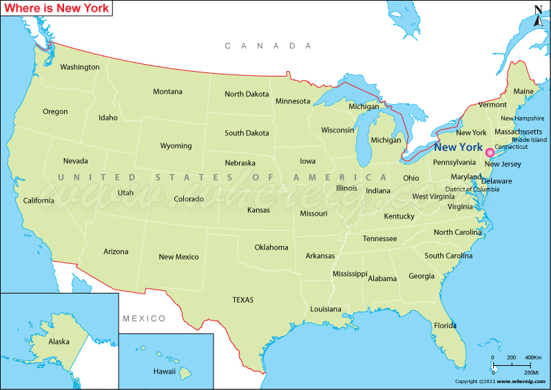
About Map: The Map showing where is New York City (NYC) location in the U.S. State of New York.
Where is New York City (NYC)?
New York City is the most populous city of United States. New York City has a significant position in the world; it is the leading center of global commerce, finance, research, education, culture, media, art, fashion, and entertainment. Furthermore, it is the headquarters of United Nations and also an important center for international affairs.
The city New York is more often called as New York City in order to distinguish between the New York state and New York City. New York City is the most densely populated city of the United States. Surprisingly, about 800 languages are being spoken in the New York City. New York City is a financial district, anchored by Wall Street in Lower Manhattan. City functions as the financial capital of the world and homes world's largest stock exchange New York Stock Exchange. It is the significant center of the world's entertainment industry. Chinatown of Manhattan incorporates the highest percentage of Chinese people in the entire Western Hemisphere.
Moreover, the world famous Times Square, globally recognized as "The Crossroads of the World".
New York City, New York Quick Facts
| City | New York City |
| County | Bronx County, Kings County, New York County, Queens County, Richmond County |
| State | New York |
| State Capital | Albany |
| US Region | Northeast |
| Latitude | 40.7128° N |
| Longitude | 74.0060° W |
| Elevation | 33 ft (10 m) |
| Land Area (sq mi) | 300.46 |
| Water Area (sq mi) | 168.53 |
| Total Area (sq mi) | 468.99 |
| Population (2020 Census) | 8,804,190 |
| Population Density (per sq mi) | 29,300 |
| ZIP Codes | 10001-11697 |
| Area Code | 212, 332, 347, 646, 718, 917, 929 |
| Time Zone Standard | Eastern Standard Time (UTC-5) |
| Time Zone Daylight | Eastern Daylight Time (UTC-4) |
| Currency | United States Dollar (USD) |
| FIPS Code | 36-51000 |
| Congressional District | Multiple Congressional Districts |
Nearby Cities to New York City, New York
- Jersey City, New Jersey - 4 mi West
- Hoboken, New Jersey - 3 mi Northwest
- Newark, New Jersey - 10 mi Southwest
- Yonkers, New York - 17 mi North
- Mount Vernon, New York - 16 mi Northeast
- New Rochelle, New York - 19 mi Northeast
- White Plains, New York - 27 mi Northeast
- Elizabeth, New Jersey - 15 mi Southwest
- Paterson, New Jersey - 20 mi Northwest
- Stamford, Connecticut - 36 mi Northeast
New York City, New York Climate and Weather Overview
| Month | Avg High (°F) | Avg Low (°F) | Avg Rainfall (in) |
|---|---|---|---|
| January | 39 | 27 | 3.6 |
| April | 61 | 45 | 4.5 |
| July | 85 | 71 | 4.6 |
| October | 65 | 52 | 4.4 |
| Annual | 63 | 49 | 49.9 |
| Climate Classification (Köppen) | Humid Subtropical (Cfa) |
| Annual Rainfall | 49.9 in |
| Annual Sunshine Days | 224 |
| Hurricane/Tornado Risk | Moderate Hurricane Risk, Low Tornado Risk |
| Snowfall | 25.8 in |
Driving Distances from New York City, New York
| City | State | Distance (mi) | Approx. Drive Time |
|---|---|---|---|
| Newark | New Jersey | 10 | 20 min |
| Yonkers | New York | 17 | 30 min |
| White Plains | New York | 27 | 40 min |
| Stamford | Connecticut | 36 | 50 min |
| Trenton | New Jersey | 61 | 1 hr 10 min |
| New Haven | Connecticut | 82 | 1 hr 30 min |
| Philadelphia | Pennsylvania | 95 | 1 hr 45 min |
| Hartford | Connecticut | 117 | 2 hr 10 min |
| Albany | New York | 145 | 2 hr 30 min |
| Boston | Massachusetts | 215 | 4 hr |
Transportation and Connectivity in New York City, New York
| Airport Name | John F. Kennedy International Airport, LaGuardia Airport, Newark Liberty International Airport |
| IATA Code | JFK, LGA, EWR |
| Port | Port of New York and New Jersey |
| Major Highways | I-78, I-87, I-95, I-278, I-495 |
| Train/Amtrak Service | Available via Penn Station and Moynihan Train Hall |
| Local Bus/Transit Service | MTA Subway, MTA Bus, Staten Island Railway, PATH |
- Interstate 95 - Main East Coast highway connecting major cities from Florida to Maine.
- Interstate 87 - Connects New York City with Albany, the Adirondacks, and Canada.
- Interstate 278 - Links Staten Island, Brooklyn, Queens, and the Bronx.
- Interstate 495 - Runs east-west through Midtown Manhattan and Long Island.
- Interstate 78 - Provides access to New Jersey and regional transportation networks.
Key Landmarks and Places to Visit in New York City, New York
| Landmark Name | Type |
|---|---|
| Statue of Liberty | Monument |
| Central Park | Park |
| Times Square | Entertainment District |
| Empire State Building | Historic Landmark |
| Brooklyn Bridge | Historic Site |
| Metropolitan Museum of Art | Museum |
| American Museum of Natural History | Museum |
| One World Observatory | Observation Deck |
| Rockefeller Center | Entertainment Complex |
| The High Line | Urban Park |
Economy and Major Employers in New York City, New York
| Sector | Major Employer or Industry | Notes |
|---|---|---|
| Government | City of New York | Largest municipal employer in the city. |
| Finance | Wall Street Financial Services | Global center for banking and investment. |
| Healthcare | NYC Health + Hospitals | Operates hospitals and healthcare facilities citywide. |
| Education | New York City Public Schools | Largest public school system in the United States. |
| Technology | Technology and Software Companies | Fast-growing employment sector. |
| Tourism | Hospitality and Entertainment Industry | Supports millions of annual visitors. |
| Media | Publishing and Broadcasting Companies | National center for news and media production. |
| Retail | Retail and Consumer Services | Major contributor to employment and commerce. |
Colleges and Universities in New York City, New York
| Institution Name | Type (Public/Private) | Level | Notable For |
|---|---|---|---|
| Columbia University | Private | University | Ivy League research university |
| New York University (NYU) | Private | University | Global research and professional programs |
| Fordham University | Private | University | Jesuit higher education |
| St. John's University | Private | University | Catholic university in Queens |
| Yeshiva University | Private | University | Jewish and secular academic programs |
| Pace University | Private | University | Business and professional studies |
| The New School | Private | University | Design and social sciences |
| Pratt Institute | Private | University | Architecture and design education |
| City College of New York | Public | University | Engineering and public education |
| Baruch College | Public | College | Business and finance programs |
| Hunter College | Public | College | Health sciences and liberal arts |
| Brooklyn College | Public | College | Comprehensive undergraduate programs |
| Queens College | Public | College | Arts and sciences education |
| LaGuardia Community College | Public | Community College | Career and transfer pathways |
Waterbodies in New York City, New York
Hudson River, East River, Harlem River, Upper New York Bay, Lower New York Bay, Jamaica Bay, Long Island Sound, Arthur Kill, Kill Van Kull, Newtown Creek
Golf Courses in New York City, New York
Trump Golf Links at Ferry Point, Marine Park Golf Course, Dyker Beach Golf Course, Forest Park Golf Course, Kissena Golf Course, Van Cortlandt Golf Course, Pelham Bay and Split Rock Golf Courses, Silver Lake Golf Course, La Tourette Golf Course, Clearview Park Golf Course
New York City, New York - Key Historical Facts
- New York City was founded by Dutch settlers in 1624 and was originally known as New Amsterdam.
- The English gained control of the settlement in 1664 and renamed it New York.
- New York City served as the first capital of the United States from 1789 to 1790.
- The opening of the Erie Canal in 1825 helped transform the city into a major trade center.
- The five boroughs consolidated into modern New York City in 1898.
- Millions of immigrants entered the United States through nearby Ellis Island between 1892 and 1954.
- Where is Akron
- Where is Anaheim
- Where is Anchorage
- Where is Arlington
- Where is Aurora
- Where is Baltimore
- Where is Baton Rouge
- Where is Birmingham
- Where is Boise City
- Where is Boston
- Where is Buffalo
- Where is Chandler
- Where is Charlotte
- Where is Chesapeake
- Where is Chula Vista
- Where is Cincinnati
- Where is Cleveland
- Where is Colorado Springs
- Where is Columbus
- Where is Corpus Christi
- Where is Des Moines
- Where is Detroit
- Where is Durham
- Where is El Paso
- Where is Fayetteville
- Where is Fort Wayne
- Where is Freemont
- Where is Fresno
- Where is Garland
- Where is Gilbert
- Where is Glendale
- Where is Greensboro
- Where is Henderson
- Where is Hialeah
- Where is Honolulu
- Where is Houston
- Where is Indianapolis
- Where is Irvine
- Where is Irving
- Where is Jacksonville
- Where is Jersey City
- Where is Kansas City
- Where is Laredo
- Where is Lincoln
- Where is Long Beach
- Where is Louisville
- Where is Lubbock
- Where is Madison
- Where is Memphis
- Where is Mesa
- Where is Milwaukee
- Where is Minneapolis
- Where is Modesto
- Where is Montgomery
- Where is Nashville
- Where is Newark
- Where is Norfolk
- Where is North Las Vegas
- Where is Oakland
- Where is Oklahoma City
- Where is Omaha
- Where is Orlando
- Where is Paradise
- Where is Philadelphia
- Where is Phoenix
- Where is Portland
- Where is Raleigh
- Where is Reno
- Where is Richmond
- Where is Riverside
- Where is Rochester
- Where is Sacramento
- Where is Saint Paul
- Where is Saint Petersburg
- Where is San Bernardino
- Where is San Jose
- Where is Santa Ana
- Where is Scottsdale
- Where is Shreveport
- Where is Spokane
- Where is St Louis
- Where is Stockton
- Where is Tampa
- Where is Toledo
- Where is Tucson
- Where is Tulsa
- Where is Virginia Beach
- Where is Wichita