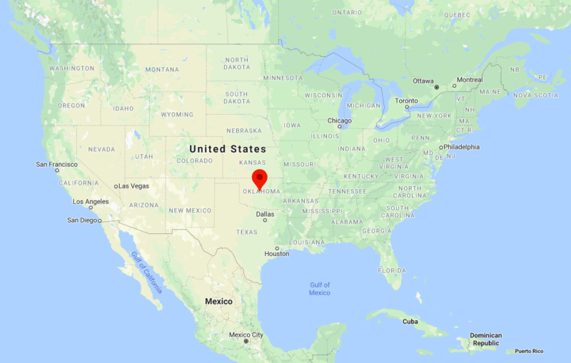
Oklahoma City is located in the central part of the Oklahoma state, United States. It is the capital and largest city of the state Oklahoma.Oklahoma City has one of the largest livestock markets in the world.
Oklahoma More Maps & Info
| Sr. No | Fact sheet | Oklahoma City |
|---|---|---|
| 1 | Country | USA |
| 2 | State | Oklahoma |
| 3 | Location | Central part of the State |
| 4 | Latitude | 35.28′56″N |
| 5 | Longitude | 97.32′6″W |
| 6 | Total area | 1,609km2 ( 621 sq mi ) |
| 7 | Total Population | 591,967 |
| 8 | Zip Codes | 73101 |
| 9 | Area code | 405 |
| 10 | Nearby Cities | Del City, Moore, Norman, Mustang |
| 11 | Major Tourists' Attraction | Oklahoma City National Memorial, Myriad Botanical Gardens, Omniplex, White Water Bay |
| 12 | Nearest airport | Will Rogers World Airport (about 10 miles) |
US Cities Location
- Where is Akron
- Where is Anaheim
- Where is Anchorage
- Where is Arlington
- Where is Aurora
- Where is Baltimore
- Where is Baton Rouge
- Where is Birmingham
- Where is Boise City
- Where is Boston
- Where is Buffalo
- Where is Chandler
- Where is Charlotte
- Where is Chesapeake
- Where is Chula Vista
- Where is Cincinnati
- Where is Cleveland
- Where is Colorado Springs
- Where is Columbus
- Where is Corpus Christi
- Where is Des Moines
- Where is Detroit
- Where is Durham
- Where is El Paso
- Where is Fayetteville
- Where is Fort Wayne
- Where is Freemont
- Where is Fresno
- Where is Garland
- Where is Gilbert
- Where is Glendale
- Where is Greensboro
- Where is Henderson
- Where is Hialeah
- Where is Honolulu
- Where is Houston
- Where is Indianapolis
- Where is Irvine
- Where is Irving
- Where is Jacksonville
- Where is Jersey City
- Where is Kansas City
- Where is Laredo
- Where is Lincoln
- Where is Long Beach
- Where is Louisville
- Where is Lubbock
- Where is Madison
- Where is Memphis
- Where is Mesa
- Where is Milwaukee
- Where is Minneapolis
- Where is Modesto
- Where is Montgomery
- Where is Nashville
- Where is Newark
- Where is Norfolk
- North Las Vegas
- Oakland
- Oklahoma City
- Where is Omaha
- Where is Orlando
- Where is Paradise
- Where is Philadelphia
- Where is Phoenix
- Where is Portland
- Where is Raleigh
- Where is Reno
- Where is Richmond
- Where is Riverside
- Where is Rochester
- Where is Sacramento
- Where is Saint Paul
- Where is Saint Petersburg
- Where is San Bernardino
- Where is San Jose
- Where is Santa Ana
- Where is Scottsdale
- Where is Shreveport
- Where is Spokane
- Where is St Louis
- Where is Stockton
- Where is Tampa
- Where is Toledo
- Where is Tucson
- Where is Tulsa
- Where is Virginia Beach
- Where is Wichita


