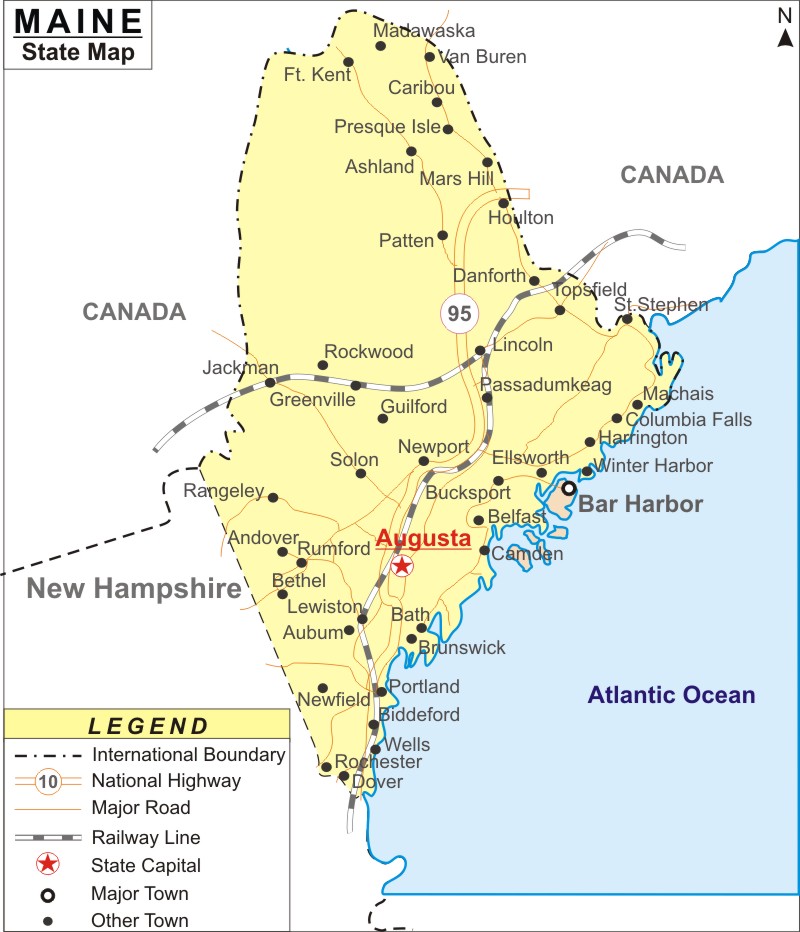
In terms of area, Maine is the 39th biggest state in the U.S. The state of Maine is famous for its exotic seafood, scenic landscapes, mountains, dense jungles, and stony shoreline. The capital of ME is Augusta and largest city is Portland. Maine hotels are tailored for business and leisure tourists. The main airport of ME is Portland International Jetport.
Map of Maine with Cities, Road, River, Highways
 About Map: Maine Map showing the capital, state boundary, roads, rail network,rivers, interstate highways, major cities and towns.
More Maine Maps & Info
| Maine Map | Maine County Map | Map of Maine With Cities |
| Maine Zipcodes | Airports in Maine | Where is Maine |
| Maine Area Codes | Maine Blank Map | Maine River Map |
| US County Map | Maine Physical Map | Maine Road Map |
About Maine State Map
Maine, the 23rd state of the United States, creates a part of the northeastern segment of the country. Its picturesque landscapes, exotic seafood, dense jungles, mountains, and stony shoreline make it a traveler's paradise. The hilly state covers a total area of 35,385 sq miles and shares its borders with New Brunswick and Quebec (Canada), the Atlantic Ocean, and New Hampshire.
A Maine Map will help you move around in the state and locate every important tourist attraction for which the state is famous. The capital of Maine is Augusta and the largest city is Portland.
The Maine Map clearly defines the geographical and political contours of the state. The State of Maine is located in the northeastern part of the United States of America. Maine is surrounded by Canada on its northern border, by New Hampshire on its western and southern border and by the Atlantic Ocean on its eastern border.
Maine encompasses total area of 35,387 square miles, out of which 30,865 square miles is the total land area and 4,523 square miles is the inland water area. Situated at an altitude of 5,276 feet, Mount Katahdin is the highest point of Maine. The Atlantic Ocean is the lowest point of the state of Maine. Kennebec River, St. John River, Androscoggin River and Penobscot River are the major rivers of the State of Maine.
Richardson Lake and Moosehead Lake are the prominent lakes of Maine. The geographical divisions of the mountains, piedmont, uplands and coastal lowlands characterize the heterogeneous topography of the state. The map of Maine indicates the important cities of the state.
Augusta is the capital of the State of Maine. Caribou, Bangor, Lewiston, Kennebunk, Cape Elizabeth and South Berwick are some of the prominent cities of Maine. The Maine State Map points out the exact geographical location of the state.
Maine Interstates
North-South interstates include: Interstate 15, Interstate 17 and Interstate 19. East-West interstates include: Interstate 8, Interstate 10 and Interstate 40.
Maine Routes
US Highways and State Routes include: Route 60, Route 70, Route 89, Route 89A, Route 93, Route 95, Route 160, Route 180 and Route 191.
Maine State Facts
| State Name | Maine |
| Capital City | Augusta |
| Country | United States |
| Continent | North America |
| Largest city | Portland |
| Abbreviation | ME, US-ME |
| Joined the Union | March 15, 1820 (23rd) |
| Nickname | Pine Tree State |
| Area | 35,385 sq mi (91,646 km2) |
| Timezone | Eastern: UTC −5/−4 |
| Population | 1,328,302 (2013 est) |
| Highest Point | Mount Katahdin |
| Lowest Point | Atlantic Ocean |
| Official Website | https://www.maine.gov/ |
- Where is Akron
- Where is Anaheim
- Where is Anchorage
- Where is Arlington
- Where is Aurora
- Where is Baltimore
- Where is Baton Rouge
- Where is Birmingham
- Where is Boise City
- Where is Boston
- Where is Buffalo
- Where is Chandler
- Where is Charlotte
- Where is Chesapeake
- Where is Chula Vista
- Where is Cincinnati
- Where is Cleveland
- Where is Colorado Springs
- Where is Columbus
- Where is Corpus Christi
- Where is Des Moines
- Where is Detroit
- Where is Durham
- Where is El Paso
- Where is Fayetteville
- Where is Fort Wayne
- Where is Freemont
- Where is Fresno
- Where is Garland
- Where is Gilbert
- Where is Glendale
- Where is Greensboro
- Where is Henderson
- Where is Hialeah
- Where is Honolulu
- Where is Houston
- Where is Indianapolis
- Where is Irvine
- Where is Irving
- Where is Jacksonville
- Where is Jersey City
- Where is Kansas City
- Where is Laredo
- Where is Lincoln
- Where is Long Beach
- Where is Louisville
- Where is Lubbock
- Where is Madison
- Where is Memphis
- Where is Mesa
- Where is Milwaukee
- Where is Minneapolis
- Where is Modesto
- Where is Montgomery
- Where is Nashville
- Where is Newark
- Where is Norfolk
- Where is North Las Vegas
- Where is Oakland
- Where is Oklahoma City
- Where is Omaha
- Where is Orlando
- Where is Paradise
- Where is Philadelphia
- Where is Phoenix
- Where is Portland
- Where is Raleigh
- Where is Reno
- Where is Richmond
- Where is Riverside
- Where is Rochester
- Where is Sacramento
- Where is Saint Paul
- Where is Saint Petersburg
- Where is San Bernardino
- Where is San Jose
- Where is Santa Ana
- Where is Scottsdale
- Where is Shreveport
- Where is Spokane
- Where is St Louis
- Where is Stockton
- Where is Tampa
- Where is Toledo
- Where is Tucson
- Where is Tulsa
- Where is Virginia Beach
- Where is Wichita
