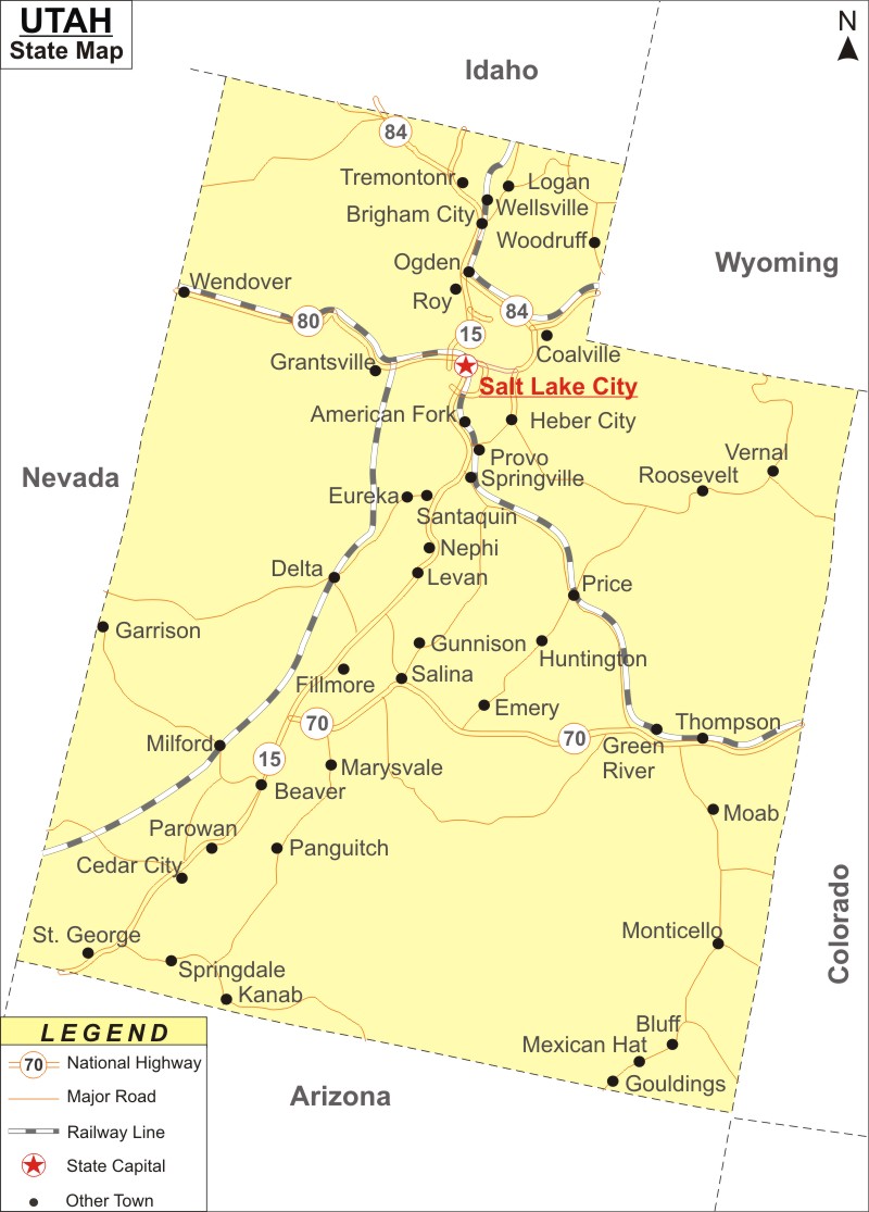
Utah Map: Utah is a state in the Mountain West subregion of the Western United States. Utah is the the 30th-most-populous, 11th-least-densely populated and 13th largest U.S. state by area. It covers an area of 84,899 sq mi (219,887 km2), with population of 3,271,616 residents as of 2020 Census.
Map of Utah with Cities, Road, River, Highways
 About Map: Utah Map showing the capital, state boundary, roads, rail network,rivers, interstate highways, major cities and towns.
Utah More Maps & Info
| Where is Utah | Counties in Utah | Cities in Utah |
| Utah Zipcodes | Airports in Utah | US Zip code Map |
| Utah Area Codes | Utah River Map | - |
About Utah State Map
Utah is a state located in the Mountain West region of the Western United States. It shares borders with Colorado to the east, Wyoming to the northeast, Idaho to the north, Arizona to the south, and Nevada to the west. In the southeast, Utah also touches a portion of New Mexico. Utah is the eleventh least densely inhabited of the fifty states in the United States and is the thirteenth largest by area with a population of over three million. The capital city of Utah is Salt Lake City. All these borders can be seen in the Utah map in a crystal clear manner.
Utah Map
The detailed Utah map displays the boundaries of the US state of Utah, the location of Salt Lake City, the state capital, as well as significant cities and other populous areas, rivers and lakes, interstate highways, major highways, and railroads.
Utah Map Illustrates Major Cities
Utah map also shows the major cities as well as the towns of the state. Cities like Salt Lake City, Provo, Ogden, Park City, St. George, Orem, American Fork, Beaver, Blanding, Bluff, Cedar City, Coalville, Delta, Duchesne, Bountiful, Brigham City, Castle Dale, Hurricane, Junction, Kanab, Layton, Loa, River, Gunnison, Hanksville, Heber City, Mt Pleasant, Murray, Nephi, Panguitch, Roosevelt, Roy, Sandy, Tooele, Torrey, Logan, Milford, Moab, Monticello, Morgan, Roosevelt, Roy, Sandy, Tooele, Torrey, Vernal, Wendover, West Valley City, Woodruff, Parowan, Price, Randolph, and Richfield can be located in Utah map.
Utah Map Indicates National Highways & Routes of the State
The Utah map shows every National Highway and Route because they make up the state's transportation system. Below are the details of National Highways and Routes.
Facts About Utah
| State Name | Utah |
| Country | United States |
| Continent | North America |
| Capital City | Salt Lake City |
| Largest city | Salt Lake City |
| Abbreviation | UT, US-UT |
| Joined the Union | January 4, 1896 (45th) |
| Nickname | Beehive State |
| Area | 84,899 sq mi (219,887 km2) - Rank 13th |
| Timezone | Mountain: UTC −7/−6 |
| Population (2020) | 3,271,616 - Rank 30th |
| Highest Point | Kings Peak |
| Lowest Point | Beaver Dam Wash |
| Official Website | www.utah.gov |
