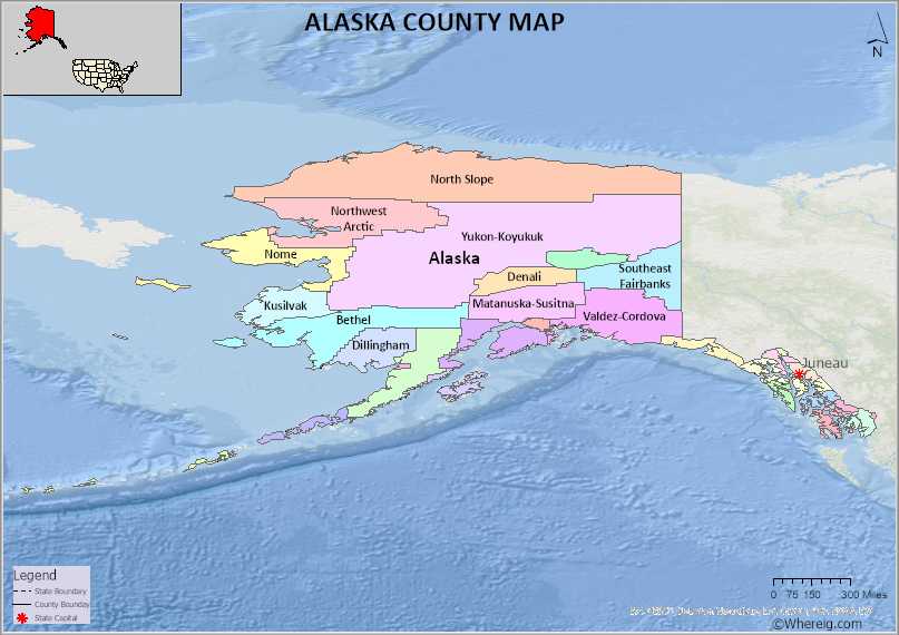
The U.S. state of Alaska is divided into 19 Borough. Explore the Alaska Borough Map, list of Boroughs in Alaska along with their County Seats in alphabetical order along with their population, areas and the date of formation.
Alaska County Map
 About Alaska County Map: The map showing the county boundary, all counties boundary, state capital and neighbouring states.
About Alaska Borough
Alaska is located at the extreme northwest of North American continent. In fact, Alaska Peninsula is the biggest peninsula in the western Hemisphere. Since 180th meridian goes through one of the islands of Alaska namely Aleutian Islands, Westernmost part is in Eastern Hemisphere. Hence, we can technically say that Alaska lies in both Hemispheres. The state of Alaska is bordered by Canada to the east, the Pacific Ocean to the south, Chukchi Sea to the west and Arctic Ocean to the north. Alaska is the center point that connects North America with Asia by air or sea.
TThe state of Alaska means Great Land. The nickname of Alaska is Last Frontier. The state Capital is located in the southeast province of Alaska which is known as Juneau. There are 17 mountain peaks in Alaska. one of the amazing things about Alaska is, it has got 100 volcanoes. Indeed, the people of Alaska are blessed with 3000 rivers and 3,000,000 lakes. The largest of them is Lake Iliamna. Unlike other states of U.S, Alaska is not divided into counties. The state of Alaska is divided into boroughs. They are 19 organized boroughs and one unorganized borough. Alaska has got 144 cities all in all. The total land area of Alaska is 570641 square meters, which accounts for 1477953 square kilometers. The population of Alaska is expected to reach 734 thousand this year.
With regarding the administration, Alaska follows federal government as it is followed at the central level and it has three branches of government. They are state Legislature, executive and the judiciary system. Alaska has got two levels of local government. The city and borough. Borough is similar to county. Cities are divided into home rule and first-class Second-class cities. Same thing with borough as well, they are also divided into home rule and first class, second- and third-class boroughs.
The U.S. state of Alaska has 19 Boroughs. Explore list of Alaska Counties and County Seats in alphabetical order and check their population, areas and the date of formation.
List of Boroughs in Alaska and County Seats
| Borough | FIPS Code | Borough seat | Formed | Population | Area |
|---|---|---|---|---|---|
| Aleutians East Borough | 13 | Sand Point | 1987 | 3,420 | 6,985 sq (18,091 km2) |
| Anchorage | 20 | Consolidated city-borough | 1964/1975 | 291,247 | 1,707 sq (4,421 km2) |
| Bristol Bay Borough | 60 | Naknek | 1962 | 844 | 482 sq (1,248 km2) |
| Denali Borough | 68 | Healy | 1990 | 1,619 | 12,641 sq (32,740 km2) |
| Fairbanks North Star Borough | 90 | Fairbanks | 1964 | 95,655 | 7,335 sq (18,998 km2) |
| Haines Borough | 100 | Consolidated city-borough | 1968 | 2,080 | 2,343 sq (6,068 km2) |
| Juneau | 110 | Consolidated city-borough | 1970 | 32,255 | 2,704 sq (7,003 km2) |
| Kenai Peninsula Borough | 122 | Soldotna | 1964 | 58,799 | 16,017 sq (41,484 km2) |
| Ketchikan Gateway Borough | 130 | Ketchikan | 1963 | 13,948 | 4,857 sq (12,580 km2) |
| Kodiak Island Borough | 150 | Kodiak | 1963 | 13,101 | 6,689 sq (17,324 km2) |
| Lake and Peninsula Borough | 164 | King Salmon | 1989 | 1,476 | 23,832 sq (61,725 km2) |
| Matanuska-Susitna Borough | 170 | Palmer | 1964 | 107,081 | 24,707 sq (63,991 km2) |
| North Slope Borough | 185 | Utqiaġvik | 1972 | 11,031 | 88,824 sq (230,053 km2) |
| Northwest Arctic Borough | 188 | Kotzebue | 1986 | 7,793 | 35,663 sq (92,367 km2) |
| Petersburg Borough | 195 | Petersburg | 2013 | 3,398 | 2,901 sq (7,514 km2) |
| Sitka | 220 | Consolidated city-borough | 1971 | 8,458 | 2,870 sq (7,433 km2) |
| Skagway | 230 | Consolidated city-borough | 2007 | 1,240 | 434 sq (1,124 km2) |
| Unorganized Borough | - | - | 1961 | 77,157 | 319,852 sq (828,413 km2) |
| Wrangell | 275 | Consolidated city-borough | 2008 | 2,127 | 2,556 sq (6,620 km2) |
| Yakutat | 282 | Consolidated city-borough | 1992 | 662 | 7,623 sq (19,743 km2) |
- Alabama Counties
- Alaska boroughs
- Arizona Counties
- Arkansas Counties
- California County Map
- Colorado Counties
- Connecticut Counties
- Delaware Counties
- Florida County Map
- Georgia County Map
- Hawaii Counties
- Idaho Counties
- Illinois Counties
- Indiana Counties
- Iowa Counties
- Kansas Counties
- Kentucky Counties
- Louisiana Counties
- Maine Counties
- Maryland Counties
- Massachusetts Counties
- Michigan County Map
- Minnesota Counties
- Mississippi Counties
- Missouri Counties
- Montana Counties
- Nebraska Counties
- New Hampshire Counties
- New Jersey Counties
- New Mexico Counties
- North Carolina Counties
- North Dakota Counties
- Oklahoma Counties
- Oregon Counties
- Pennsylvania Counties
- Rhode Island Counties
- South Carolina Counties
- South Dakota Counties
- Map of Tennessee
- Texas County Map
- Utah Counties
- Vermont Counties
- Virginia Counties
- Washington Counties
- West Virginia Counties
- Wisconsin Counties
- Wyoming Counties
- Nevada Counties
- New York Counties
- Ohio County Map
