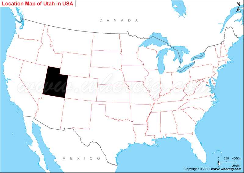
Where is Utah State Located?
As shown in the given Utah location map that Utah is located in the western part of the United States. Utah map also illustrates that the state shares border with Colorado in the east, Wyoming in the north-east, Idaho in the north, Nevada in the west, Arizona in the south, and New Mexico in the south-east. Utah is the 45th state that admitted in the Jurisdiction of the United States. Interestingly, the state name 'Utah' is derived from the Ute tribe language, which means people of the mountains.
The climate of state varies from semi-arid to arid. In spite of this, Utah is important tourist place. The state has several national parks with beautiful natural landscapes. Above all, the Salt Lake is also point of attraction for the tourists.
Moreover, as per the report - the state Utah is a center of information technology, transportation, research, government services, and mining. In addition, it is also the major tourist destination for outdoor recreation.
Utah State - Quick Facts
| Country: | United States |
| Region Type: | State |
| Capital: | Salt Lake City |
| Abbreviation: | UT, US-UT |
| Largest City: | Salt Lake City |
| Area: | 84,899 sq mi (219,887 km2) |
| Population: | 2,900,872 (2013 est) |
| Joined The Union: | -1456 |
| Nickname: | Beehive State |
| Highest Point: | Kings Peak |
| Lowest Point: | Beaver Dam Wash |
| Timezone: | Mountain: UTC −7/−6 |
| Official Website: | www.utah.gov |
Location Map of USA with States
- Where is Alabama (AL)
- Where is Alaska
- Where is Arizona
- Where is Arkansas Location Mapp
- Where is California
- Where is Colorado
- Where is Connecticut
- Where is Delaware
- Where is Florida
- Where is Georgia
- Where is Hawaii
- Where is Idaho State Map
- Where is Illinois
- Where is Indiana
- Where is Iowa
- Where is Kansas
- Where is Kentucky
- Where is Louisiana
- Where is Maine
- Where is Maryland
- Where is Massachusetts
- Where is Michigan
- Where is Minnesota
- Where is Mississippi
- Where is Missouri
- Where is Montana
- Where is Nebraska
- Where is Nevada
- Where is New Hampshire
- Where is New Jersey
- Where is New Mexico
- Where is New York
- Where is North Carolina
- Where is North Dakota
- Where is Ohio
- Where is Oklahoma
- Where is Oregon
- Where is Pennsylvania
- Where is Rhode Island
- Where is South Carolina
- Where is South Dakota
- Where is Tennessee
- Where is Texas
- Where is Utah
- Where is Vermont
- Where is Virginia
- Where is Washington
- Where is West Virginia
- Where is Wisconsin
- Where is Wyoming


