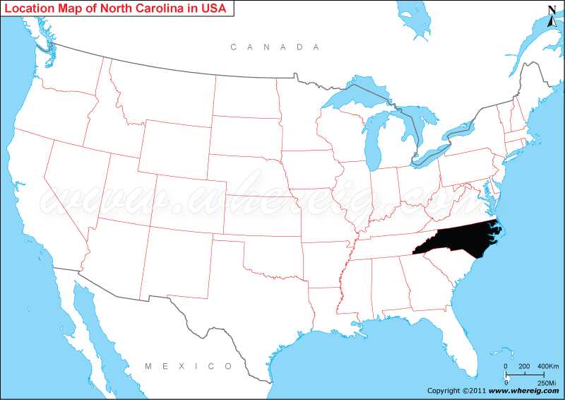
Map showing location of North Carolina Located?
The capital city of state is Raleigh; however, the largest city is Charlotte. The climate type of state is largely humid sub-tropical type.
The important economic sectors of the state are agriculture, financial services, and manufacturing. Important agricultural produce are tobacco, hogs, milk, nursery stock, sweet potatoes, soybeans, cattle, and poultry and eggs. And, the important industries are textiles, chemicals, electrical equipment, paper and pulp and paper products.
North Carolina More Maps & Info
Where is North Carolina Located
As shown in the given North Carolina location map that North Carolina is located in the south-eastern region of the United States. North Carolina map also shows that the state shares its boundary with Virginia in the north, Tennessee in the west, Georgia in the south-west, and South Carolina in the south. Besides, Atlantic Ocean lies in the east of the state.The capital city of state is Raleigh; however, the largest city is Charlotte. The climate type of state is largely humid sub-tropical type.
The important economic sectors of the state are agriculture, financial services, and manufacturing. Important agricultural produce are tobacco, hogs, milk, nursery stock, sweet potatoes, soybeans, cattle, and poultry and eggs. And, the important industries are textiles, chemicals, electrical equipment, paper and pulp and paper products.
North Carolina State - Quick Facts
| Country: | United States |
| Region Type: | State |
| Capital: | Raleigh |
| Abbreviation: | NC, US-NC |
| Largest City: | Charlotte |
| Area: | 53,819 sq mi (139,390 km2) |
| Population: | 10,439,388 (2020 Census) |
| Joined The Union: | -40215 |
| Nickname: | Tar Heel State, Old North State |
| Highest Point: | Mount Mitchell |
| Lowest Point: | Atlantic Ocean |
| Timezone: | UTC -5/-4 |
| Official Website: | www.nc.gov |
Location Map of USA with States
- Where is Alabama (AL)
- Where is Alaska
- Where is Arizona
- Where is Arkansas Location Mapp
- Where is California
- Where is Colorado
- Where is Connecticut
- Where is Delaware
- Where is Florida
- Where is Georgia
- Where is Hawaii
- Where is Idaho State Map
- Where is Illinois
- Where is Indiana
- Where is Iowa
- Where is Kansas
- Where is Kentucky
- Where is Louisiana
- Where is Maine
- Where is Maryland
- Where is Massachusetts
- Where is Michigan
- Where is Minnesota
- Where is Mississippi
- Where is Missouri
- Where is Montana
- Where is Nebraska
- Where is Nevada
- Where is New Hampshire
- Where is New Jersey
- Where is New Mexico
- Where is New York
- Where is North Carolina
- Where is North Dakota
- Where is Ohio
- Where is Oklahoma
- Where is Oregon
- Where is Pennsylvania
- Where is Rhode Island
- Where is South Carolina
- Where is South Dakota
- Where is Tennessee
- Where is Texas
- Where is Utah
- Where is Vermont
- Where is Virginia
- Where is Washington
- Where is West Virginia
- Where is Wisconsin
- Where is Wyoming


