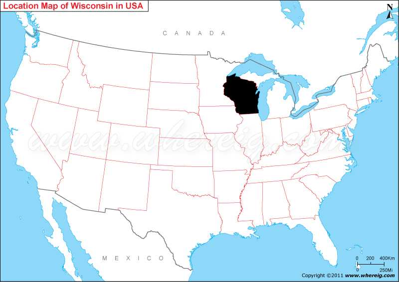
Wisconsin is located in the north-central, Great Lakes and Midwest regions of the United States. It lies at a latitude of 43.7844° N and a longitude of 88.7879° W.
Location Map of Wisconsin State

Most Viewed Links
| Wisconsin Map | Counties in Wisconsin |
| Wisconsin Zipcodes | Airports in Wisconsin |
| Wisconsin Area Codes | Cities in Wisconsin |
| Where is Madison | Where is Milwaukee |
Where is Wisconsin Located?
As shown in the given Wisconsin location map that Wisconsin is located in the north part of the United States; however, it is considered as the part of the Midwest. Wisconsin shares its border with Minnesota in the west, Iowa in the south-west, Illinois in the south, Michigan in the northeast. Besides, it also shares water areas with Great Lakes Superior and Michigan.
Wisconsin is the 23rd-largest state by total area and the 20th-most populous state in the US. The capital city of Wisconsin is Madison; however, the largest city is Milwaukee. The climate type of Wisconsin is humid continental. The state name 'Wisconsin’ is derived from the name of Wisconsin River. In fact, this name was first used by one of the Algonquian speaking American Indian groups.
Moreover, the state is one of the most visited tourist destinations that receives thousands of tourists every year. Milwaukee is one of the favorite tourist cities of Wisconsin.
Wisconsin State Facts
| Wisconsin Location: | North-central United States |
| Wisconsin Coordinates: | 43.7844° N, 88.7879° W |
| Country: | United States |
| Region Type: | State |
| Capital: | Madison |
| Abbreviation: | WI, Wis. US-WI |
| Largest City: | Milwaukee |
| Area: | 65,497.82 sq mi (169,639 km2) |
| Population: | 5,893,718 [20th] (2020 Census) |
| Pop. Density: | 105/sq mi (40.6/km2) |
| Joined The Union: | May 29, 1848 (30th) |
| Nickname: | Badger State, America's Dairyland |
| Highest Point: | Timms Hill 1,951 ft (595 m) |
| Lowest Point: | Lake Michigan 579 ft (176 m) |
| Timezone: | Central: UTC −6/−5 |
| Official Website: | www.wisconsin.gov |
- Where is Akron
- Where is Anaheim
- Where is Anchorage
- Where is Arlington
- Where is Aurora
- Where is Baltimore
- Where is Baton Rouge
- Where is Birmingham
- Where is Boise City
- Where is Boston
- Where is Buffalo
- Where is Chandler
- Where is Charlotte
- Where is Chesapeake
- Where is Chula Vista
- Where is Cincinnati
- Where is Cleveland
- Where is Colorado Springs
- Where is Columbus
- Where is Corpus Christi
- Where is Des Moines
- Where is Detroit
- Where is Durham
- Where is El Paso
- Where is Fayetteville
- Where is Fort Wayne
- Where is Freemont
- Where is Fresno
- Where is Garland
- Where is Gilbert
- Where is Glendale
- Where is Greensboro
- Where is Henderson
- Where is Hialeah
- Where is Honolulu
- Where is Houston
- Where is Indianapolis
- Where is Irvine
- Where is Irving
- Where is Jacksonville
- Where is Jersey City
- Where is Kansas City
- Where is Laredo
- Where is Lincoln
- Where is Long Beach
- Where is Louisville
- Where is Lubbock
- Where is Madison
- Where is Memphis
- Where is Mesa
- Where is Milwaukee
- Where is Minneapolis
- Where is Modesto
- Where is Montgomery
- Where is Nashville
- Where is Newark
- Where is Norfolk
- Where is North Las Vegas
- Where is Oakland
- Where is Oklahoma City
- Where is Omaha
- Where is Orlando
- Where is Paradise
- Where is Philadelphia
- Where is Phoenix
- Where is Portland
- Where is Raleigh
- Where is Reno
- Where is Richmond
- Where is Riverside
- Where is Rochester
- Where is Sacramento
- Where is Saint Paul
- Where is Saint Petersburg
- Where is San Bernardino
- Where is San Jose
- Where is Santa Ana
- Where is Scottsdale
- Where is Shreveport
- Where is Spokane
- Where is St Louis
- Where is Stockton
- Where is Tampa
- Where is Toledo
- Where is Tucson
- Where is Tulsa
- Where is Virginia Beach
- Where is Wichita
Written and fact-checked by Whereig.com Web Team | Last Updated: January 18, 2025, 11:50 AM ET
