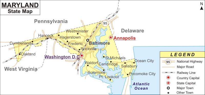
Maryland, a state is in the Mid Atlantic region of the USA. It is bordered by Virginia, West Virginia, the District of Columbia, Pennsylvania and Delaware.
Map of Maryland with Cities, Road, River, Highways
 About Map: Maryland Map showing the capital, state boundary, roads, rail network,rivers, interstate highways, major cities and towns.
More Maryland Maps & Info
About Maryland State Map
Situated on the eastern coastline of the South Atlantic part of the USA (United States of America),The Map Of Maryland covers a total area of 12,406.68 square miles . The state is sub divided into 24 counties, which are each governed by county seats. The Interstate Highways of 95, 83, 81, 695, 97 and 495 connect the northern and southern part of Maryland. The eastern end is joined to the western end of Maryland by the Interstate Highways of 70, 270 and 68. CSX Transportation and Canton Railroads are some of the major companies that providing rail services in Maryland. The Patapsco, Susquehanna, Patuxent and Potomac rivers are a few of the major rivers of Maryland.
The state boasts many golfing destinations in Berlin, Easton and Baltimore. Catoctin Mountain Park and Antietam National Battlefield are some national parks in the state. Some of the famous museums are the National Capital Trolley Museum and Sandy Spring Museum.
Maryland State Information
| State Name | Maryland |
| Country | United States |
| Continent | North America |
| Capital City | Annapolis |
| Largest city | Baltimore |
| Abbreviation | MD, US-MD |
| Joined the Union | April 28, 1788 (7th) |
| Nickname | Old Line State |
| Area | 12,407 sq mi (32,133 km2) |
| Timezone | Eastern: UTC −5/−4 |
| Population | 5,928,814 (2013 est) |
| Highest Point | Hoye-Crest |
| Lowest Point | Atlantic Ocean |
| Official Website | www.maryland.gov |
- Where is Annapolis
- Where is Aspen Hill
- Where is Bel Air North
- Where is Bel Air South
- Where is Baltimore
- Where is Bethesda
- Where is Bowie
- Where is Carney
- Where is Catonsville
- Where is Chillum
- Where is Clarksburg
- Where is Clinton
- Where is College Park
- Where is Columbia
- Where is Crofton
- Where is Dundalk
- Where is Eldersburg
- Where is Elkridge
- Where is Ellicott City
- Where is Essex
- Where is Frederick
- Where is Gaithersburg
- Where is Germantown
- Where is Glen Burnie
- Where is Hagerstown
- Where is Laurel
- Where is Middle River
- Where is Milford Mill
- Where is Montgomery Village
- Where is North Bethesda
- Where is North Laurel
- Where is Odenton
- Where is Olney
- Where is Owings Mills
- Where is Parkville
- Where is Pasadena
- Where is Perry Hall
- Where is Pikesville
- Where is Potomac
- Where is Randallstown
- Where is Rockville
- Where is Salisbury
- Where is Severn
- Where is Severna Park
- Where is Silver Spring
- Where is South Laurel
- Where is Towson
- Where is Waldorf
- Where is Wheaton
- Where is Woodlawn
