
Tennessee is the 36th largest state in the U.S. The capital is Nashville and biggest city is Memphis. The state of Tennessee is popular for its national parks, mountains, and rivers. The state is bordered by Georgia, Alabama, and Mississippi to the south, Kentucky to the north, Virginia to the northeast, North Carolina to the east, Arkansas to the west, and Missouri to the northwest.
Map of Tennessee with Cities, Road, River, Highways
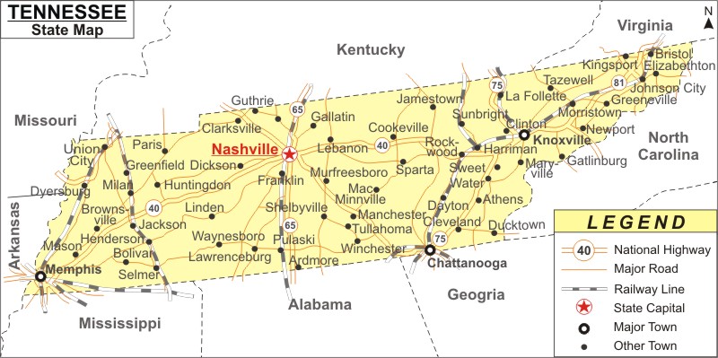 About Map: Tennessee Map showing the capital, state boundary, roads, rail network,rivers, interstate highways, major cities and towns.
Tennessee More Maps & Info
About Tennessee State Map
Tennessee is a landlocked state located in the Southeastern part of the United States. In terms of area, the state ranks 36th and regarding population, Tennessee ranks 15th out of the 50 states. It shares borders with Kentucky to the north, Virginia to the northeast, North Carolina to the east, Georgia, Alabama, and Mississippi to the south, Arkansas to the southwest, and Missouri to the northwest. East, Middle, and West Tennessee are the three Grand Divisions of Tennessee in terms of geography, culture, and law. The state's largest city, Nashville, serves as both the capital and the hub of its major metropolitan region. All these borders are clearly indicated by the map of Tennessee. A Tennessee Map is an indispensable guide to know this scenic and mountainous state. The capital of TN is Nashville and the largest city is Memphis.
Tennessee Map:
The detailed map of Tennessee shows the state's boundaries, the location of the state capital, Nashville City, major cities and other populated areas, rivers and lakes, significant highways, interstates, railroads, and airports, as well as other geographical features. The Tennessee map on this page can be used for educational as well as non-educational purposes. You can get it for free by downloading it.
Tennessee Map Indicates Major Cities
The major cities of Tennessee are shown in the Tennessee map. The major cities of the state are Memphis, Knoxville, Chattanooga, Clarksville ,Athens, Bolivar, Bristol, Brownsville, Cleveland, Columbia, Cookeville, Gallatin, Gatlinburg, Germantown, Greeneville, Hendersonville, Jackson, Johnson City, Dickson, Dyersburg, Fayetteville, Franklin, Jackson, Johnson City, Kingsport, Lawrenceburg, Lebanon, Lexington, Linden, Livingston, Oneida, Paris, Portland, Pulaski, Savannah, Selmer, Shelbyville, Smyrna, Tullahoma, Union City, and Waverly, Martin, Maryville, McMinnville, Milan, Millington, Morristown and Newport.
Tennessee Map Displays National Highways & Routes of the State
Tennessee map includes all of the National Highways and Routes because they make up the state's transportation system. Information regarding national highways and routes is provided below.
Tourist attractions in Tennessee:
A Tennessee Map will assist you to find out all the top-rated tourist attractions in the state like the following:
- Great Smoky Mountains National Park - Gatlinburg
- Graceland - Memphis
- Dollywood - Pigeon Forge
- Grand Ole Opry - Nashville
- Country Music Hall of Fame - Nashville
- Lookout Mountain - Chattanooga
- Gatlinburg SkyPark - Gatlinburg
- Pigeon Forge Parkway - Pigeon Forge
- Sun Studio - Memphis
- Ruby Falls - Chattanooga
- Ryman Auditorium - Nashville
- Beale Street - Memphis
Tennessee State Facts
| Particular | Details |
|---|---|
| State Name | Tennessee |
| Nickname | The Volunteer State |
| Country | United States |
| Continent | North America |
| Capital City | Nashville |
| Largest City | Nashville |
| Abbreviation | TN, Tenn., US-TN |
| State Motto | Agriculture and Commerce |
| Bordering States | Kentucky, Virginia, North Carolina, Georgia, Alabama, Mississippi, Arkansas, Missouri |
| State Flower | Iris |
| State Bird | Northern Mockingbird |
| State Animal | Raccoon |
| Joined the Union | June 1, 1796 (16th) |
| Area | 42,143 sq mi (109,247 sq km) - Rank 36th |
| Major Cities | Nashville, Memphis, Knoxville, Chattanooga, Clarksville |
| Timezone | UTC -6 (CST) / UTC -5 (EST) |
| Population | 6,910,840 (2020 Census) - Rank 15th |
| Highest Point | Clingmans Dome - 6,643 ft (2,025 m) |
| Lowest Point | Mississippi River - 178 ft (54 m) |
| Major Rivers |
|
| Major Lakes | Kentucky Lake, Norris Lake, Cherokee Lake, Center Hill Lake |
| Longest River | Tennessee River |
| National Parks |
|
| Famous For | Country music, Great Smoky Mountains, whiskey distilleries, blues music, Graceland |
| Airports | Nashville (BNA), Memphis (MEM), Knoxville (TYS), Chattanooga (CHA) |
| Major Sports Team | 1 NFL, 1 NBA, 1 NHL, 1 MLS teams |
| Governor | Bill Lee (as of 2025) |
| Major Highways | U.S. Highway 11, U.S. Highway 41, U.S. Highway 64, U.S. Highway 70, U.S. Highway 72 |
| Interstate Highways | I-24, I-26, I-40, I-55, I-65, I-75, I-81, I-155, I-240, I-275, I-640, I-840 |
| State Routes | SR 1, SR 33, SR 52, SR 96, SR 100, SR 109, SR 155, SR 385 |
| Official Website | www.tn.gov |
List of the Largest Cities in Tennessee by Population
| City | County | Population (2020 Census) | Lat Long |
|---|---|---|---|
| Nashville | Davidson County | 689,447 | 36.1627°N, 86.7816°W |
| Memphis | Shelby County | 633,104 | 35.1495°N, 90.0490°W |
| Knoxville | Knox County | 190,740 | 35.9606°N, 83.9207°W |
| Chattanooga | Hamilton County | 181,099 | 35.0456°N, 85.3097°W |
| Clarksville | Montgomery County | 166,722 | 36.5298°N, 87.3595°W |
| Murfreesboro | Rutherford County | 152,769 | 35.8456°N, 86.3903°W |
| Franklin | Williamson County | 83,454 | 35.9251°N, 86.8689°W |
| Jackson | Madison County | 68,205 | 35.6145°N, 88.8139°W |
| Johnson City | Washington County | 71,046 | 36.3134°N, 82.3535°W |
| Bartlett | Shelby County | 57,786 | 35.2045°N, 89.8739°W |
Regions in Tennessee
- East Tennessee
- Middle Tennessee
- West Tennessee
- Cumberland Plateau
- Great Smoky Mountains
- Tennessee Valley
National Parks in Tennessee
- Great Smoky Mountains National Park
- Big South Fork National River and Recreation Area
- Andrew Johnson National Historic Site
- Obed Wild and Scenic River
- Shiloh National Military Park