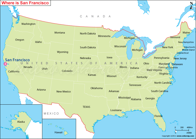
Where is San Francisco, CA?
The San Francisco location map shows that San Francisco is located at the eastern Pacific coast in the south-western region of the United States. In the south-western region, San Francisco is the financial, transportation, and cultural center. Interestingly, in the year 1776, the Spanish established a fort at the Golden Gate and for Francis of Assisi on the site. However, during the period of California Gold Rush in the year 1848 increased the city growth swiftly.
Furthermore, at present, San Francisco is a popular international tourist destination known for its summer fog, Today, San Francisco is a popular international tourist destination, renowned for its, eclectic mix of Victorian and modern architecture, chilly summer fog, steep rolling hills, along with some of the well-known landmarks, such as the Golden Gate Bridge, Chinatown, and cable cars. In addition, the city is also a principal banking and financial center, and it homes more than 30 international financial institutions.
San Francisco, California Quick Facts
| Fact | Details |
|---|---|
| City | San Francisco |
| County | City and County of San Francisco |
| State | California |
| State Capital | Sacramento |
| US Region | West |
| Latitude | 37.7749° N |
| Longitude | 122.4194° W |
| Elevation | 52 ft (16 m) |
| Land Area | 46.9 sq mi |
| Water Area | 184.0 sq mi |
| Total Area | 231.0 sq mi |
| Population (2020 Census) | 873,965 |
| Population Density | Approximately 18,635 per sq mi |
| ZIP Codes | 94102, 94103, 94104, 94105, 94107, 94108, 94109, 94110, 94111, 94112, 94114, 94115, 94116, 94117, 94118, 94121, 94122, 94123, 94124, 94127, 94129, 94130, 94131, 94132, 94133, 94134, 94158 |
| Area Code | 415, 628 |
| Time Zone Standard | Pacific Standard Time (PST, UTC-8) |
| Time Zone Daylight | Pacific Daylight Time (PDT, UTC-7) |
| Currency | US Dollar (USD) |
| FIPS Code | 06-67000 |
| Congressional District | California 11th Congressional District |
Location and Surroundings
San Francisco is located on the northern tip of the San Francisco Peninsula in Northern California. It lies between the Pacific Ocean and San Francisco Bay, with Oakland across the Bay Bridge to the east and Marin County across the Golden Gate Bridge to the north. The city is famous for its iconic landmarks, steep hills, cable cars, diverse neighborhoods, and role as a global center for technology, finance, and culture.
Nearby Cities to San Francisco, California
- Daly City, California - 6 mi South
- South San Francisco, California - 9 mi South
- Brisbane, California - 9 mi Southeast
- Oakland, California - 12 mi East
- Berkeley, California - 15 mi Northeast
- San Bruno, California - 12 mi South
- Alameda, California - 15 mi East
- Mill Valley, California - 14 mi North
- San Rafael, California - 18 mi North
- Redwood City, California - 27 mi South
San Francisco, California Climate and Weather Overview
| Month | Avg High (°F) | Avg Low (°F) | Avg Rainfall (in) |
|---|---|---|---|
| January | 58 | 46 | 4.5 |
| April | 63 | 49 | 1.3 |
| July | 68 | 55 | 0.1 |
| October | 71 | 56 | 1.0 |
| Annual | 65 | 51 | 23.0 |
| Climate Attribute | Details |
|---|---|
| Climate Classification (Köppen) | Warm-Summer Mediterranean (Csb) |
| Annual Rainfall | About 23 inches |
| Annual Sunshine Days | Approximately 259 days |
| Hurricane/Tornado Risk | Very low |
| Snowfall | Rare |
Driving Distances from San Francisco, California
| City | State | Distance (mi) | Approx. Drive Time |
|---|---|---|---|
| Daly City | California | 6 | 15 min |
| South San Francisco | California | 9 | 15 min |
| Oakland | California | 12 | 20 min |
| Berkeley | California | 15 | 25 min |
| Mill Valley | California | 14 | 20 min |
| San Rafael | California | 18 | 25 min |
| Redwood City | California | 27 | 35 min |
| San Jose | California | 48 | 50 min |
| Sacramento | California | 87 | 1 hr 30 min |
| Monterey | California | 118 | 2 hr |
Transportation and Connectivity in San Francisco, California
| Category | Details |
|---|---|
| Airport Name | San Francisco International Airport |
| IATA Code | SFO |
| Port | Port of San Francisco |
| Major Highways | US 101, I-80, I-280, CA 1, CA 35 |
| Train/Amtrak Service | Amtrak Thruway, BART, Caltrain |
| Local Bus/Transit Service | San Francisco Municipal Transportation Agency (Muni) |
- US Route 101 - Major north-south route connecting San Francisco with Silicon Valley and the North Coast.
- Interstate 80 - Connects San Francisco with Oakland, Sacramento, and the rest of the Interstate Highway System.
- Interstate 280 - Scenic freeway linking San Francisco with the Peninsula.
- California State Route 1 - Coastal highway serving western San Francisco and the Pacific Coast.
- California State Route 35 - Skyline Boulevard along the Peninsula ridge.
- Bay Bridge and Golden Gate Bridge provide vital regional connections.
Key Landmarks and Places to Visit in San Francisco, California
| Landmark Name | Type |
|---|---|
| Golden Gate Bridge | Landmark Bridge |
| Alcatraz Island | Historic Site |
| Golden Gate Park | Urban Park |
| Fisherman's Wharf | Tourist District |
| Chinatown | Cultural District |
| Palace of Fine Arts | Historic Landmark |
| Coit Tower | Observation Tower |
| Cable Car Museum | Museum |
| Exploratorium | Science Museum |
| Lombard Street | Historic Street |
Waterbodies in San Francisco, California
San Francisco Bay, Pacific Ocean, Golden Gate Strait, Mission Creek, Islais Creek, Lake Merced, Stow Lake, Mountain Lake, Lobos Creek, China Basin
Golf Courses in San Francisco, California
TPC Harding Park, Presidio Golf Course, Lincoln Park Golf Course, Olympic Club Lake Course, Olympic Club Ocean Course, Fleming Golf Course, Golden Gate Park Golf Course, Sharp Park Golf Course, Lake Merced Golf Club, San Francisco Golf Club
Economy and Major Employers in San Francisco, California
| Sector | Major Employer or Industry | Notes |
|---|---|---|
| Technology | Technology and Software Companies | Major driver of the local economy. |
| Finance | Banking and Financial Services | San Francisco is a leading financial center. |
| Healthcare | UCSF Health | One of the region's largest employers. |
| Education | University of California, San Francisco | Globally recognized research institution. |
| Tourism | Hospitality and Visitor Industry | Supports millions of annual visitors. |
| Government | City and County of San Francisco | Major public-sector employer. |
| Biotechnology | Life Sciences Industry | Rapidly growing innovation sector. |
| International Trade | Port and Logistics Operations | Supports regional commerce. |
Colleges and Schools in San Francisco, California
| Institution Name | Type | Level | Notable For |
|---|---|---|---|
| University of California, San Francisco | Public | University | Medical and health sciences research |
| San Francisco State University | Public | University | Comprehensive public education |
| University of San Francisco | Private | University | Jesuit higher education |
| City College of San Francisco | Public | Community College | Academic and workforce programs |
| Golden Gate University | Private | University | Business and law education |
| San Francisco Unified School District | Public | K-12 District | Largest school district in the city |
San Francisco, California - Key Historical Facts
- San Francisco was founded as Yerba Buena in 1776 near a Spanish military presidio and mission.
- The city was renamed San Francisco in 1847, shortly before the California Gold Rush.
- The Gold Rush of 1849 transformed San Francisco into one of the fastest-growing cities in the world.
- The devastating 1906 earthquake and fire destroyed much of the city, leading to a major rebuilding effort.
- During World War II, San Francisco became a critical military and shipbuilding center on the Pacific Coast.
- Today, the city is recognized globally for its innovation, cultural diversity, historic landmarks, and influence on technology and entrepreneurship.
Sources
- Official City and County of San Francisco Website
- Official San Francisco County Government Website
- U.S. Census Bureau
- U.S. Geological Survey (USGS)
- National Weather Service
Most Viewed CA Maps
- Where is Los Angeles
- Where is San Diego
- Where is San Francisco
- Where is Anaheim
- Where is Bakersfield
- Where is Chula Vista
- Where is Freemont
- Where is Fresno
- Where is Glendale
- Where is Irvine
- Where is Long Beach
- Where is Modesto
- Where is Oakland
- Where is Paradise
- Where is Riverside
- Where is Sacramento
- Where is San Bernardino
- Where is San Jose
- Where is Santa Ana
- Where is Stockton
- Where is Berkeley
- Where is Clovis
- Where is Corona
- Where is Elk Grove
- Where is Escondido
- Where is Fontana
- Where is Fremont
- Where is Fullerton
- Where is Garden Grove
- Where is Hayward
- Where is Huntington Beach
- Where is Lancaster
- Where is Moreno Valley
- Where is Oceanside
- Where is Ontario
- Where is Orange
- Where is Oxnard
- Where is Palmdale
- Where is Pasadena
- Where is Pomona
- Where is Rancho Cucamonga
- Where is Roseville
- Where is Salinas
- Where is Santa Clara
- Where is Santa Clarita
- Where is Santa Rosa
- Where is Sunnyvale
- Where is Thousand Oaks
- Where is Torrance
- Where is Vallejo
- Where is Victorville
- Where is Visalia