
Where is Santa Rosa Located? - Santa Rosa is a city located in the Sonoma County of California, United States. Santa Rosa lies between 39.6012 Degrees North latitudes and 105.1507 Degrees West longitudes.
Location Map of Santa Rosa, California
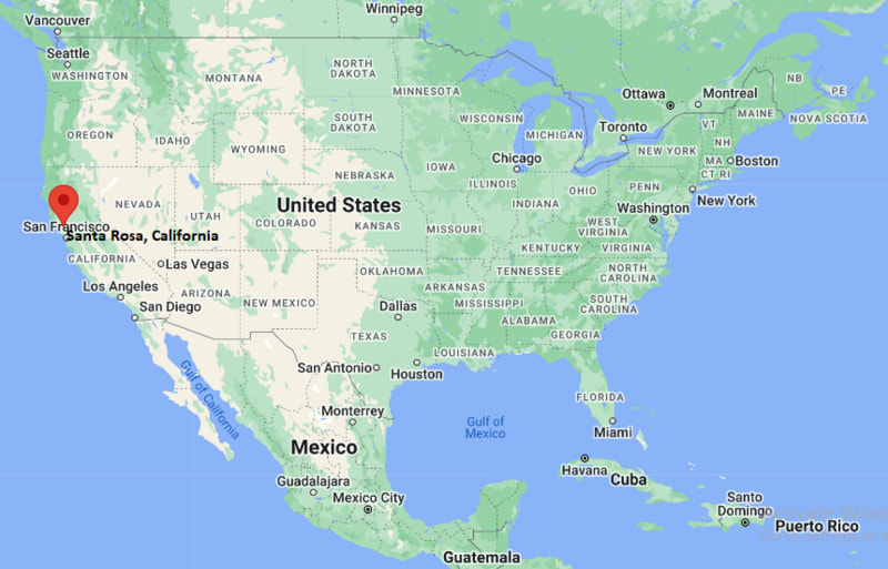
Santa Rosa Map, California, USA
Where is Santa Rosa?: The Google Map showing the location of Santa Rosa in the U.S. state of California.
Where is Santa Rosa Located?
Santa Rosa is a city located in the Sonoma County of California, United States. Santa Rosa lies between 39.6012 Degrees North latitudes and 105.1507 Degrees West longitudes. According to 2020 U.S.census, the population of Santa Rosa city is 178127 people and the city has a total area of 42.52 sq mi. The city has numerous parks and recreational facilities.
Most Viewed US Maps
| USA Sttae Map | USA Region Map | USA Road Map |
| USA County Map | Where is USA in World Map? | US ZIP Code Map |
| USA Time Zones Map | US State and Capitals Map | USA Physical Map |
Find 4,400+ U.S. Cities by State - Explore Their Locations and Get Detailed Information
Santa Rosa City Facts California
| City | Santa Rosa |
| State | California |
| Country | United States |
| County | Sonoma County |
| Founded | 1833 |
| Incorporated | March 26, 1868 |
| Named After | Saint Rose of Lima |
| Nickname | The City of Natural Beauty |
| Population (2025 estimate) | 178,000 |
| Total Area | 41.5 square miles |
| Elevation | 167 feet |
| Time Zone | Pacific Time (PT), UTC −8 (Standard), UTC −7 (Daylight Saving) |
| Latitude | 38.44° N |
| Longitude | 122.71° W |
| Coordinates | 38.44°N, 122.71°W |
| ZIP Codes | 95401, 95403, 95404, 95405, 95407, 95409 |
| Area Codes | 707 |
| Official Language | English |
| Currency | United States Dollar (USD) |
| Major University | Sonoma State University (nearby) |
| Known For | Wine country gateway, parks, arts and culture |
| Climate | Mediterranean climate |
| Nearby Cities | Rohnert Park, Sebastopol, Windsor, Petaluma |
| Main Attractions | Charles M. Schulz Museum, Spring Lake Regional Park, Railroad Square |
| Official Website | https://www.srcity.org |
Transportation and Connectivity in Santa Rosa, California
| Transportation Type | Details |
|---|---|
| Airport Name | Charles M. Schulz–Sonoma County Airport / San Francisco International Airport |
| IATA Code | STS / SFO |
| Port | Port of Oakland / Port of San Francisco (Regional Access) |
| Major Highways | U.S. Highway 101, State Route 12, State Route 1 (Regional) |
| Train Service | Sonoma-Marin Area Rail Transit (SMART) |
| Local Bus/Transit Service | Santa Rosa CityBus and Sonoma County Transit |
- U.S. Highway 101: Major north-south route connecting Santa Rosa with San Francisco, Marin County, and communities throughout the North Bay.
- State Route 12: Provides east-west access through Sonoma County and connects Santa Rosa with the Napa Valley and the Sonoma Valley.
- SMART: Passenger rail service connects Santa Rosa with Sonoma and Marin County communities.
- Charles M. Schulz–Sonoma County Airport: Provides commercial air service for Santa Rosa and the North Bay region.
Top Places to Visit in Santa Rosa, California
| Landmark Name | Type |
|---|---|
| Charles M. Schulz Museum and Research Center | Museum and Cultural Attraction |
| Luther Burbank Home & Gardens | Historic Home and Garden |
| Safari West | Wildlife Park |
| Santa Rosa Plaza | Shopping Center |
| Railroad Square Historic District | Historic District |
| Sonoma County Museum | Art and History Museum |
| Spring Lake Regional Park | Lake and Recreation Area |
| Trione-Annadel State Park | State Park |
| Howarth Park | Community Recreation Park |
| Sonoma County Fairgrounds | Event and Exhibition Venue |
Driving Distances from Santa Rosa, California to Nearby Cities
| City | State | Distance (mi) | Approx. Drive Time |
|---|---|---|---|
| Petaluma | California | 18 mi | 25 minutes |
| Rohnert Park | California | 10 mi | 15 minutes |
| Sonoma | California | 25 mi | 35 minutes |
| Napa | California | 35 mi | 45 minutes |
| Vallejo | California | 50 mi | 1 hour |
| San Rafael | California | 45 mi | 55 minutes |
| San Francisco | California | 55 mi | 1 hour 15 minutes |
| Oakland | California | 60 mi | 1 hour 20 minutes |
| Sacramento | California | 85 mi | 1 hour 30 minutes |
| Santa Cruz | California | 115 mi | 2 hours 15 minutes |
Colleges and Universities Near Santa Rosa, California
| Institution Name | Type | Level | Notable For |
|---|---|---|---|
| Santa Rosa Junior College | Public | Community College | Transfer programs, career education, agriculture, nursing, and arts |
| Empire College | Private | Career College | Business, legal studies, and career-focused education |
| Sonoma State University | Public | University | Business, education, liberal arts, sciences, and wine business |
| Pacific Union College | Private | College | Liberal arts, health sciences, business, and education |
| Santa Rosa City Schools | Public | K–12 District | Primary and secondary education |
Waterbodies Near Santa Rosa, California
Santa Rosa Creek, Laguna de Santa Rosa, Matanzas Creek, Spring Lake, and nearby waterways throughout Sonoma County.
Golf Courses Near Santa Rosa
Fountaingrove Club, Bennett Valley Golf Course, Santa Rosa Golf & Country Club, Valley of the Moon Club, and Oakmont Golf Club.
Santa Rosa, California — Key Historical Facts
- The Santa Rosa area was originally inhabited by the Coast Miwok and Southern Pomo peoples.
- Santa Rosa was named after Saint Rose of Lima and developed as an agricultural community in Sonoma County.
- The city was incorporated in 1868 and became the county seat of Sonoma County.
- Agriculture, orchards, dairy farming, and vineyards played important roles in the area's early economy.
- Santa Rosa became closely associated with horticulturist Luther Burbank, who lived and worked in the city.
- Today, Santa Rosa is the largest city in Sonoma County and serves as a regional center for government, commerce, education, healthcare, and wine-country tourism.
Stadiums and Sports Facilities Near Santa Rosa
| Facility Name | Type | Location |
|---|---|---|
| Santa Rosa Junior College Bailey Field | College Sports Stadium | Santa Rosa, California |
| Santa Rosa High School Stadium | High School Sports Stadium | Santa Rosa, California |
| Montgomery High School Viking Stadium | High School Sports Stadium | Santa Rosa, California |
| Sonoma State University Stadium | College Sports Stadium | Rohnert Park, California |
| Sonoma County Fairgrounds | Sports and Event Facility | Santa Rosa, California |
References
- City of Santa Rosa Official Website
- Sonoma County Government
- U.S. Census Bureau
- Visit California Tourism
- Santa Rosa Junior College
California Related Links
- Where is Los Angeles
- Where is San Diego
- Where is San Francisco
- Where is Anaheim
- Where is Bakersfield
- Where is Chula Vista
- Where is Freemont
- Where is Fresno
- Where is Glendale
- Where is Irvine
- Where is Long Beach
- Where is Modesto
- Where is Oakland
- Where is Paradise
- Where is Riverside
- Where is Sacramento
- Where is San Bernardino
- Where is San Jose
- Where is Santa Ana
- Where is Stockton
- Where is Berkeley
- Where is Clovis
- Where is Corona
- Where is Elk Grove
- Where is Escondido
- Where is Fontana
- Where is Fremont
- Where is Fullerton
- Where is Garden Grove
- Where is Hayward
- Where is Huntington Beach
- Where is Lancaster
- Where is Moreno Valley
- Where is Oceanside
- Where is Ontario
- Where is Orange
- Where is Oxnard
- Where is Palmdale
- Where is Pasadena
- Where is Pomona
- Where is Rancho Cucamonga
- Where is Roseville
- Where is Salinas
- Where is Santa Clara
- Where is Santa Clarita
- Where is Santa Rosa
- Where is Sunnyvale
- Where is Thousand Oaks
- Where is Torrance
- Where is Vallejo
- Where is Victorville
- Where is Visalia