Written and fact-checked by Whereig.com Web Team | Last Updated: December 16, 2025, 14:30 ET
Map of Sonoma County - Sonoma County is a county located in the U.S. state of California. Sonoma County Map showing cities, highways, important places and water bodies. Get Where is Sonoma County located in the map, major cities in Sonoma county, population, areas, and places of interest.
Sonoma County Map, California
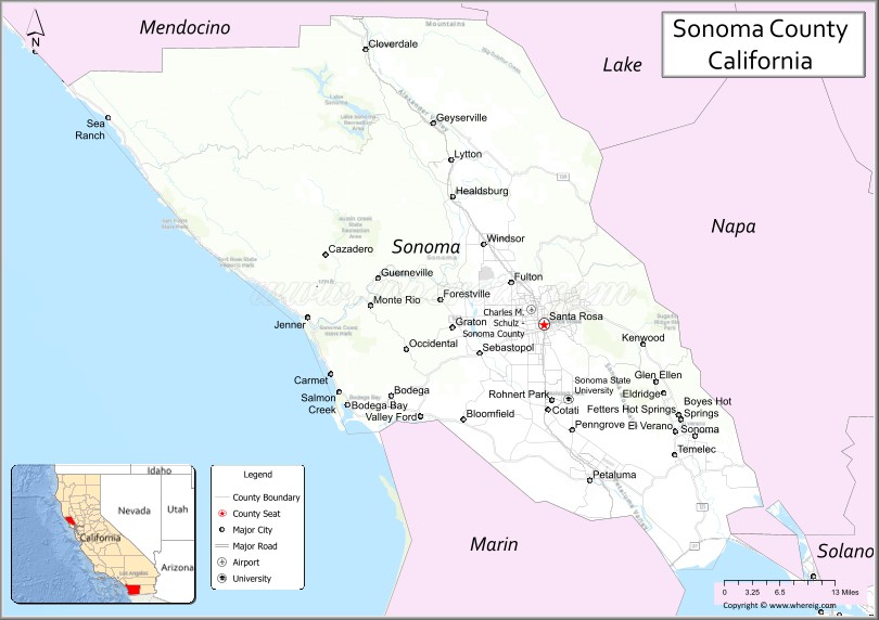
About Sonoma County Map, California: The map showing the county boundary, county seat, major cities, highways, water bodies and neighbouring counties.
Most Viewed Links
About Sonoma County, California
Sonoma County is a county located in the U.S. state of California. It's county seat is Santa Rosa. As per 2020 census, the population of Sonoma County is 485887 people and population density is square miles. According to the United States Census Bureau, the county has a total area of 1,576 sq mi (4,082 km2). Sonoma County was established on 1850.
Sonoma County is known for its beautiful landscape, mild climate, and abundant natural resources. The county is home to several notable cities, including Santa Rosa, Petaluma, and Sonoma. It is also home to several wineries and vineyards, which produce some of the best wines in the world.
The economy of Sonoma County is primarily based on agriculture, with wine grapes being the most important crop. The county is also home to several large employers, including Kaiser Permanente, Agilent Technologies, and the County of Sonoma.
Sonoma County has a rich history, with evidence of human habitation dating back thousands of years. The county was home to several Native American tribes, including the Pomo, Miwok, and Wappo. In the 19th century, the area was settled by European-Americans, and the county played an important role in the California Gold Rush. Today, the county has several historic sites, including the Sonoma Plaza, the Jack London State Historic Park, and the Russian River Historical Society Museum.
Facts about Sonoma County, California
| Country | United States |
| State | California |
| Region | Northern California (North Bay / Wine Country) |
| County Seat | Santa Rosa |
| Named After | Sonoma Valley (name of Native American origin) |
| Established | 1850 |
| Organized | 1850 |
| Coordinates | 38.5780° N, 122.9888° W |
| Total Area | 1,768 sq mi |
| Land Area | 1,576 sq mi |
| Water Area | 192 sq mi |
| Population (2020) | 488,863 |
| Population Rank | Mid-sized county in California |
| Major Cities | Santa Rosa, Petaluma, Rohnert Park, Healdsburg |
| Main Industries | Wine Production, Tourism, Agriculture, Healthcare |
| Major Airport | Charles M. Schulz–Sonoma County Airport |
| Time Zone | Pacific Time (UTC−08:00) |
| Known For | Wine country, Russian River, Coastal scenery, Vineyards |
| Website | https://sonomacounty.ca.gov |
Ctities and Towns in Sonoma County
| City Name | Type | Population (2020) | Pop. Density | Area | Incorporated |
|---|---|---|---|---|---|
| Cloverdale | City | 8,996 | 2,865.0/sq mi (1,106.2/km2) | 3.14 sq mi (8.1 km2) | February 28, 1872 |
| Cotati | City | 7,584 | 4,055.6/sq mi (1,565.9/km2) | 1.87 sq mi (4.8 km2) | July 16, 1963 |
| Healdsburg | City | 11,340 | 2,565.6/sq mi (990.6/km2) | 4.42 sq mi (11.4 km2) | February 20, 1867 |
| Petaluma | City | 59,776 | 4,145.4/sq mi (1,600.5/km2) | 14.42 sq mi (37.3 km2) | April 12, 1858 |
| Rohnert Park | City | 44,390 | 6,089.2/sq mi (2,351.0/km2) | 7.29 sq mi (18.9 km2) | August 28, 1962 |
| Santa Rosa | City | 178,127 | 4,188.3/sq mi (1,617.1/km2) | 42.53 sq mi (110.2 km2) | March 26, 1868 |
| Sebastopol | City | 7,521 | 4,000.5/sq mi (1,544.6/km2) | 1.88 sq mi (4.9 km2) | June 13, 1902 |
| Sonoma | City | 10,739 | 3,919.3/sq mi (1,513.3/km2) | 2.74 sq mi (7.1 km2) | September 3, 1883 |
| Windsor | Town | 26,344 | 3,540.9/sq mi (1,367.1/km2) | 7.44 sq mi (19.3 km2) | July 1, 1992 |
Places to Visit in Sonoma County
Top places to visit in Sonoma includes Sonoma Plaza, Sonoma TrainTown, Sonoma Coast State Park, Safari West, Jack London State Historic, Gundlach Bundschu Winery, Spring Lake Park, Sonoma Garden Park, Sugarloaf Ridge State Park.
Highways in Sonoma County
U.S. Route 101, State Route 1, State Route 12, State Route 37, State Route 116, State Route 121, State Route 128.
Nearest Airports
Nearest airport of Sonoma is Charles M. Schulz-Sonoma County Airport (STS).
- Alameda County Map
- Alpine County Map
- Amador County Map
- Butte County Map
- Calaveras County Map
- Colusa County Map
- Contra Costa County Map
- Del Norte County Map
- El Dorado County Map
- Fresno County Map
- Glenn County Map
- Humboldt County Map
- Imperial County Map
- Inyo County Map
- Kern County Map
- Kings County Map
- Lake County Map
- Lassen County Map
- Los Angeles County Map
- Madera County Map
- Marin County Map
- Mariposa County Map
- Mendocino County Map
- Merced County Map
- Modoc County Map
- Mono County Map
- Monterey County Map
- Napa County Map
- Nevada County Map
- Orange County Map
- Placer County Map
- Plumas County Map
- Riverside County Map
- Sacramento County Map
- San Benito County Map
- San Bernardino County Map
- San Diego County Map
- San Francisco County Map
- San Joaquin County Map
- San Luis Obispo County Map
- San Mateo County Map
- Santa Barbara County Map
- Santa Clara County Map
- Santa Cruz County Map
- Shasta County Map
- Sierra County Map
- Siskiyou County Map
- Solano County Map
- Sonoma County Map
- Stanislaus County Map
- Sutter County Map
- Tehama County Map
- Trinity County Map
- Tulare County Map
- Tuolumne County Map
- Ventura County Map
- Yolo County Map
- Yuba County Map
- Alabama Counties
- Alaska boroughs
- Arizona Counties
- Arkansas Counties
- California County Map
- Colorado Counties
- Connecticut Counties
- Delaware Counties
- Florida County Map
- Georgia County Map
- Hawaii Counties
- Idaho Counties
- Illinois Counties
- Indiana Counties
- Iowa Counties
- Kansas Counties
- Kentucky Counties
- Louisiana Counties
- Maine Counties
- Maryland Counties
- Massachusetts Counties
- Michigan County Map
- Minnesota Counties
- Mississippi Counties
- Missouri Counties
- Montana Counties
- Nebraska Counties
- Nevada Counties
- New York Counties
- New Hampshire Counties
- New Jersey Counties
- New Mexico Counties
- North Carolina Counties
- North Dakota Counties
- Ohio County Map
- Oklahoma Counties
- Oregon Counties
- Pennsylvania Counties
- Rhode Island Counties
- South Carolina Counties
- South Dakota Counties
- Map of Tennessee
- Texas County Map
- Utah Counties
- Vermont Counties
- Virginia Counties
- Washington Counties
- West Virginia Counties
- Wisconsin Counties
- Wyoming Counties