Written and fact-checked by Whereig.com Web Team | Last Updated: December 16, 2025, 14:30 ET
Map of Alameda County - Alameda County is a county located in the U.S. state of California. It's county seat is Oakland. Alameda County Map showing cities, highways, important places and water bodies.
Alameda County Map, California
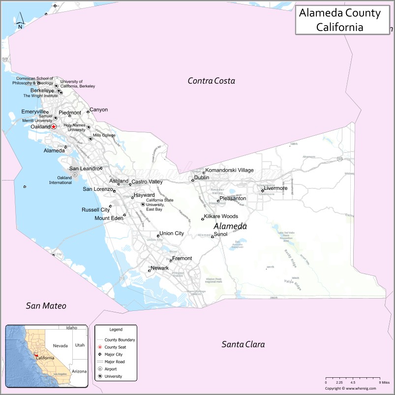
About Alameda County Map, California: The map showing the county boundary, county seat, major cities, highways, water bodies and neighbouring counties.
Most Viewed Links
About Alameda County, California
Alameda County is a county located in the state of California, United States. It is located in the eastern part of the San Francisco Bay Area, and its county seat is Oakland. The county is named after the Spanish word for "poplar grove."
According to the United States Census Bureau, as of the 2020 census, the population of Alameda County was approximately 1.7 million people, making it the seventh-most populous county in California. The county covers an area of approximately 738 square miles (1,910 km²). Alameda County was established on 1853.
Alameda County is home to a number of major cities and towns, including Oakland, Berkeley, Fremont, Hayward, and San Leandro. It is known for its diverse population, cultural attractions, and thriving economy. The county is also home to several universities and colleges, including the University of California, Berkeley and California State University, East Bay.
Facts about Alameda County, California
| Country | United States |
| State | California |
| Region | San Francisco Bay Area (East Bay) |
| County Seat | Oakland |
| Named After | Spanish word “Alameda” meaning “tree-lined avenue” |
| Established | 1853 |
| Organized | 1853 |
| Coordinates | 37.6463° N, 121.8924° W |
| Total Area | 821 sq mi |
| Land Area | 739 sq mi |
| Water Area | 82 sq mi |
| Population (2020) | 1,682,353 |
| Population Rank | One of the most populous counties in California |
| Major City | Oakland |
| Main Industries | Technology, Healthcare, Education, Logistics, Biotechnology |
| Major Airport | Oakland International Airport |
| Time Zone | Pacific Time (UTC−08:00) |
| Known For | East Bay cities, UC Berkeley, Port of Oakland, diverse communities |
| Website | https://www.acgov.org |
Ctities and Towns in Alameda County
| City Name | Type | Population (2020) | Pop. Density | Area | Incorporated |
|---|---|---|---|---|---|
| Alameda | City | 78,280 | 7,490.9/sq mi (2,892.3/km2) | 10.45 sq mi (27.1 km2) | April 19, 1854 |
| Albany | City | 20,271 | 11,324.6/sq mi (4,372.4/km2) | 1.79 sq mi (4.6 km2) | September 22, 1908 |
| Berkeley | City | 124,321 | 11,919.6/sq mi (4,602.2/km2) | 10.43 sq mi (27 km2) | April 4, 1878 |
| Dublin | City | 72,589 | 4,766.2/sq mi (1,840.2/km2) | 15.23 sq mi (39.4 km2) | February 1, 1982 |
| Emeryville | City | 12,905 | 10,161.4/sq mi (3,923.3/km2) | 1.27 sq mi (3.3 km2) | December 8, 1896 |
| Fremont | City | 230,504 | 2,943.5/sq mi (1,136.5/km2) | 78.31 sq mi (202.8 km2) | January 23, 1956 |
| Hayward | City | 162,954 | 3,556.4/sq mi (1,373.1/km2) | 45.82 sq mi (118.7 km2) | March 11, 1876 |
| Livermore | City | 87,955 | 3,325.3/sq mi (1,283.9/km2) | 26.45 sq mi (68.5 km2) | April 1, 1876 |
| Newark | City | 47,529 | 3,414.4/sq mi (1,318.3/km2) | 13.92 sq mi (36.1 km2) | September 22, 1955 |
| Oakland | City | 440,646 | 7,878.5/sq mi (3,041.9/km2) | 55.93 sq mi (144.9 km2) | May 4, 1852 |
| Piedmont | City | 11,270 | 6,629.4/sq mi (2,559.6/km2) | 1.7 sq mi (4.4 km2) | January 31, 1907 |
| Pleasanton | City | 79,871 | 3,308.7/sq mi (1,277.5/km2) | 24.14 sq mi (62.5 km2) | June 18, 1894 |
| San Leandro | City | 91,008 | 6,832.4/sq mi (2,638.0/km2) | 13.32 sq mi (34.5 km2) | March 21, 1872 |
| Union City | City | 70,143 | 3,657.1/sq mi (1,412.0/km2) | 19.18 sq mi (49.7 km2) | January 26, 1959 |
Places to Visit in Alameda County
Top places to visit in Alameda includes USS Hornet - Sea, Air and Space, Robert W. Crown Memorial State, Doug Siden Visitor Center at, Alameda Beach, Washington Park, Marina Village Yacht Harbor, Alameda Point Antiques Faire 1st, Golden Gate Bridge, Alcatraz Island, Trabocco Kitchen and Cocktails, Forbidden Island, Coit Tower, Jean Sweeney Open Space Park, Alameda Dog Park, Battery Spencer, Estuary Park, Alameda.
Highways in Alameda County
California State Route 61, Interstate 880.
Nearest Airports
Nearest airport of Alameda is Nearest Airports.
- Alameda County Map
- Alpine County Map
- Amador County Map
- Butte County Map
- Calaveras County Map
- Colusa County Map
- Contra Costa County Map
- Del Norte County Map
- El Dorado County Map
- Fresno County Map
- Glenn County Map
- Humboldt County Map
- Imperial County Map
- Inyo County Map
- Kern County Map
- Kings County Map
- Lake County Map
- Lassen County Map
- Los Angeles County Map
- Madera County Map
- Marin County Map
- Mariposa County Map
- Mendocino County Map
- Merced County Map
- Modoc County Map
- Mono County Map
- Monterey County Map
- Napa County Map
- Nevada County Map
- Orange County Map
- Placer County Map
- Plumas County Map
- Riverside County Map
- Sacramento County Map
- San Benito County Map
- San Bernardino County Map
- San Diego County Map
- San Francisco County Map
- San Joaquin County Map
- San Luis Obispo County Map
- San Mateo County Map
- Santa Barbara County Map
- Santa Clara County Map
- Santa Cruz County Map
- Shasta County Map
- Sierra County Map
- Siskiyou County Map
- Solano County Map
- Sonoma County Map
- Stanislaus County Map
- Sutter County Map
- Tehama County Map
- Trinity County Map
- Tulare County Map
- Tuolumne County Map
- Ventura County Map
- Yolo County Map
- Yuba County Map
- Alabama Counties
- Alaska boroughs
- Arizona Counties
- Arkansas Counties
- California County Map
- Colorado Counties
- Connecticut Counties
- Delaware Counties
- Florida County Map
- Georgia County Map
- Hawaii Counties
- Idaho Counties
- Illinois Counties
- Indiana Counties
- Iowa Counties
- Kansas Counties
- Kentucky Counties
- Louisiana Counties
- Maine Counties
- Maryland Counties
- Massachusetts Counties
- Michigan County Map
- Minnesota Counties
- Mississippi Counties
- Missouri Counties
- Montana Counties
- Nebraska Counties
- Nevada Counties
- New York Counties
- New Hampshire Counties
- New Jersey Counties
- New Mexico Counties
- North Carolina Counties
- North Dakota Counties
- Ohio County Map
- Oklahoma Counties
- Oregon Counties
- Pennsylvania Counties
- Rhode Island Counties
- South Carolina Counties
- South Dakota Counties
- Map of Tennessee
- Texas County Map
- Utah Counties
- Vermont Counties
- Virginia Counties
- Washington Counties
- West Virginia Counties
- Wisconsin Counties
- Wyoming Counties