Written and fact-checked by Whereig.com Web Team | Last Updated: December 16, 2025, 14:30 ET
Map of Santa Barbara County - Santa Barbara County is a county located in the U.S. state of California. Santa Barbara County Map showing cities, highways, important places and water bodies. Get Where is Santa Barbara County located in the map, major cities in Santa Barbara county, population, areas, and places of interest.
Santa Barbara County Map, California
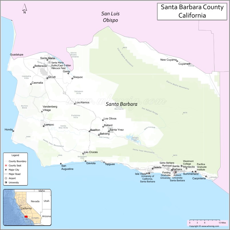
About Santa Barbara County Map, California: The map showing the county boundary, county seat, major cities, highways, water bodies and neighbouring counties.
Most Viewed Links
About Santa Barbara County, California
Santa Barbara County is a county located in central California, It's county seat is Santa Barbara. As per 2020 census, the population of Santa Barbara County is 446475 people and population density is square miles. According to the United States Census Bureau, the county has a total area of 2,738 sq mi (7,091 km2). Santa Barbara County was established on 1850.
Santa Barbara County is known for its scenic coastline, vineyards, and Spanish-style architecture. Some of the popular destinations in the county include the Santa Ynez Valley wine region, the Channel Islands National Park, and the Santa Barbara Mission.
The county is also home to several prestigious universities and colleges, including the University of California, Santa Barbara, and Westmont College. Additionally, Santa Barbara County has a thriving arts and culture scene, with numerous galleries, museums, and performing arts venues.
Economically, Santa Barbara County is driven by a mix of industries, including tourism, agriculture, healthcare, and technology. The county is also home to several military installations, including Vandenberg Air Force Base and the Naval Base Ventura County.
Santa Barbara County has a high quality of life, with a strong emphasis on environmental protection and sustainability. The county has implemented several initiatives aimed at reducing greenhouse gas emissions, promoting clean energy, and preserving natural habitats. The county's natural beauty, diverse economy, and cultural offerings make it a desirable place to live and visit.
Facts about Santa Barbara County, California
| Country | United States |
| State | California |
| Region | Central Coast California |
| County Seat | Santa Barbara |
| Named After | Mission Santa Barbara |
| Established | 1850 |
| Organized | 1850 |
| Coordinates | 34.5383° N, 120.0256° W |
| Total Area | 3,789 sq mi |
| Land Area | 2,735 sq mi |
| Water Area | 1,054 sq mi |
| Population (2020) | 446,499 |
| Population Rank | Mid-sized county in California |
| Major Cities | Santa Barbara, Santa Maria, Goleta, Lompoc |
| Main Industries | Agriculture, Tourism, Education, Technology |
| Major Airport | Santa Barbara Municipal Airport |
| Time Zone | Pacific Time (UTC−08:00) |
| Known For | Mediterranean-style architecture, Vineyards, Coastal scenery, Channel Islands (nearby) |
| Website | https://www.countyofsb.org |
Ctities and Towns in Santa Barbara County
| City Name | Type | Population (2020) | Pop. Density | Area | Incorporated |
|---|---|---|---|---|---|
| Buellton | City | 5,161 | 3,266.5/sq mi (1,261.2/km2) | 1.58 sq mi (4.1 km2) | February 1, 1992 |
| Carpinteria | City | 13,264 | 5,121.2/sq mi (1,977.3/km2) | 2.59 sq mi (6.7 km2) | September 28, 1965 |
| Goleta | City | 32,690 | 4,164.3/sq mi (1,607.9/km2) | 7.85 sq mi (20.3 km2) | February 1, 2002 |
| Guadalupe | City | 8,057 | 6,150.4/sq mi (2,374.7/km2) | 1.31 sq mi (3.4 km2) | August 3, 1946 |
| Lompoc | City | 44,444 | 3,824.8/sq mi (1,476.8/km2) | 11.62 sq mi (30.1 km2) | August 13, 1888 |
| Santa Barbara | City | 88,665 | 4,544.6/sq mi (1,754.7/km2) | 19.51 sq mi (50.5 km2) | April 9, 1850 |
| Santa Maria | City | 109,707 | 4,809.6/sq mi (1,857.0/km2) | 22.81 sq mi (59.1 km2) | September 12, 1905 |
| Solvang | City | 6,126 | 2,521.0/sq mi (973.4/km2) | 2.43 sq mi (6.3 km2) | May 1, 1985 |
Places to Visit in Santa Barbara County
Top places to visit in Santa Barbara includes Old Mission Santa Barbara, Santa Barbara Zoo, Stearns Wharf, Arroyo Burro Beach County, Santa Barbara Museum , Superior Court Of California, Shoreline Park.
Highways in Santa Barbara County
U.S. Route 101, State Route 1, State Route 33, State Route 135, State Route 144, State Route 154, State Route 166, State Route 192, State Route 217, State Route 246.
Nearest Airports
Nearest airport of Santa Barbara is Santa Barbara Airport.
- Alameda County Map
- Alpine County Map
- Amador County Map
- Butte County Map
- Calaveras County Map
- Colusa County Map
- Contra Costa County Map
- Del Norte County Map
- El Dorado County Map
- Fresno County Map
- Glenn County Map
- Humboldt County Map
- Imperial County Map
- Inyo County Map
- Kern County Map
- Kings County Map
- Lake County Map
- Lassen County Map
- Los Angeles County Map
- Madera County Map
- Marin County Map
- Mariposa County Map
- Mendocino County Map
- Merced County Map
- Modoc County Map
- Mono County Map
- Monterey County Map
- Napa County Map
- Nevada County Map
- Orange County Map
- Placer County Map
- Plumas County Map
- Riverside County Map
- Sacramento County Map
- San Benito County Map
- San Bernardino County Map
- San Diego County Map
- San Francisco County Map
- San Joaquin County Map
- San Luis Obispo County Map
- San Mateo County Map
- Santa Barbara County Map
- Santa Clara County Map
- Santa Cruz County Map
- Shasta County Map
- Sierra County Map
- Siskiyou County Map
- Solano County Map
- Sonoma County Map
- Stanislaus County Map
- Sutter County Map
- Tehama County Map
- Trinity County Map
- Tulare County Map
- Tuolumne County Map
- Ventura County Map
- Yolo County Map
- Yuba County Map
- Alabama Counties
- Alaska boroughs
- Arizona Counties
- Arkansas Counties
- California County Map
- Colorado Counties
- Connecticut Counties
- Delaware Counties
- Florida County Map
- Georgia County Map
- Hawaii Counties
- Idaho Counties
- Illinois Counties
- Indiana Counties
- Iowa Counties
- Kansas Counties
- Kentucky Counties
- Louisiana Counties
- Maine Counties
- Maryland Counties
- Massachusetts Counties
- Michigan County Map
- Minnesota Counties
- Mississippi Counties
- Missouri Counties
- Montana Counties
- Nebraska Counties
- Nevada Counties
- New York Counties
- New Hampshire Counties
- New Jersey Counties
- New Mexico Counties
- North Carolina Counties
- North Dakota Counties
- Ohio County Map
- Oklahoma Counties
- Oregon Counties
- Pennsylvania Counties
- Rhode Island Counties
- South Carolina Counties
- South Dakota Counties
- Map of Tennessee
- Texas County Map
- Utah Counties
- Vermont Counties
- Virginia Counties
- Washington Counties
- West Virginia Counties
- Wisconsin Counties
- Wyoming Counties