Written and fact-checked by Whereig.com Web Team | Last Updated: December 16, 2025, 14:30 ET
Map of Amador County - Amador County is a county located in the U.S. state of California. Amador County Map showing cities, highways, important places and water bodies. Get Where is Amador County located in the map, major cities in Amador county, population, areas, and places of interest.
Amador County Map, California
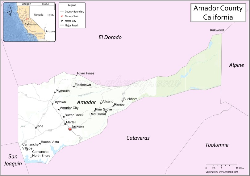
About Amador County Map, California: The map showing the county boundary, county seat, major cities, highways, water bodies and neighbouring counties.
Most Viewed Links
About Amador County, California
Amador County is a county in the central part of the U.S. state of California. It is located in the Sierra Nevada foothills, between Sacramento and Lake Tahoe.
As per 2020 census, the population of Amador County is 41259 people and population density is square miles. According to the United States Census Bureau, the county has a total area of 606 sq mi (1,570 km2). Amador County was established on 1854.
The county seat is Jackson, and other communities within the county include Sutter Creek, Plymouth, and Amador City. The county is known for its vineyards and wineries, and it is part of the larger California wine region. The county is also home to several outdoor recreational areas, including the Mokelumne River and the Eldorado National Forest.
Amador County is named after Jose Maria Amador, a wealthy ranchero who was one of the first European settlers in the region. The county is bordered by El Dorado County to the west, Calaveras County to the north, Alpine County to the northeast, and San Joaquin County to the south.
Facts about Amador County, California
| Country | United States |
| State | California |
| Region | Sierra Nevada foothills |
| County Seat | Jackson |
| Named After | José María Amador |
| Established | 1854 |
| Organized | 1854 |
| Coordinates | 38.4458° N, 120.6539° W |
| Total Area | 606 sq mi |
| Land Area | 593 sq mi |
| Water Area | 13 sq mi |
| Population (2020) | 40,474 |
| Population Rank | Small-to-mid-sized county in California |
| Major Cities | Jackson, Sutter Creek, Plymouth |
| Main Industries | Tourism, Wine Production, Agriculture, Government Services |
| Major Airport | None (nearest commercial airports outside the county) |
| Time Zone | Pacific Time (UTC−08:00) |
| Known For | California Gold Rush history, Shenandoah Valley wine region, Historic towns |
| Website | https://www.amadorgov.org |
Ctities and Towns in Amador County
| City Name | Type | Population (2020) | Pop. Density | Area | Incorporated |
|---|---|---|---|---|---|
| Amador City | City | 200 | 645.2/sq mi (249.1/km2) | 0.31 sq mi (0.8 km2) | June 2, 1915 |
| Ione | City | 5,141 | 1,122.5/sq mi (433.4/km2) | 4.58 sq mi (11.9 km2) | March 23, 1953 |
| Jackson | City | 5,019 | 1,402.0/sq mi (541.3/km2) | 3.58 sq mi (9.3 km2) | December 5, 1905 |
| Plymouth | City | 1,078 | 406.8/sq mi (157.1/km2) | 2.65 sq mi (6.9 km2) | February 8, 1917 |
| Sutter Creek | City | 2,646 | 980.0/sq mi (378.4/km2) | 2.7 sq mi (7 km2) | February 11, 1913 |
Places to Visit in Amador County
Top places to visit in Amador includes Black Chasm Cavern National, Kirkwood Mountain Resort, Indian Grinding Rock State, Kennedy Gold Mine Tours, Helwig Vineyards & Winery, Karmere Vineyards , Amador Flower Farm, Villa Toscano Winery, Deaver Vineyards, Kennedy Tailing Wheels Park.
Nearest Airports
Nearest airport of Amador is Amador County Airport.
- Alameda County Map
- Alpine County Map
- Amador County Map
- Butte County Map
- Calaveras County Map
- Colusa County Map
- Contra Costa County Map
- Del Norte County Map
- El Dorado County Map
- Fresno County Map
- Glenn County Map
- Humboldt County Map
- Imperial County Map
- Inyo County Map
- Kern County Map
- Kings County Map
- Lake County Map
- Lassen County Map
- Los Angeles County Map
- Madera County Map
- Marin County Map
- Mariposa County Map
- Mendocino County Map
- Merced County Map
- Modoc County Map
- Mono County Map
- Monterey County Map
- Napa County Map
- Nevada County Map
- Orange County Map
- Placer County Map
- Plumas County Map
- Riverside County Map
- Sacramento County Map
- San Benito County Map
- San Bernardino County Map
- San Diego County Map
- San Francisco County Map
- San Joaquin County Map
- San Luis Obispo County Map
- San Mateo County Map
- Santa Barbara County Map
- Santa Clara County Map
- Santa Cruz County Map
- Shasta County Map
- Sierra County Map
- Siskiyou County Map
- Solano County Map
- Sonoma County Map
- Stanislaus County Map
- Sutter County Map
- Tehama County Map
- Trinity County Map
- Tulare County Map
- Tuolumne County Map
- Ventura County Map
- Yolo County Map
- Yuba County Map
- Alabama Counties
- Alaska boroughs
- Arizona Counties
- Arkansas Counties
- California County Map
- Colorado Counties
- Connecticut Counties
- Delaware Counties
- Florida County Map
- Georgia County Map
- Hawaii Counties
- Idaho Counties
- Illinois Counties
- Indiana Counties
- Iowa Counties
- Kansas Counties
- Kentucky Counties
- Louisiana Counties
- Maine Counties
- Maryland Counties
- Massachusetts Counties
- Michigan County Map
- Minnesota Counties
- Mississippi Counties
- Missouri Counties
- Montana Counties
- Nebraska Counties
- Nevada Counties
- New York Counties
- New Hampshire Counties
- New Jersey Counties
- New Mexico Counties
- North Carolina Counties
- North Dakota Counties
- Ohio County Map
- Oklahoma Counties
- Oregon Counties
- Pennsylvania Counties
- Rhode Island Counties
- South Carolina Counties
- South Dakota Counties
- Map of Tennessee
- Texas County Map
- Utah Counties
- Vermont Counties
- Virginia Counties
- Washington Counties
- West Virginia Counties
- Wisconsin Counties
- Wyoming Counties