Written and fact-checked by Whereig.com Web Team | Last Updated: December 16, 2025, 14:30 ET
Map of Contra Costa County - Contra Costa County is a county located in the U.S. state of California. Contra Costa County Map showing cities, highways, important places and water bodies. Get Where is Contra Costa County located in the map, major cities in Contra Costa county, population, areas, and places of interest.
Contra Costa County Map, California
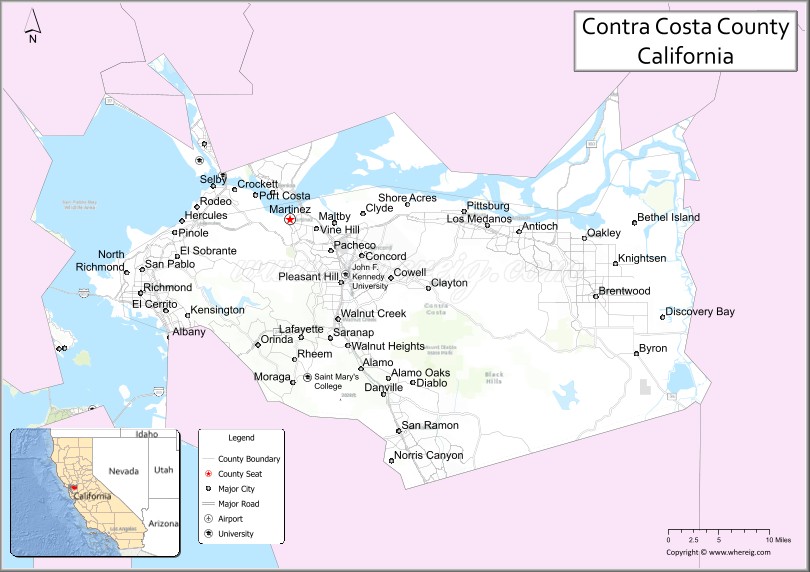
About Contra Costa County Map, California: The map showing the county boundary, county seat, major cities, highways, water bodies and neighbouring counties.
Most Viewed Links
About Contra Costa County, California
I believe you may be referring to Contra Costa County, which is a county located in the state of California in the United States. Its county seat is Martinez, and it is part of the San Francisco Bay Area.
Contra Costa County has a population of approximately 1.2 million people and covers an area of about 729 square miles. It's county seat is Martinez. As per 2020 census, the population of Contra Costa County is 1161413 people and population density is square miles. According to the United States Census Bureau, the county has a total area of 720 sq mi (1,865 km2). Contra Costa County was established on 1850.
If you have any specific questions about Contra Costa County, feel free to ask and I'll do my best to assist you!
Facts about Contra Costa County, California
| Country | United States |
| State | California |
| Region | San Francisco Bay Area (East Bay) |
| County Seat | Martinez |
| Named After | Spanish term “Contra Costa,” meaning “opposite coast” |
| Established | 1850 |
| Organized | 1850 |
| Coordinates | 37.9195° N, 121.9510° W |
| Total Area | 804 sq mi |
| Land Area | 716 sq mi |
| Water Area | 88 sq mi |
| Population (2020) | 1,165,927 |
| Population Rank | One of the largest counties in California |
| Major Cities | Concord, Richmond, Antioch, Walnut Creek |
| Main Industries | Healthcare, Education, Energy, Manufacturing, Professional Services |
| Major Airport | Buchanan Field Airport |
| Time Zone | Pacific Time (UTC−08:00) |
| Known For | East Bay communities, Mount Diablo, San Francisco Bay shoreline, Regional parks |
| Website | https://www.contracosta.ca.gov |
Ctities and Towns in Contra Costa County
| City Name | Type | Population (2020) | Pop. Density | Area | Incorporated |
|---|---|---|---|---|---|
| Antioch | City | 115,291 | 3,952.4/sq mi (1,526.0/km2) | 29.17 sq mi (75.5 km2) | February 6, 1872 |
| Brentwood | City | 64,292 | 4,323.6/sq mi (1,669.4/km2) | 14.87 sq mi (38.5 km2) | January 21, 1948 |
| Clayton | City | 11,070 | 2,882.8/sq mi (1,113.1/km2) | 3.84 sq mi (9.9 km2) | March 18, 1964 |
| Concord | City | 125,410 | 4,105.1/sq mi (1,585.0/km2) | 30.55 sq mi (79.1 km2) | February 9, 1905 |
| Danville | Town | 43,582 | 2,410.5/sq mi (930.7/km2) | 18.08 sq mi (46.8 km2) | July 1, 1982 |
| El Cerrito | City | 25,962 | 7,074.1/sq mi (2,731.3/km2) | 3.67 sq mi (9.5 km2) | August 23, 1917 |
| Hercules | City | 26,016 | 4,058.7/sq mi (1,567.1/km2) | 6.41 sq mi (16.6 km2) | December 15, 1900 |
| Lafayette | City | 25,391 | 1,690.5/sq mi (652.7/km2) | 15.02 sq mi (38.9 km2) | July 29, 1968 |
| Martinez | City | 37,287 | 2,952.3/sq mi (1,139.9/km2) | 12.63 sq mi (32.7 km2) | April 1, 1876 |
| Moraga | Town | 16,870 | 1,783.3/sq mi (688.5/km2) | 9.46 sq mi (24.5 km2) | November 13, 1974 |
| Oakley | City | 43,357 | 2,732.0/sq mi (1,054.8/km2) | 15.87 sq mi (41.1 km2) | July 1, 1999 |
| Orinda | City | 19,514 | 1,518.6/sq mi (586.3/km2) | 12.85 sq mi (33.3 km2) | July 1, 1985 |
| Pinole | City | 19,022 | 3,729.8/sq mi (1,440.1/km2) | 5.1 sq mi (13.2 km2) | June 25, 1903 |
| Pittsburg | City | 76,416 | 4,322.2/sq mi (1,668.8/km2) | 17.68 sq mi (45.8 km2) | June 25, 1903 |
| Pleasant Hill | City | 34,613 | 4,888.8/sq mi (1,887.6/km2) | 7.08 sq mi (18.3 km2) | November 14, 1961 |
| Richmond | City | 116,448 | 3,875.1/sq mi (1,496.2/km2) | 30.05 sq mi (77.8 km2) | August 7, 1905 |
| San Pablo | City | 32,127 | 12,262.2/sq mi (4,734.5/km2) | 2.62 sq mi (6.8 km2) | April 27, 1948 |
| San Ramon | City | 84,605 | 4,526.8/sq mi (1,747.8/km2) | 18.69 sq mi (48.4 km2) | July 1, 1983 |
| Walnut Creek | City | 70,127 | 3,548.9/sq mi (1,370.3/km2) | 19.76 sq mi (51.2 km2) | October 21, 1914 |
Places to Visit in Contra Costa County
Top places to visit in Contra Costa includes Golden Gate Bridge, Alcatraz Island, The Ruth Bancroft Garden, Black Diamond Mines Regional, Palace of Fine Arts, Rosie the Riveter National, .
Highways in Contra Costa County
Interstate 80, Interstate 580, Interstate 680, State Route 4, State Route 24, State Route 160, State Route 242.
Nearest Airports
Nearest airport of Contra Costa is Oakland International Airport (OAK / KOAK).
- Alameda County Map
- Alpine County Map
- Amador County Map
- Butte County Map
- Calaveras County Map
- Colusa County Map
- Contra Costa County Map
- Del Norte County Map
- El Dorado County Map
- Fresno County Map
- Glenn County Map
- Humboldt County Map
- Imperial County Map
- Inyo County Map
- Kern County Map
- Kings County Map
- Lake County Map
- Lassen County Map
- Los Angeles County Map
- Madera County Map
- Marin County Map
- Mariposa County Map
- Mendocino County Map
- Merced County Map
- Modoc County Map
- Mono County Map
- Monterey County Map
- Napa County Map
- Nevada County Map
- Orange County Map
- Placer County Map
- Plumas County Map
- Riverside County Map
- Sacramento County Map
- San Benito County Map
- San Bernardino County Map
- San Diego County Map
- San Francisco County Map
- San Joaquin County Map
- San Luis Obispo County Map
- San Mateo County Map
- Santa Barbara County Map
- Santa Clara County Map
- Santa Cruz County Map
- Shasta County Map
- Sierra County Map
- Siskiyou County Map
- Solano County Map
- Sonoma County Map
- Stanislaus County Map
- Sutter County Map
- Tehama County Map
- Trinity County Map
- Tulare County Map
- Tuolumne County Map
- Ventura County Map
- Yolo County Map
- Yuba County Map
- Alabama Counties
- Alaska boroughs
- Arizona Counties
- Arkansas Counties
- California County Map
- Colorado Counties
- Connecticut Counties
- Delaware Counties
- Florida County Map
- Georgia County Map
- Hawaii Counties
- Idaho Counties
- Illinois Counties
- Indiana Counties
- Iowa Counties
- Kansas Counties
- Kentucky Counties
- Louisiana Counties
- Maine Counties
- Maryland Counties
- Massachusetts Counties
- Michigan County Map
- Minnesota Counties
- Mississippi Counties
- Missouri Counties
- Montana Counties
- Nebraska Counties
- Nevada Counties
- New York Counties
- New Hampshire Counties
- New Jersey Counties
- New Mexico Counties
- North Carolina Counties
- North Dakota Counties
- Ohio County Map
- Oklahoma Counties
- Oregon Counties
- Pennsylvania Counties
- Rhode Island Counties
- South Carolina Counties
- South Dakota Counties
- Map of Tennessee
- Texas County Map
- Utah Counties
- Vermont Counties
- Virginia Counties
- Washington Counties
- West Virginia Counties
- Wisconsin Counties
- Wyoming Counties