Written and fact-checked by Whereig.com Web Team | Last Updated: December 16, 2025, 14:30 ET
Map of San Bernardino County - San Bernardino County is a county located in the U.S. state of California. San Bernardino County Map showing cities, highways, important places and water bodies. Get Where is San Bernardino County located in the map, major cities in San Bernardino county, population, areas, and places of interest.
San Bernardino County Map, California
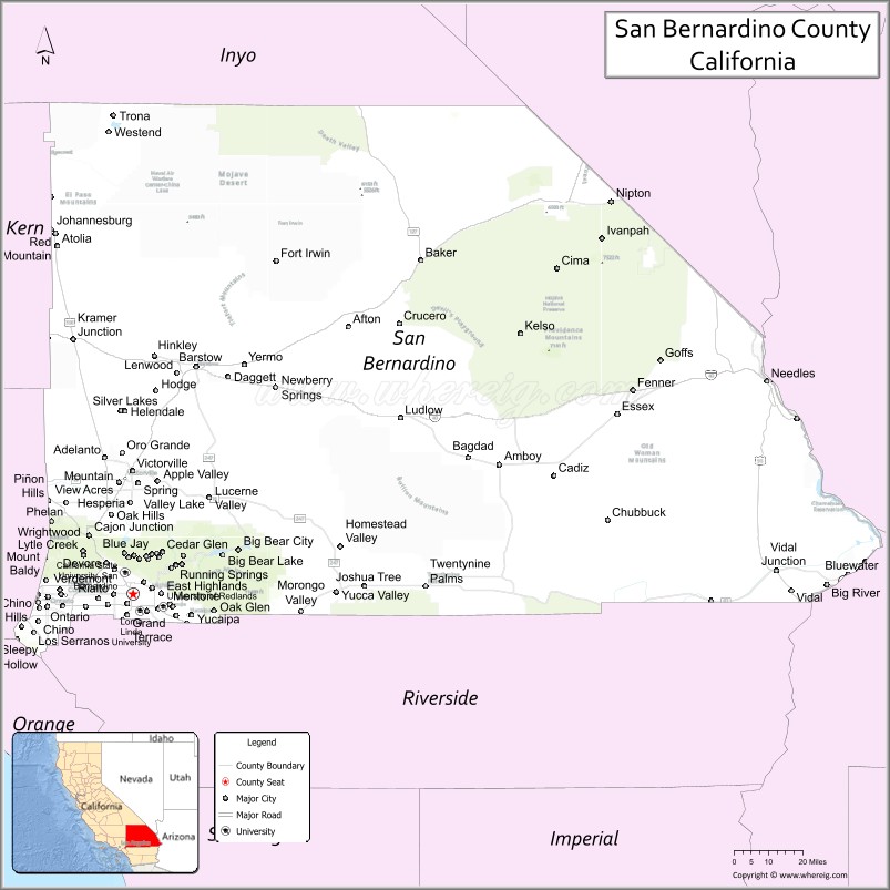
About San Bernardino County Map, California: The map showing the county boundary, county seat, major cities, highways, water bodies and neighbouring counties.
Most Viewed Links
About San Bernardino County, California
San Bernardino County is a county located in Southern California, with its county seat in the city of San Bernardino. The county is the largest in the contiguous United States, covering an area of over 20,000 square miles, and has an estimated population of over 2.1 million people as of 2021.San Bernardino County was established on 1853.
San Bernardino County is known for its diverse geography, including mountains, deserts, and forests. Some of the popular destinations in the county include Big Bear Lake, Joshua Tree National Park, and the Route 66 Museum. The county is also home to several colleges and universities, including California State University, San Bernardino.
Economically, San Bernardino County is driven by a mix of industries, including healthcare, education, logistics, and manufacturing. The county is also a major transportation hub for the state, with several major highways and railways passing through the area.
San Bernardino County is also home to a number of military installations, including the Marine Corps Air Ground Combat Center in Twentynine Palms and the Army's National Training Center at Fort Irwin. The county is also a popular filming location for movies and TV shows due to its diverse landscapes and close proximity to Hollywood.
Facts about San Bernardino County, California
| Country | United States |
| State | California |
| Region | Southern California (Inland Empire, Mojave Desert) |
| County Seat | San Bernardino |
| Named After | San Bernardino de Siena |
| Established | 1853 |
| Organized | 1853 |
| Coordinates | 34.8414° N, 116.1780° W |
| Total Area | 20,105 sq mi |
| Land Area | 20,057 sq mi |
| Water Area | 48 sq mi |
| Population (2020) | 2,181,654 |
| Population Rank | Largest county by area in the contiguous United States |
| Major Cities | San Bernardino, Ontario, Rancho Cucamonga, Victorville |
| Main Industries | Logistics, Manufacturing, Healthcare, Government Services |
| Major Airports | Ontario International Airport, San Bernardino International Airport |
| Time Zone | Pacific Time (UTC−08:00) |
| Known For | Mojave Desert, Joshua Tree National Park (part), Logistics hubs, Vast desert landscapes |
| Website | https://www.sbcounty.gov |
Ctities and Towns in San Bernardino County
| City Name | Type | Population (2020) | Pop. Density | Area | Incorporated |
|---|---|---|---|---|---|
| Adelanto | City | 38,046 | 719.6/sq mi (277.8/km2) | 52.87 sq mi (136.9 km2) | December 22, 1970 |
| Apple Valley | Town | 75,791 | 984.2/sq mi (380.0/km2) | 77.01 sq mi (199.5 km2) | November 28, 1988 |
| Barstow | City | 25,415 | 615.4/sq mi (237.6/km2) | 41.3 sq mi (107 km2) | September 30, 1947 |
| Big Bear Lake | City | 5,046 | 808.7/sq mi (312.2/km2) | 6.24 sq mi (16.2 km2) | November 28, 1980 |
| Chino | City | 91,403 | 3,086.9/sq mi (1,191.9/km2) | 29.61 sq mi (76.7 km2) | February 28, 1910 |
| Chino Hills | City | 78,411 | 1,756.1/sq mi (678.0/km2) | 44.65 sq mi (115.6 km2) | December 1, 1991 |
| Colton | City | 53,909 | 3,466.8/sq mi (1,338.5/km2) | 15.55 sq mi (40.3 km2) | July 11, 1887 |
| Fontana | City | 208,393 | 4,838.5/sq mi (1,868.1/km2) | 43.07 sq mi (111.6 km2) | June 25, 1952 |
| Grand Terrace | City | 13,150 | 3,757.1/sq mi (1,450.6/km2) | 3.5 sq mi (9.1 km2) | November 30, 1978 |
| Hesperia | City | 99,818 | 1,373.4/sq mi (530.3/km2) | 72.68 sq mi (188.2 km2) | July 1, 1988 |
| Highland | City | 56,999 | 3,069.4/sq mi (1,185.1/km2) | 18.57 sq mi (48.1 km2) | November 24, 1987 |
| Loma Linda | City | 24,791 | 3,244.9/sq mi (1,252.9/km2) | 7.64 sq mi (19.8 km2) | September 29, 1970 |
| Montclair | City | 37,865 | 6,847.2/sq mi (2,643.7/km2) | 5.53 sq mi (14.3 km2) | April 25, 1956 |
| Needles | City | 4,931 | 161.2/sq mi (62.3/km2) | 30.58 sq mi (79.2 km2) | October 30, 1913 |
| Ontario | City | 175,265 | 3,507.4/sq mi (1,354.2/km2) | 49.97 sq mi (129.4 km2) | December 10, 1891 |
| Rancho Cucamonga | City | 174,453 | 4,349.4/sq mi (1,679.3/km2) | 40.11 sq mi (103.9 km2) | November 30, 1977 |
| Redlands | City | 73,168 | 2,033.0/sq mi (784.9/km2) | 35.99 sq mi (93.2 km2) | December 3, 1888 |
| Rialto | City | 104,026 | 4,318.2/sq mi (1,667.3/km2) | 24.09 sq mi (62.4 km2) | November 17, 1911 |
| San Bernardino | City | 222,101 | 3,574.8/sq mi (1,380.2/km2) | 62.13 sq mi (160.9 km2) | August 10, 1869 |
| Twentynine Palms | City | 28,065 | 477.7/sq mi (184.4/km2) | 58.75 sq mi (152.2 km2) | November 23, 1987 |
| Upland | City | 79,040 | 5,073.2/sq mi (1,958.8/km2) | 15.58 sq mi (40.4 km2) | May 15, 1906 |
| Victorville | City | 134,810 | 1,828.9/sq mi (706.2/km2) | 73.71 sq mi (190.9 km2) | September 21, 1962 |
| Yucaipa | City | 54,542 | 1,929.3/sq mi (744.9/km2) | 28.27 sq mi (73.2 km2) | November 27, 1989 |
| Yucca Valley | Town | 21,738 | 545.8/sq mi (210.7/km2) | 39.83 sq mi (103.2 km2) | November 27, 1991 |
Places to Visit in San Bernardino County
Top places to visit in San Bernardino includes San Manuel Stadium, San Bernardino National Forest, Blair Park, Big Bear Lake, Rim of the World Scenic Drive, Silverwood Lake State Recreation, Lake Gregory Regional Park, Kimberly Crest House & Gardens, Santa Ana River Trail, Lake Arrowhead, Hulda Crooks Park, San Bernardino County Regional, San Bernardino Valley, Borea Canyon, Arrowhead Springs Hot Lake,Arrowhead Landmark .
Nearest Airports
Nearest airport of San Bernardino is San Bernardino International Apt (SBD) Airport.
- Alameda County Map
- Alpine County Map
- Amador County Map
- Butte County Map
- Calaveras County Map
- Colusa County Map
- Contra Costa County Map
- Del Norte County Map
- El Dorado County Map
- Fresno County Map
- Glenn County Map
- Humboldt County Map
- Imperial County Map
- Inyo County Map
- Kern County Map
- Kings County Map
- Lake County Map
- Lassen County Map
- Los Angeles County Map
- Madera County Map
- Marin County Map
- Mariposa County Map
- Mendocino County Map
- Merced County Map
- Modoc County Map
- Mono County Map
- Monterey County Map
- Napa County Map
- Nevada County Map
- Orange County Map
- Placer County Map
- Plumas County Map
- Riverside County Map
- Sacramento County Map
- San Benito County Map
- San Bernardino County Map
- San Diego County Map
- San Francisco County Map
- San Joaquin County Map
- San Luis Obispo County Map
- San Mateo County Map
- Santa Barbara County Map
- Santa Clara County Map
- Santa Cruz County Map
- Shasta County Map
- Sierra County Map
- Siskiyou County Map
- Solano County Map
- Sonoma County Map
- Stanislaus County Map
- Sutter County Map
- Tehama County Map
- Trinity County Map
- Tulare County Map
- Tuolumne County Map
- Ventura County Map
- Yolo County Map
- Yuba County Map
- Alabama Counties
- Alaska boroughs
- Arizona Counties
- Arkansas Counties
- California County Map
- Colorado Counties
- Connecticut Counties
- Delaware Counties
- Florida County Map
- Georgia County Map
- Hawaii Counties
- Idaho Counties
- Illinois Counties
- Indiana Counties
- Iowa Counties
- Kansas Counties
- Kentucky Counties
- Louisiana Counties
- Maine Counties
- Maryland Counties
- Massachusetts Counties
- Michigan County Map
- Minnesota Counties
- Mississippi Counties
- Missouri Counties
- Montana Counties
- Nebraska Counties
- Nevada Counties
- New York Counties
- New Hampshire Counties
- New Jersey Counties
- New Mexico Counties
- North Carolina Counties
- North Dakota Counties
- Ohio County Map
- Oklahoma Counties
- Oregon Counties
- Pennsylvania Counties
- Rhode Island Counties
- South Carolina Counties
- South Dakota Counties
- Map of Tennessee
- Texas County Map
- Utah Counties
- Vermont Counties
- Virginia Counties
- Washington Counties
- West Virginia Counties
- Wisconsin Counties
- Wyoming Counties