Written and fact-checked by Whereig.com Web Team | Last Updated: December 16, 2025, 14:30 ET
Map of Butte County - Butte County is a county located in the U.S. state of California. Butte County Map showing cities, highways, important places and water bodies. Get Where is Butte County located in the map, major cities in Butte county, population, areas, and places of interest.
Butte County Map, California
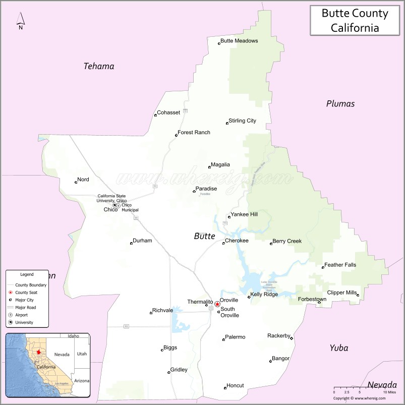
About Butte County Map, California: The map showing the county boundary, county seat, major cities, highways, water bodies and neighbouring counties.
Most Viewed Links
About Butte County, California
Butte County is a county in the northern part of the U.S. state of California. It is located in the Sacramento Valley and Sierra Nevada regions. The county was created in 1850, just a few months after California became a state. Butte county seat is Oroville. As per 2020 census, the population of Butte County is 208309 people and population density is square miles. According to the United States Census Bureau, the county has a total area of 1,640 sq mi (4,248 km2).
The county seat is Oroville, and other communities within the county include Chico, Paradise, and Gridley. The county is home to several outdoor recreational areas, including Bidwell Park in Chico, Lake Oroville, and the Feather River.
Butte County is also known for its agricultural industry, particularly for the production of almonds and rice. The county is home to California State University, Chico, which is the second-oldest campus in the California State University system.
Butte County gained national attention in 2018 due to the devastating Camp Fire, which destroyed much of the town of Paradise and was one of the deadliest and most destructive wildfires in California history. The county is bordered by Sutter County to the south, Yuba County to the southwest, Plumas County to the north, and Tehama County to the east.
Facts about Butte County, California
| Country | United States |
| State | California |
| Region | Northern California (Sacramento Valley & Sierra Nevada foothills) |
| County Seat | Oroville |
| Named After | Buttes (isolated hills) in the area |
| Established | 1850 |
| Organized | 1850 |
| Coordinates | 39.6663° N, 121.6007° W |
| Total Area | 1,640 sq mi |
| Land Area | 1,636 sq mi |
| Water Area | 4 sq mi |
| Population (2020) | 211,632 |
| Population Rank | Mid-sized county in California |
| Major Cities | Chico, Oroville, Paradise |
| Main Industries | Education, Agriculture, Healthcare, Government Services |
| Major Airport | Chico Municipal Airport |
| Time Zone | Pacific Time (UTC−08:00) |
| Known For | California State University, Chico, Lake Oroville, Feather River, Gold Rush history |
| Website | https://www.buttecounty.net |
Ctities and Towns in Butte County
| City Name | Type | Population (2020) | Pop. Density | Area | Incorporated |
|---|---|---|---|---|---|
| Biggs | City | 1,964 | 2,182.2/sq mi (842.6/km2) | 0.9 sq mi (2.3 km2) | June 26, 1903 |
| Chico | City | 101,475 | 2,972.3/sq mi (1,147.6/km2) | 34.14 sq mi (88.4 km2) | January 8, 1872 |
| Gridley | City | 7,421 | 3,550.7/sq mi (1,370.9/km2) | 2.09 sq mi (5.4 km2) | November 23, 1905 |
| Oroville | City | 20,042 | 1,449.2/sq mi (559.5/km2) | 13.83 sq mi (35.8 km2) | January 3, 1906 |
| Paradise | Town | 4,764 | 260.0/sq mi (100.4/km2) | 18.32 sq mi (47.4 km2) | November 27, 1979 |
Places to Visit in Butte County
Top places to visit in Butte includes Lake Oroville State Rec Area, Upper Bidwell Park, Butte Creek Canyon, Bidwell Bar Bridge, Feather River Fish Hatchery, Mother Orange Tree of Butte.
Nearest Airports
Nearest airport of Butte is Chico Municipal Airport (CIC / KCIC).
- Alameda County Map
- Alpine County Map
- Amador County Map
- Butte County Map
- Calaveras County Map
- Colusa County Map
- Contra Costa County Map
- Del Norte County Map
- El Dorado County Map
- Fresno County Map
- Glenn County Map
- Humboldt County Map
- Imperial County Map
- Inyo County Map
- Kern County Map
- Kings County Map
- Lake County Map
- Lassen County Map
- Los Angeles County Map
- Madera County Map
- Marin County Map
- Mariposa County Map
- Mendocino County Map
- Merced County Map
- Modoc County Map
- Mono County Map
- Monterey County Map
- Napa County Map
- Nevada County Map
- Orange County Map
- Placer County Map
- Plumas County Map
- Riverside County Map
- Sacramento County Map
- San Benito County Map
- San Bernardino County Map
- San Diego County Map
- San Francisco County Map
- San Joaquin County Map
- San Luis Obispo County Map
- San Mateo County Map
- Santa Barbara County Map
- Santa Clara County Map
- Santa Cruz County Map
- Shasta County Map
- Sierra County Map
- Siskiyou County Map
- Solano County Map
- Sonoma County Map
- Stanislaus County Map
- Sutter County Map
- Tehama County Map
- Trinity County Map
- Tulare County Map
- Tuolumne County Map
- Ventura County Map
- Yolo County Map
- Yuba County Map
- Alabama Counties
- Alaska boroughs
- Arizona Counties
- Arkansas Counties
- California County Map
- Colorado Counties
- Connecticut Counties
- Delaware Counties
- Florida County Map
- Georgia County Map
- Hawaii Counties
- Idaho Counties
- Illinois Counties
- Indiana Counties
- Iowa Counties
- Kansas Counties
- Kentucky Counties
- Louisiana Counties
- Maine Counties
- Maryland Counties
- Massachusetts Counties
- Michigan County Map
- Minnesota Counties
- Mississippi Counties
- Missouri Counties
- Montana Counties
- Nebraska Counties
- Nevada Counties
- New York Counties
- New Hampshire Counties
- New Jersey Counties
- New Mexico Counties
- North Carolina Counties
- North Dakota Counties
- Ohio County Map
- Oklahoma Counties
- Oregon Counties
- Pennsylvania Counties
- Rhode Island Counties
- South Carolina Counties
- South Dakota Counties
- Map of Tennessee
- Texas County Map
- Utah Counties
- Vermont Counties
- Virginia Counties
- Washington Counties
- West Virginia Counties
- Wisconsin Counties
- Wyoming Counties