Written and fact-checked by Whereig.com Web Team | Last Updated: December 16, 2025, 14:30 ET
Map of Santa Clara County - Santa Clara County is a county located in the U.S. state of California. Santa Clara County Map showing cities, highways, important places and water bodies. Get Where is Santa Clara County located in the map, major cities in Santa Clara county, population, areas, and places of interest.
Santa Clara County Map, California
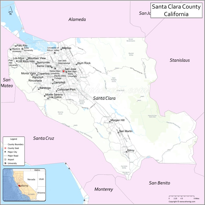
About Santa Clara County Map, California: The map showing the county boundary, county seat, major cities, highways, water bodies and neighbouring counties.
Most Viewed Links
About Santa Clara County, California
Santa Clara County is a county located in the San Francisco Bay Area of California, with its county seat in the city of San Jose. The county has an estimated population of over 1.9 million people as of 2021, making it the sixth most populous county in California. According to the United States Census Bureau, the county has a total area of 1,291 sq mi (3,344 km2). Santa Clara County was established on 1850.
Santa Clara County is known for its diverse economy, driven by a mix of industries including technology, healthcare, and education. The county is home to several major technology companies, including Apple, Google, and Facebook. Additionally, Santa Clara County is home to several prestigious universities and colleges, including Stanford University and Santa Clara University.
The county is also known for its natural beauty, with scenic parks, hiking trails, and historic landmarks. Some of the popular destinations in the county include the Winchester Mystery House, the Santa Clara Valley wine region, and the Tech Museum of Innovation.
Santa Clara County has a high quality of life, with a strong emphasis on environmental sustainability and social justice. The county has implemented several initiatives aimed at reducing greenhouse gas emissions, promoting clean energy, and improving public transportation. The county is also committed to addressing issues of equity and inclusion, with a focus on providing access to education and healthcare for all residents.
Overall, Santa Clara County offers a diverse and thriving economy, natural beauty, and a strong commitment to sustainability and social justice, making it a desirable place to live and work.
Facts about Santa Clara County, California
| Country | United States |
| State | California |
| Region | San Francisco Bay Area (South Bay / Silicon Valley) |
| County Seat | San Jose |
| Named After | Mission Santa Clara de Asís |
| Established | 1850 |
| Organized | 1850 |
| Coordinates | 37.2208° N, 121.6906° W |
| Total Area | 1,304 sq mi |
| Land Area | 1,290 sq mi |
| Water Area | 14 sq mi |
| Population (2020) | 1,936,259 |
| Population Rank | Second most populous county in California |
| Major Cities | San Jose, Sunnyvale, Santa Clara, Mountain View, Palo Alto |
| Main Industries | Technology, Software, Semiconductors, Biotechnology |
| Major Airport | Norman Y. Mineta San José International Airport |
| Time Zone | Pacific Time (UTC−08:00) |
| Known For | Silicon Valley, High-tech innovation, Major tech headquarters, Venture capital |
| Website | https://www.sccgov.org |
Ctities and Towns in Santa Clar County
| City Name | Type | Population (2020) | Pop. Density | Area | Incorporated |
|---|---|---|---|---|---|
| Campbell | City | 43,959 | 7,230.1/sq mi (2,791.6/km2) | 6.08 sq mi (15.7 km2) | March 28, 1952 |
| Cupertino | City | 60,381 | 5,329.3/sq mi (2,057.7/km2) | 11.33 sq mi (29.3 km2) | October 10, 1955 |
| Gilroy | City | 59,520 | 3,598.5/sq mi (1,389.4/km2) | 16.54 sq mi (42.8 km2) | March 12, 1870 |
| Los Altos | City | 31,625 | 4,835.6/sq mi (1,867.0/km2) | 6.54 sq mi (16.9 km2) | December 1, 1952 |
| Los Altos Hills | Town | 8,489 | 940.1/sq mi (363.0/km2) | 9.03 sq mi (23.4 km2) | January 27, 1956 |
| Los Gatos | Town | 33,529 | 2,902.9/sq mi (1,120.8/km2) | 11.55 sq mi (29.9 km2) | August 10, 1887 |
| Milpitas | City | 80,273 | 5,955.0/sq mi (2,299.2/km2) | 13.48 sq mi (34.9 km2) | January 26, 1954 |
| Monte Sereno | City | 3,479 | 2,134.4/sq mi (824.1/km2) | 1.63 sq mi (4.2 km2) | May 14, 1957 |
| Morgan Hill | City | 45,483 | 3,514.9/sq mi (1,357.1/km2) | 12.94 sq mi (33.5 km2) | November 10, 1906 |
| Mountain View | City | 82,376 | 6,887.6/sq mi (2,659.3/km2) | 11.96 sq mi (31 km2) | November 7, 1902 |
| Palo Alto | City | 68,572 | 2,845.3/sq mi (1,098.6/km2) | 24.1 sq mi (62.4 km2) | April 23, 1894 |
| San Jose | City | 1,013,240 | 5,684.1/sq mi (2,194.6/km2) | 178.26 sq mi (461.7 km2) | March 27, 1850 |
| Santa Clara | City | 127,647 | 6,982.9/sq mi (2,696.1/km2) | 18.28 sq mi (47.3 km2) | July 5, 1852 |
| Saratoga | City | 31,051 | 2,429.7/sq mi (938.1/km2) | 12.78 sq mi (33.1 km2) | October 22, 1956 |
| Sunnyvale | City | 155,805 | 7,062.8/sq mi (2,727.0/km2) | 22.06 sq mi (57.1 km2) | December 24, 1912 |
Places to Visit in Santa Clar County
Top places to visit in Santa Clara includes Levi's Stadium, Triton Museum of Art, Ulistac Natural Area, Rivermark Village, Montague Park, Anderson Lake County Park, Municipal Rose Garden, South Bay Shores, Santa Clara Central Park, Alum Rock Park, Baylands Park.
Highways in Santa Clar County
Interstate 280, Interstate 680, Interstate 880, U.S. Route 101, State Route 9, State Route 17, State Route 25, State Route 35, State Route 82, State Route 85, State Route 87, State Route 130, State Route 152, State Route 156, State Route 237.
Nearest Airports
Nearest airport of Santa Clar is San Jose (SJC) Airport.
- Alameda County Map
- Alpine County Map
- Amador County Map
- Butte County Map
- Calaveras County Map
- Colusa County Map
- Contra Costa County Map
- Del Norte County Map
- El Dorado County Map
- Fresno County Map
- Glenn County Map
- Humboldt County Map
- Imperial County Map
- Inyo County Map
- Kern County Map
- Kings County Map
- Lake County Map
- Lassen County Map
- Los Angeles County Map
- Madera County Map
- Marin County Map
- Mariposa County Map
- Mendocino County Map
- Merced County Map
- Modoc County Map
- Mono County Map
- Monterey County Map
- Napa County Map
- Nevada County Map
- Orange County Map
- Placer County Map
- Plumas County Map
- Riverside County Map
- Sacramento County Map
- San Benito County Map
- San Bernardino County Map
- San Diego County Map
- San Francisco County Map
- San Joaquin County Map
- San Luis Obispo County Map
- San Mateo County Map
- Santa Barbara County Map
- Santa Clara County Map
- Santa Cruz County Map
- Shasta County Map
- Sierra County Map
- Siskiyou County Map
- Solano County Map
- Sonoma County Map
- Stanislaus County Map
- Sutter County Map
- Tehama County Map
- Trinity County Map
- Tulare County Map
- Tuolumne County Map
- Ventura County Map
- Yolo County Map
- Yuba County Map
- Alabama Counties
- Alaska boroughs
- Arizona Counties
- Arkansas Counties
- California County Map
- Colorado Counties
- Connecticut Counties
- Delaware Counties
- Florida County Map
- Georgia County Map
- Hawaii Counties
- Idaho Counties
- Illinois Counties
- Indiana Counties
- Iowa Counties
- Kansas Counties
- Kentucky Counties
- Louisiana Counties
- Maine Counties
- Maryland Counties
- Massachusetts Counties
- Michigan County Map
- Minnesota Counties
- Mississippi Counties
- Missouri Counties
- Montana Counties
- Nebraska Counties
- Nevada Counties
- New York Counties
- New Hampshire Counties
- New Jersey Counties
- New Mexico Counties
- North Carolina Counties
- North Dakota Counties
- Ohio County Map
- Oklahoma Counties
- Oregon Counties
- Pennsylvania Counties
- Rhode Island Counties
- South Carolina Counties
- South Dakota Counties
- Map of Tennessee
- Texas County Map
- Utah Counties
- Vermont Counties
- Virginia Counties
- Washington Counties
- West Virginia Counties
- Wisconsin Counties
- Wyoming Counties