Written and fact-checked by Whereig.com Web Team | Last Updated: December 16, 2025, 14:30 ET
Map of Yolo County - Yolo County is a county located in the U.S. state of California. Yolo County Map showing cities, highways, important places and water bodies. Get Where is Yolo County located in the map, major cities in Yolo county, population, areas, and places of interest.
Yolo County Map, California
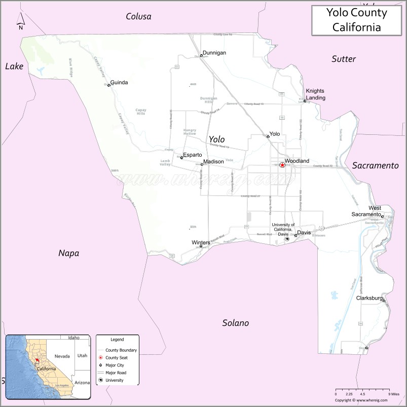
About Yolo County Map, California: The map showing the county boundary, county seat, major cities, highways, water bodies and neighbouring counties.
Most Viewed Links
Yolo County Facts, California
| Country | United States |
| State | California |
| Region | Northern California (Sacramento Valley) |
| County Seat | Woodland |
| Named After | Yolo Native American tribe |
| Established | 1850 |
| Organized | 1850 |
| Coordinates | 38.6786° N, 121.7733° W |
| Total Area | 1,024 sq mi |
| Land Area | 1,015 sq mi |
| Water Area | 9 sq mi |
| Population (2020) | 216,403 |
| Population Rank | Mid-sized county in California |
| Major Cities | Woodland, Davis, West Sacramento, Winters |
| Main Industries | Agriculture, Education, Government Services, Biotechnology |
| Major Airport | Watts–Woodland Airport |
| Time Zone | Pacific Time (UTC−08:00) |
| Known For | University of California, Davis, Agricultural research, Sacramento River, Farmland |
| Website | https://www.yolocounty.org |
Explore Map of California Counties
- Alameda County Map
- Alpine County Map
- Amador County Map
- Butte County Map
- Calaveras County Map
- Colusa County Map
- Contra Costa County Map
- Del Norte County Map
- El Dorado County Map
- Fresno County Map
- Glenn County Map
- Humboldt County Map
- Imperial County Map
- Inyo County Map
- Kern County Map
- Kings County Map
- Lake County Map
- Lassen County Map
- Los Angeles County Map
- Madera County Map
- Marin County Map
- Mariposa County Map
- Mendocino County Map
- Merced County Map
- Modoc County Map
- Mono County Map
- Monterey County Map
- Napa County Map
- Nevada County Map
- Orange County Map
- Placer County Map
- Plumas County Map
- Riverside County Map
- Sacramento County Map
- San Benito County Map
- San Bernardino County Map
- San Diego County Map
- San Francisco County Map
- San Joaquin County Map
- San Luis Obispo County Map
- San Mateo County Map
- Santa Barbara County Map
- Santa Clara County Map
- Santa Cruz County Map
- Shasta County Map
- Sierra County Map
- Siskiyou County Map
- Solano County Map
- Sonoma County Map
- Stanislaus County Map
- Sutter County Map
- Tehama County Map
- Trinity County Map
- Tulare County Map
- Tuolumne County Map
- Ventura County Map
- Yolo County Map
- Yuba County Map
US Counties Map by State
- Alabama Counties
- Alaska boroughs
- Arizona Counties
- Arkansas Counties
- California County Map
- Colorado Counties
- Connecticut Counties
- Delaware Counties
- Florida County Map
- Georgia County Map
- Hawaii Counties
- Idaho Counties
- Illinois Counties
- Indiana Counties
- Iowa Counties
- Kansas Counties
- Kentucky Counties
- Louisiana Counties
- Maine Counties
- Maryland Counties
- Massachusetts Counties
- Michigan County Map
- Minnesota Counties
- Mississippi Counties
- Missouri Counties
- Montana Counties
- Nebraska Counties
- Nevada Counties
- New York Counties
- New Hampshire Counties
- New Jersey Counties
- New Mexico Counties
- North Carolina Counties
- North Dakota Counties
- Ohio County Map
- Oklahoma Counties
- Oregon Counties
- Pennsylvania Counties
- Rhode Island Counties
- South Carolina Counties
- South Dakota Counties
- Map of Tennessee
- Texas County Map
- Utah Counties
- Vermont Counties
- Virginia Counties
- Washington Counties
- West Virginia Counties
- Wisconsin Counties
- Wyoming Counties