Indiana, one of the 50 US states, is located in the Mid-Atlantic region in the northeast part of the United States. It's lies at a latitude of 39.0458° N, and a longitude of 76.6413° W.
Location Map of Indiana State
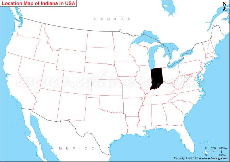
 About Map: Map showing location of Indiana in the US Map.
Indiana Maps & Info
Where is Indiana Located?
As you can see on the given location map of Indiana state US, Indiana is located in the Great Lakes Region of USA. However, the Indiana state US shares its boundary with Michigan in north, Ohio in the east, Kentucky in the south and south-east, and Illinois in the west. The Small portion of northern part of the Indiana US makes coastline with Lake Michigan; the coastline with Lake Michigan facilitates the state with see route.
Indiana is the 19th state that admitted to the Union. The state has many cities with the population more than 100,000 along with several small industrial cities and towns. As you can see on the Indiana map US, the capital city of state is Indianapolis. It is the largest city of the state. The state is special in terms of sports; it is more popularly known as home of many important sports including NBA’s Indiana Pacers, NFL’s Indianapolis Colts, and the Indianapolis 500 motor-sports race (surprisingly, it is largest single-day sporting event in the entire world).
The state has humid continental climate with some percentage of agriculture land. However, the state is also important for the tourists and education. The cities like Indianapolis, Evansville, Fort Wayne, South Bend, Gary and many others are very much significant for the tourists. The locations of these cities, you can find on the Indiana state map. This is detailed map of Indiana US that comprises wide range of information including major and small cities, railways, and highways. It is very much beneficial for tourists, students, teachers, and other people who are interested in knowing about Indiana state US.
Indiana State Facts
| Country: | United States |
| Region Type: | State |
| Capital: | Indianapolis |
| Abbreviation: | IN, Ind. US-IN |
| Largest City: | Indianapolis |
| Area: | 36,418 sq mi (94,321 km2) |
| Population: | 6,570,902 (2013 est) |
| Joined The Union: | December 11, 1816 (19th) |
| Nickname: | Hoosier State |
| Highest Point: | Hoosier Hill |
| Lowest Point: | Confluence of Ohio River and Wabash River |
| Timezone: | Eastern: UTC −5/−4, Central: UTC −6/−5 |
| Official Website: | https://www.in.gov/ |
- Where is Akron
- Where is Anaheim
- Where is Anchorage
- Where is Arlington
- Where is Aurora
- Where is Baltimore
- Where is Baton Rouge
- Where is Birmingham
- Where is Boise City
- Where is Boston
- Where is Buffalo
- Where is Chandler
- Where is Charlotte
- Where is Chesapeake
- Where is Chula Vista
- Where is Cincinnati
- Where is Cleveland
- Where is Colorado Springs
- Where is Columbus
- Where is Corpus Christi
- Where is Des Moines
- Where is Detroit
- Where is Durham
- Where is El Paso
- Where is Fayetteville
- Where is Fort Wayne
- Where is Freemont
- Where is Fresno
- Where is Garland
- Where is Gilbert
- Where is Glendale
- Where is Greensboro
- Where is Henderson
- Where is Hialeah
- Where is Honolulu
- Where is Houston
- Where is Indianapolis
- Where is Irvine
- Where is Irving
- Where is Jacksonville
- Where is Jersey City
- Where is Kansas City
- Where is Laredo
- Where is Lincoln
- Where is Long Beach
- Where is Louisville
- Where is Lubbock
- Where is Madison
- Where is Memphis
- Where is Mesa
- Where is Milwaukee
- Where is Minneapolis
- Where is Modesto
- Where is Montgomery
- Where is Nashville
- Where is Newark
- Where is Norfolk
- Where is North Las Vegas
- Where is Oakland
- Where is Oklahoma City
- Where is Omaha
- Where is Orlando
- Where is Paradise
- Where is Philadelphia
- Where is Phoenix
- Where is Portland
- Where is Raleigh
- Where is Reno
- Where is Richmond
- Where is Riverside
- Where is Rochester
- Where is Sacramento
- Where is Saint Paul
- Where is Saint Petersburg
- Where is San Bernardino
- Where is San Jose
- Where is Santa Ana
- Where is Scottsdale
- Where is Shreveport
- Where is Spokane
- Where is St Louis
- Where is Stockton
- Where is Tampa
- Where is Toledo
- Where is Tucson
- Where is Tulsa
- Where is Virginia Beach
- Where is Wichita
