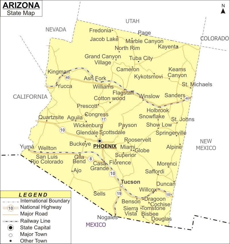
Arizona, is the sixth most extensive state in USA. The capital city is Phoenix. It is situated in the South-West region of the USA.
Map of Arizona with Cities, Road, River, Highways
 About Map: Arizona Map showing the capital, state boundary, roads, rail network,rivers, interstate highways, major cities and towns.
Most Viewed Links
About Arizona State Map
Arizona, the 48th state of the U.S., is situated in the southwestern parts of the country. Arizona is a large state and encompasses a total land area of 113,998 sq miles, ranking as the sixth biggest state in the country. The Grand Canyon State shares its boundaries with California, Nevada, New Mexico, Utah, Colorado, and the Mexican province of Sonora. An Arizona Map is the ideal means to experience the varied natural beauties of the state. The capital and largest city of the state is Phoenix.
The US state of Arizona is situated in the southwestern region. However, it can also be called a part of the mountain west and western United States region. More such relevant information on Arizona is available in any map of Arizona.
The capital and biggest city of Arizona is Phoenix and Tucson is the second largest city. Some of the other large cities in this southwestern state are Mesa, Gilbert, Glendale, Tempe, Chandler, Peoria, Scottsdale, Surprise and Yuma. Arizona is the 48th state of USA and was the final neighboring state to have been added to the Union. It achieved statehood on 14th February 1912. With regards to population it is the biggest landlocked state in USA. In addition to the Grand Canyon, there are a number of national forests, monuments and parks in Arizona.
At least 25% of the territory in Arizona serves as the Federal Trust Land. Apart from the Navajos there are a number of other indigenous tribes in this state such as the Hopi tribe, Yavapai, Tohono O'odham, Quechan, Apache and Hualapai.
Tourist attractions in Arizona
National Parks
|
- Glen Canyon National Recreation Area
National Monuments
|
National Forests
|
Arizona Interstates
North-South interstates: Interstate 15, Interstate 17 and Interstate 19.East-West interstates: Interstate 8, Interstate 10 and Interstate 40.
Arizona Routes
US Highways and State Routes are: Route 60, Route 70, Route 89, Route 89A, Route 93, Route 95, Route 160, Route 180 and Route 191.Arizona State Facts
| State Name | Arizona |
| Capital City | Phoenix |
| Lagest city | Phoenix |
| Abbreviation | AZ, Ariz. US-AZ |
| Joined the Union | February 14, 1912 (48th) |
| Nickname | Grand Canyon State |
| area | 113,990sq mi (295,234 km2) |
| Timezone | Mountain: UTC-7 |
| Population | 6,626,624 (2013 est) |
| Highest Point | Humphreys Peak |
| Lowest Point | Colorado River |
| Official Website | https://www.az.gov/ |
- Where is Akron
- Where is Anaheim
- Where is Anchorage
- Where is Arlington
- Where is Aurora
- Where is Baltimore
- Where is Baton Rouge
- Where is Birmingham
- Where is Boise City
- Where is Boston
- Where is Buffalo
- Where is Chandler
- Where is Charlotte
- Where is Chesapeake
- Where is Chula Vista
- Where is Cincinnati
- Where is Cleveland
- Where is Colorado Springs
- Where is Columbus
- Where is Corpus Christi
- Where is Des Moines
- Where is Detroit
- Where is Durham
- Where is El Paso
- Where is Fayetteville
- Where is Fort Wayne
- Where is Freemont
- Where is Fresno
- Where is Garland
- Where is Gilbert
- Where is Glendale
- Where is Greensboro
- Where is Henderson
- Where is Hialeah
- Where is Honolulu
- Where is Houston
- Where is Indianapolis
- Where is Irvine
- Where is Irving
- Where is Jacksonville
- Where is Jersey City
- Where is Kansas City
- Where is Laredo
- Where is Lincoln
- Where is Long Beach
- Where is Louisville
- Where is Lubbock
- Where is Madison
- Where is Memphis
- Where is Mesa
- Where is Milwaukee
- Where is Minneapolis
- Where is Modesto
- Where is Montgomery
- Where is Nashville
- Where is Newark
- Where is Norfolk
- Where is North Las Vegas
- Where is Oakland
- Where is Oklahoma City
- Where is Omaha
- Where is Orlando
- Where is Paradise
- Where is Philadelphia
- Where is Phoenix
- Where is Portland
- Where is Raleigh
- Where is Reno
- Where is Richmond
- Where is Riverside
- Where is Rochester
- Where is Sacramento
- Where is Saint Paul
- Where is Saint Petersburg
- Where is San Bernardino
- Where is San Jose
- Where is Santa Ana
- Where is Scottsdale
- Where is Shreveport
- Where is Spokane
- Where is St Louis
- Where is Stockton
- Where is Tampa
- Where is Toledo
- Where is Tucson
- Where is Tulsa
- Where is Virginia Beach
- Where is Wichita
