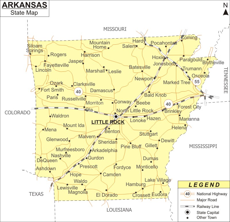
About Map: Arkansas Map showing the capital, state boundary, roads, rail network,rivers, interstate highways, major cities and towns.
Arkansas Map: Arkansas is a state in the region of South Central America. It is a landlocked state. It shares the borders with Missouri to the north, to the east Tennessee and Mississippi, to the south Louisiana, to the west Texas and Oklahoma. Its name refers to the Quapaw people, who are related to the Osage and speak a Dhegiha Siouan language. The unique geography of the state includes the rugged Ozark and Ouachita Mountain ranges, which are part of the U.S. Interior Highlands, as well as the thickly forested Arkansas Timberlands in the south and the eastern lowlands along the Mississippi River and the Arkansas Delta.
Arkansas Map
All of the locations within the state are shown on the Arkansas Map that is available on this website. The Arkansas Map displays not only the borders but also major roads, railway tracks, the state capital, and other towns. The Arkansas Map can be used to locate various areas the searcher wants to find out. The Arkansas Map, which is provided on this website, is free. Anyone can download the Arkansas Map from here.
Arkansas Map Depicts the Major Cities:
The major cities of Arkansas are given in the Arkansas map. The major cities of Arkansas are Little Rock, Fayetteville, Fort Smith, Springdale, Jonesboro, Rogers, Conway, North Little Rock, Bentonville, and Pine Bluff. Other cities like Arkadelphia, Benton, Blytheville, Cabot, Camden, Conway, El Dorado, Forrest City, Harrison, Hot Springs, Jacksonville, Magnolia, Mountain Home, North Little Rock, Paragould, Pine Bluff, Russellville, Searcy, Sherwood, Siloam Springs, Texarkana, Van Buren and West Memphis are given in the Arkansas Map.
Arkansas Map Indicates National Highways & Routes:
The Arkansas Map also indicates North-South interstates, which includes Interstate 55. East-West interstates include interstate 30 and Interstate 40. US Highways and State Routes included in the state of Arkansas are Route 49, Route 62, Route 63, Route 64, Route 65, Route 67, Route 70, Route 71, Route 79, Route 82, Route 165, Route 167, Route 270, Route 412 and Route 425.
Facts About Arkansas
| State Name | Arkansas |
| Capital City | Little Rock |
| Lagest city | Little Rock |
| Abbreviation | AR, Ark US-AR |
| Joined the Union | June 15, 1836 (25th) |
| Nickname | The Natural State |
| area | 53,179 sq mi (137,733 km2) |
| Timezone | Central: UTC −6/−5 |
| Population | 2,949,131 (2012 est) |
| Highest Point | Magazine Mountain |
| Lowest Point | Ouachita River |
| Official Website | https://www.arkansas.gov/ |
Location Map of USA with States
- Where is Alabama (AL)
- Where is Alaska
- Where is Arizona
- Where is Arkansas Location Mapp
- Where is California
- Where is Colorado
- Where is Connecticut
- Where is Delaware
- Where is Florida
- Where is Georgia
- Where is Hawaii
- Where is Idaho State Map
- Where is Illinois
- Where is Indiana
- Where is Iowa
- Where is Kansas
- Where is Kentucky
- Where is Louisiana
- Where is Maine
- Where is Maryland
- Where is Massachusetts
- Where is Michigan
- Where is Minnesota
- Where is Mississippi
- Where is Missouri
- Where is Montana
- Where is Nebraska
- Where is Nevada
- Where is New Hampshire
- Where is New Jersey
- Where is New Mexico
- Where is New York
- Where is North Carolina
- Where is North Dakota
- Where is Ohio
- Where is Oklahoma
- Where is Oregon
- Where is Pennsylvania
- Where is Rhode Island
- Where is South Carolina
- Where is South Dakota
- Where is Tennessee
- Where is Texas
- Where is Utah
- Where is Vermont
- Where is Virginia
- Where is Washington
- Where is West Virginia
- Where is Wisconsin
- Where is Wyoming


