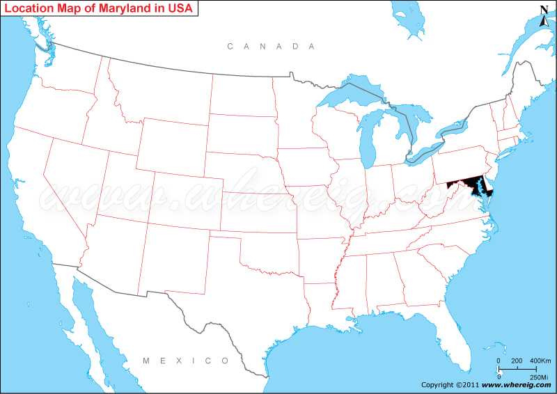
Maryland, one of the 50 US states, is located in the Mid-Atlantic region in the northeast part of the United States. It's lies at a latitude of 39.0458° N, and a longitude of 76.6413° W.
Location Map of Maryland State

More Maryland Maps & Info
Where is Maryland Located?
Maryland US is a small state; as shown on the given Maryland location map that Maryland is located in the north-east region of the US along the Atlantic coast. If you see the given map of Maryland, you will find it that the state makes boundary with Virginia, West Virginia and the District of Columbia to its south and west accordingly; Delaware lies in the east and Pennsylvania to its north.
The interesting fact about Maryland US is – it is a significant center for life sciences research and development. Surprisingly, the state has more than 350 biotechnology companies. There are many institutions and government agencies in the state for the research and development work in the state; significant of them are Johns Hopkins University, Johns Hopkins Applied Physics Laboratory, National Institute of Standards and Technology, the Federal Food and Drug Administration (FDA), the National Institute of Mental Health (NIMH), Human Genome Sciences (HGS), Howard Hughes Medical Institute and many more.
In addition, the Maryland state US has variable climate and coastal location; hence, it has also attractions for the tourists. There are some of the panoramic cities that have many several Maryland tourists’ attractions; important of them are Annapolis (capital city shown on the Maryland Map), Baltimore, Bethesda, Bowie, Chesapeake City, Cumberland, Ocean City, Rockville and many others. These Maryland cities as you can see on the given Maryland state map US have perfect locations and ideal climate four tourisms. Moreover, the given Maryland map US also gives the details for the railways and roadways that are very help for finding the rout and city location for everyone.
Maryland State Facts
| Maryland Location: | North-east part of the US |
| Maryland Coordinates: | 39.0458° N, 76.6413° W |
| Country: | United States |
| Region Type: | State |
| Capital: | Annapolis |
| Abbreviation: | MD, US-MD |
| Largest City: | Baltimore |
| Area: | 12,407 sq mi (32,133 km2) [42nd] |
| Population: | 6,177,224 [19th] (2020 Census) |
| Pop Density: | 619/sq mi (238/km2) |
| Joined The Union: | April 28, 1788 (7th) |
| Nickname: | Old Line State |
| Highest Point: | Hoye-Crest |
| Lowest Point: | Atlantic Ocean |
| Timezone: | Eastern: UTC −5/−4 |
| Official Website: | www.maryland.gov |
- Where is Annapolis
- Where is Aspen Hill
- Where is Bel Air North
- Where is Bel Air South
- Where is Baltimore
- Where is Bethesda
- Where is Bowie
- Where is Carney
- Where is Catonsville
- Where is Chillum
- Where is Clarksburg
- Where is Clinton
- Where is College Park
- Where is Columbia
- Where is Crofton
- Where is Dundalk
- Where is Eldersburg
- Where is Elkridge
- Where is Ellicott City
- Where is Essex
- Where is Frederick
- Where is Gaithersburg
- Where is Germantown
- Where is Glen Burnie
- Where is Hagerstown
- Where is Laurel
- Where is Middle River
- Where is Milford Mill
- Where is Montgomery Village
- Where is North Bethesda
- Where is North Laurel
- Where is Odenton
- Where is Olney
- Where is Owings Mills
- Where is Parkville
- Where is Pasadena
- Where is Perry Hall
- Where is Pikesville
- Where is Potomac
- Where is Randallstown
- Where is Rockville
- Where is Salisbury
- Where is Severn
- Where is Severna Park
- Where is Silver Spring
- Where is South Laurel
- Where is Towson
- Where is Waldorf
- Where is Wheaton
- Where is Woodlawn
