Located in the Midwestern United States, Iowa is often referred to as the "American Heartland". Iowa is also known as the "Food Capital of the World". Its capital and largest city is Des Moines.
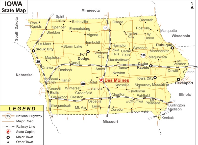
Map of Iowa with Cities, Road, River, Highways

About Map: Iowa Map showing the capital, state boundary, roads, rail network,rivers, interstate highways, major cities and towns.
More Iowa Maps & Info
| Iowa Map | Iowa County Map | Iowa Cities Map |
| Iowa Zipcodes | Where is Iowa | Airports in Iowa |
| Iowa Area Codes | Iowa Blank Map | Iowa River Map |
| Iowa Physical Map | Iowa Road Map | Where is Where is Des Moines |
About Iowa
Iowa is the 26th biggest state in the United States. The State of Iowa is located to the west of the Mississippi River, in the Midwestern part of the United States. The state of Iowa is known for its delicious cuisines, welcoming nature of the residents, and its blend of urban and rural tradition. The capital of IA is Des Moines and it is also the biggest city of the state. There are many hotels in Iowa to suit the needs of vacationers. The main airport of IA is Des Moines International Airport.
Iowa is the 29th state of the United States. It is frequently called as the "American Heartland". The capital and biggest city of IA is Des Moines and the state covers a total land area of 56,272 sq miles. It has common boundaries with Wisconsin, Minnesota, Missouri, Illinois, South Dakota, and Nebraska. The major rivers flow through the State are The Missouri River, Iowa River, Des Moines River and Cedar River.
Tourist attractions in Iowa
The state of IA houses a range of tourist destinations, which include the following:
- Cedar Falls - It is closely located to Waterloo and houses the University of Northern Iowa
- Ames - It is famous for the Iowa State University and is located to the north of Des Moines
- Council Bluffs - It is a famous Western metropolitan area on the banks of the Missouri River
- Cedar Rapids - Second biggest city in the state
- Dubuque - The city is famous for its mountains and lies close to the Mississippi River
- Des Moines - Capital and largest city of the state. It is nicknamed as the "Insurance Capital of the United States".
- Quad Cities - Fifty percent of Bettendorf and Davenport is situated in Iowa, and the rest lies in Illinois.
- Iowa City - Famous for the University of Iowa. It is closely located to the Cedar Rapids.
- Sioux City - A famous city beside the Missouri River in the northwest.
Iowa Airports & Airlines
The Eastern Iowa Airport, Des Moines International Airport, Eppley Airfield (Nebraska), and Quad City International Airport (Illinois) are the major airports serving the state. AirTran Airways, Allegiant Air, Continental Airlines, Delta Airlines, Frontier Airlines, United Express, and US Airways are the main carriers.
Economy of Iowa
Frequently referred to as the "Food Capital of the World", Iowa has an agriculture-oriented economy. Sectors like biotechnology, food processing, manufacturing, insurance and financial services, and federal jobs make a huge contribution to the economy of the state.
Facts About Iowa
| State Name | Iowa |
| Country | United States |
| Continent | North America |
| Capital City | Des Moines |
| Largest city | Des Moines |
| Abbreviation | IA, US-IA |
| Joined the Union | December 28, 1846 (29th) |
| Nickname | The Hawkeye State |
| Area | 56,272 sq mi (145,743 km2) |
| Timezone | Central: UTC -6/-5 |
| Population | 3,090,416 (2013 est) |
| Highest Point | Hawkeye Point |
| Lowest Point | Confluence of Mississippi River and Des Moines River |
| Official Website | https://www.iowa.gov/ |
Iowa Interstates
North-South interstates include: Interstate 15, Interstate 17 and Interstate 19. East-West interstates include: Interstate 8, Interstate 10 and Interstate 40.
Iowa Routes
US Highways and State Routes include: Route 60, Route 70, Route 89, Route 89A, Route 93, Route 95, Route 160, Route 180 and Route 191.
US Zip Codes by State - Click on State name for its Zip Codes
- Alabama Zip Codes
- Alaska Zip Codes
- Arizona Zip Codes
- Arkansas Zip Codes
- California Zip Codes
- Colorado Zip Codes
- Connecticut Zip Codes
- Delaware Zip Codes
- Florida Zip Codes
- Georgia Zip Codes
- Hawaii Zip Codes
- Idaho Zip Codes
- Illinois Zip Codes
- Indiana Zip Codes
- Iowa Zip Codes
- Kansas Zip Codes
- Kentucky Zip Codes
- Louisiana Zip Codes
- Maine Zip Codes
- Maryland Zip Codes
- Massachusetts Zip Codes
- Michigan Zip Codes
- Minnesota Zip Codes
- Mississippi Zip Codes
- Missouri Zip Codes
- Montana Zip Codes
- Nebraska Zip Codes
- Nevada Zip Codes
- New Hampshire Zip Codes
- New Jersey Zip Codes
- New Mexico Zip Codes
- New York Zip Codes
- North Carolina Zip Codes
- North Dakota Zip Codes
- Ohio Zip Codes
- Oklahoma Zip Codes
- Oregon Zip Codes
- Pennsylvania Zip Codes
- Rhode Island Zip Codes
- South Carolina Zip Codes
- South Dakota Zip Codes
- Tennessee Zip Codes
- Texas Zip Codes
- Utah Zip Codes
- Vermont Zip Codes
- Virginia Zip Codes
- Washington Zip Codes
- West Virginia Zip Codes
- Wisconsin Zip Codes
- Wyoming Zip Codes
