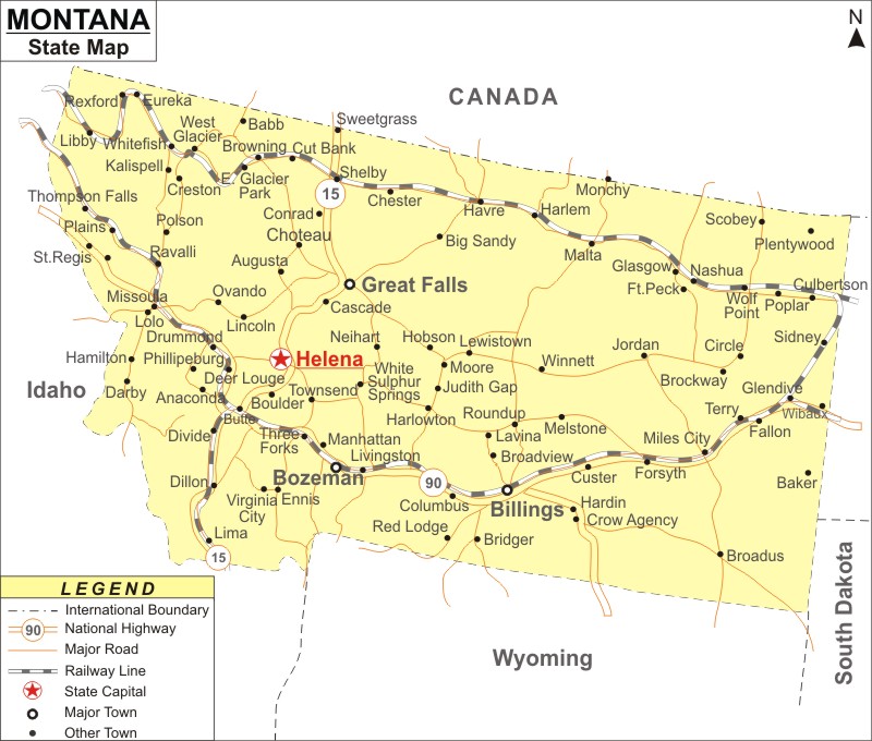
Montana Map: Montana is a state in the Mountain West region of the Western US. Montana is the the 43rd most populous and 4th largest U.S. state in area. It covers an area of 147,040 sq mi (380,800 km2), with population of 1,084,225 people according to the 2020 US Census .
Map of Montana with Cities, Road, River, Highways
 About Map: Montana Map showing the capital, state boundary, roads, rail network,rivers, interstate highways, major cities and towns.
Montana More Maps & Info
About Montana State Map
The state of Montana is located in the Mountain West region of the Western US. It shares borders with the Canadian provinces of Alberta, British Columbia, and Saskatchewan to the north, Idaho to the west, North Dakota and South Dakota to the east, Wyoming to the south, and North and South Dakotas. These borders can be witnessed in the Montana map. It is the eighth-least populous, third-least densely populated and fourth-largest state in terms of area. Helena serves as the state capital, and Billings is the largest city. While the eastern half of Montana is defined by the badlands and western grassland, the western half of the state is home to multiple mountain ranges, with lesser mountain ranges dispersed across the state.
Montana Map
The state of Montana is depicted on a stunningly accurate Montana map, along with its borders, the location of Helena , its capital, important cities and other populous areas, rivers and lakes, important highways, interstates, railroads, and airports. You can download the Montana map from this page which is offered at free of cost and use it for your purpose.
Montana Map Illustrates Major Cities
Montana Map shows the major cities of the state like Miles City, Livingston, Evergreen, Butte-Silver Bow, Kalispell, Belgrade, Havre, Anaconda-Deer Lodge County, Missoula, Great Falls, Bozeman, Missoula Valley Southeast, Bozeman, Butte-Silver Bow, Helena, Polson, Glendive, Bigfork Helena Valley Northwest, Hamilton, Lolo, Malmstrom AFB, Whitefish, Laurel, Lockwood, Sidney, Lewistown, Four Corners, Columbia Falls, Orchard Homes, etc. are some of the major cities in Montana. Montana map gives a clear geographical location of all these cities in the state along with the other towns.
Montana Map Indicates National Highways & Routes of the State
The Montana Map depicts all of the National Highways and Routes, which serve as the State's transportation network. The details of National Highways and Routes are provided below.
Facts About Montana
| State Name | Montana |
| Country | United States |
| Continent | North America |
| Capital City | Helena |
| Largest city | Billings |
| Abbreviation | MT, Mont. US-MT |
| Joined the Union | November 8, 1889 (41st) |
| Nickname | Big Sky Country, The Treasure State, Land of the Shining Mountains, The Last Best Place |
| Area | 147,040 sq mi (380,800 km2) |
| Timezone | Mountain: UTC -7/-6 |
| Population | 1,084,225(2020 Census) |
| Highest Point | Granite Peak |
| Lowest Point | Kootenai River at Idaho borde |
| Official Website | www.mt.gov |
