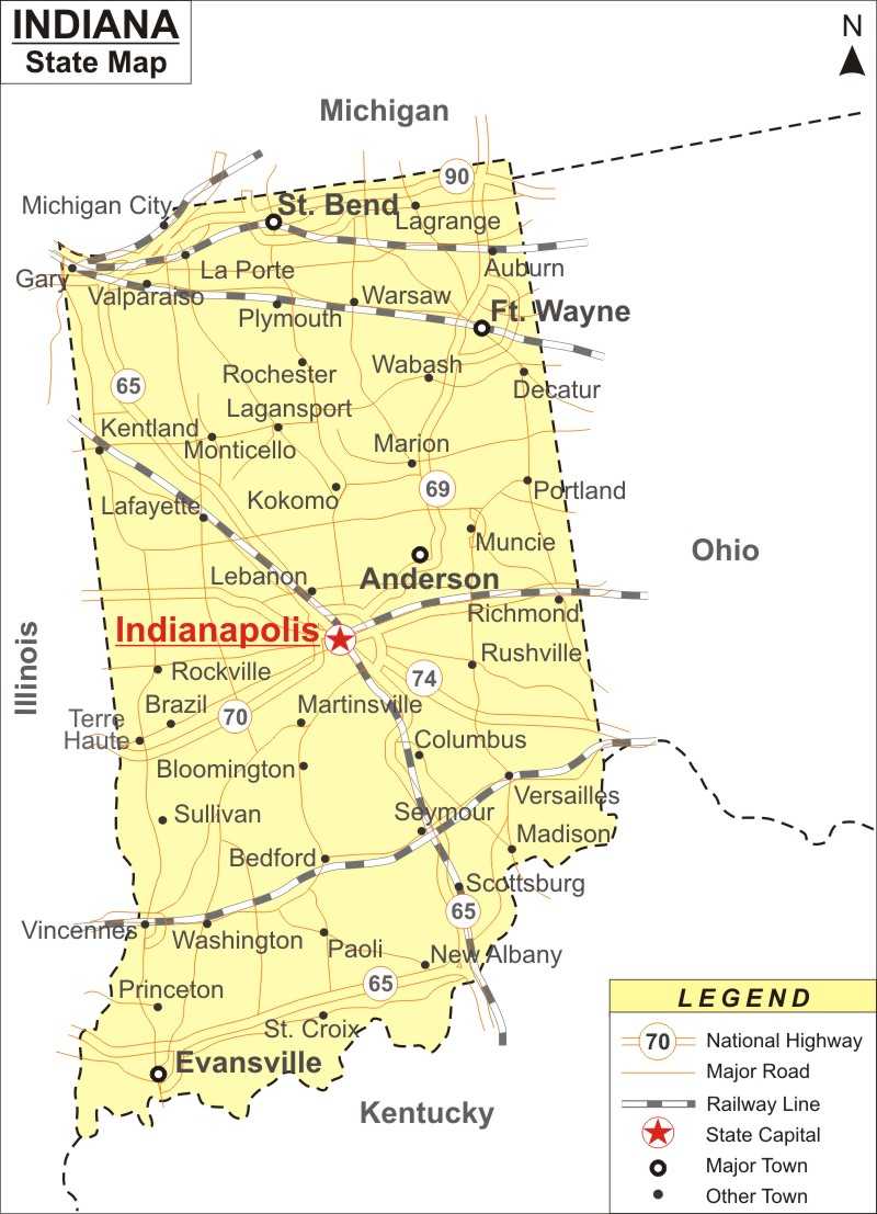
Indiana is in the Midwestern and Great Lakes regions in North America. It is the 15th most populous state of all the 50 states in US. The capital of Indiana is Indianapolis.
Indiana State Map
 About Map: Indiana Map showing the capital, state boundary, roads, rail network,rivers, interstate highways, major cities and towns.
Indiana Maps & Info
About Indiana
Indiana, the 19th state of the United States, is situated in the Midwestern region of the country. The state is famous for its sport teams and higher educational institutions. The state of IN covers a total area of 36,418 sq miles. The bordering states of Indiana are Kentucky, Ohio, Michigan, and Illinois. An Indiana Map can guide the visitors to every nook and corner of The Hoosier State. The capital and largest city of the state is Indianapolis.
About Indiana Map
The exact location of the state, which is on the eastern corner of north-central United States, is shown in the map. The map also locates the rivers and lakes. Indianapolis, the capital city, is prominently marked. Towns like Anderson, Evansville, Ft. Wayne and St. Bend are also shown along with their respective geographical standing. Other cities and towns such as Scottsburg, Rockville, Madison, Princeton, Kokomo, New Albany, Martinsville, Marion, Lagrange, Gary, Lafayette, Rushville, Bloomington, Monticello, Decatur, and several others are indicated in the Indiana map. The extensive road network of 93,606 miles is vividly marked. Also, the railway routes that collectively cover 4,685 miles are shown on the Indiana map. As a whole, the map offers an all-encompassing overview of the state, especially for those that are visiting for the first time, and is a significant illustrative guide that provides a lot of information regarding the area.
Cities in Indiana
The state of IN houses the following popular tourist destinations:Famous tourist spots include Chain O' Lakes State Park, Brown County State Park, Hoosier National Forest, George Rogers Clark National Historical Park, John Mellencamp's Mansion, Indiana Dunes National Lakeshore, Prophetstown State Park, Lincoln Boyhood National Memorial, and Turkey Run State Park.
Indiana Interstates
North-South interstates include: Interstate 15, Interstate 17 and Interstate 19. East-West interstates include: Interstate 8, Interstate 10 and Interstate 40.
Indiana Routes
US Highways and State Routes include: Route 60, Route 70, Route 89, Route 89A, Route 93, Route 95, Route 160, Route 180 and Route 191.
Indiana State Information
| State Name | Indiana |
| Country | United States |
| Continent | North America |
| Capital City | Indianapolis |
| Largest city | Indianapolis |
| Abbreviation | IN, Ind. US-IN |
| Joined the Union | December 11, 1816 (19th) |
| Nickname | Hoosier State |
| Area | 36,418 sq mi (94,321 km2) |
| Timezone | Eastern: UTC −5/−4, Central: UTC −6/−5 |
| Population | 6,570,902 (2013 est) |
| Highest Point | Hoosier Hill |
| Lowest Point | Confluence of Ohio River and Wabash River |
| Official Website | https://www.in.gov/ |
- Where is Akron
- Where is Anaheim
- Where is Anchorage
- Where is Arlington
- Where is Aurora
- Where is Baltimore
- Where is Baton Rouge
- Where is Birmingham
- Where is Boise City
- Where is Boston
- Where is Buffalo
- Where is Chandler
- Where is Charlotte
- Where is Chesapeake
- Where is Chula Vista
- Where is Cincinnati
- Where is Cleveland
- Where is Colorado Springs
- Where is Columbus
- Where is Corpus Christi
- Where is Des Moines
- Where is Detroit
- Where is Durham
- Where is El Paso
- Where is Fayetteville
- Where is Fort Wayne
- Where is Freemont
- Where is Fresno
- Where is Garland
- Where is Gilbert
- Where is Glendale
- Where is Greensboro
- Where is Henderson
- Where is Hialeah
- Where is Honolulu
- Where is Houston
- Where is Indianapolis
- Where is Irvine
- Where is Irving
- Where is Jacksonville
- Where is Jersey City
- Where is Kansas City
- Where is Laredo
- Where is Lincoln
- Where is Long Beach
- Where is Louisville
- Where is Lubbock
- Where is Madison
- Where is Memphis
- Where is Mesa
- Where is Milwaukee
- Where is Minneapolis
- Where is Modesto
- Where is Montgomery
- Where is Nashville
- Where is Newark
- Where is Norfolk
- Where is North Las Vegas
- Where is Oakland
- Where is Oklahoma City
- Where is Omaha
- Where is Orlando
- Where is Paradise
- Where is Philadelphia
- Where is Phoenix
- Where is Portland
- Where is Raleigh
- Where is Reno
- Where is Richmond
- Where is Riverside
- Where is Rochester
- Where is Sacramento
- Where is Saint Paul
- Where is Saint Petersburg
- Where is San Bernardino
- Where is San Jose
- Where is Santa Ana
- Where is Scottsdale
- Where is Shreveport
- Where is Spokane
- Where is St Louis
- Where is Stockton
- Where is Tampa
- Where is Toledo
- Where is Tucson
- Where is Tulsa
- Where is Virginia Beach
- Where is Wichita
