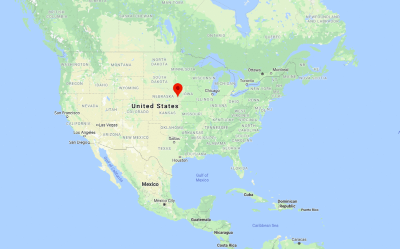
Omaha is located in the eastern part of the state. It is the largest city in the state of Nebraska.
Omaha, Nebraska Quick Facts
| Fact | Details |
|---|---|
| City | Omaha |
| County | Douglas County |
| State | Nebraska |
| State Capital | Lincoln |
| US Region | Midwest |
| Latitude | 41.2565° N |
| Longitude | 95.9345° W |
| Elevation | 1,090 ft (332 m) |
| Land Area | 144.6 sq mi |
| Water Area | 4.4 sq mi |
| Total Area | 149.0 sq mi |
| Population (2020 Census) | 486,051 |
| Population Density | Approximately 3,361 per sq mi |
| ZIP Codes | 68101, 68102, 68103, 68104, 68105, 68106, 68107, 68108, 68110, 68111, 68112, 68113, 68114, 68116, 68117, 68118, 68122, 68124, 68127, 68130, 68131, 68132, 68134, 68135, 68136, 68137, 68138, 68142, 68144, 68145, 68147, 68152, 68154, 68155, 68157, 68164, 68172, 68175, 68176, 68178, 68179, 68180, 68181, 68182, 68183, 68197, 68198 |
| Area Code | 402, 531 |
| Time Zone Standard | Central Standard Time (CST, UTC-6) |
| Time Zone Daylight | Central Daylight Time (CDT, UTC-5) |
| Currency | US Dollar (USD) |
| FIPS Code | 31-37000 |
| Congressional District | Nebraska 2nd Congressional District |
Location and Surroundings
Omaha is located in Douglas County in eastern Nebraska along the Missouri River. It lies directly across from Council Bluffs, Iowa, and serves as the largest city in Nebraska. The city is known for finance, transportation, telecommunications, major corporate headquarters, and cultural attractions.
Nearby Cities to Omaha, Nebraska
- Council Bluffs, Iowa - 4 mi East
- Ralston, Nebraska - 7 mi Southwest
- Bellevue, Nebraska - 10 mi South
- La Vista, Nebraska - 12 mi Southwest
- Papillion, Nebraska - 14 mi Southwest
- Bennington, Nebraska - 15 mi Northwest
- Gretna, Nebraska - 22 mi Southwest
- Fremont, Nebraska - 36 mi West
- Blair, Nebraska - 26 mi North
- Lincoln, Nebraska - 55 mi Southwest
Omaha, Nebraska Climate and Weather Overview
| Month | Avg High (°F) | Avg Low (°F) | Avg Rainfall (in) |
|---|---|---|---|
| January | 35 | 15 | 0.8 |
| April | 64 | 41 | 3.2 |
| July | 88 | 67 | 4.2 |
| October | 66 | 43 | 2.2 |
| Annual | 63 | 42 | 31.5 |
| Climate Attribute | Details |
|---|---|
| Climate Classification (Köppen) | Hot-Summer Humid Continental (Dfa) |
| Annual Rainfall | About 31.5 inches |
| Annual Sunshine Days | Approximately 214 days |
| Hurricane/Tornado Risk | No hurricane risk, moderate tornado risk |
| Snowfall | Approximately 27 inches annually |
Driving Distances from Omaha, Nebraska
| City | State | Distance (mi) | Approx. Drive Time |
|---|---|---|---|
| Council Bluffs | Iowa | 4 | 10 min |
| Ralston | Nebraska | 7 | 15 min |
| Bellevue | Nebraska | 10 | 15 min |
| La Vista | Nebraska | 12 | 20 min |
| Papillion | Nebraska | 14 | 20 min |
| Bennington | Nebraska | 15 | 20 min |
| Gretna | Nebraska | 22 | 25 min |
| Blair | Nebraska | 26 | 30 min |
| Fremont | Nebraska | 36 | 40 min |
| Lincoln | Nebraska | 55 | 1 hr |
Transportation and Connectivity in Omaha, Nebraska
| Category | Details |
|---|---|
| Airport Name | Eppley Airfield |
| IATA Code | OMA |
| Port | Missouri River Port Facilities |
| Major Highways | I-29, I-80, I-480, US 6, US 75 |
| Train/Amtrak Service | Amtrak California Zephyr |
| Local Bus/Transit Service | Metro Transit Omaha |
- Interstate 80 - Major east-west route connecting Omaha with Lincoln, Des Moines, and Denver.
- Interstate 29 - Connects Omaha with Kansas City and Sioux City.
- Interstate 480 - Downtown connector linking Nebraska and Iowa.
- US Highway 75 - Major north-south corridor through eastern Nebraska.
- US Highway 6 - Historic route serving central Omaha and surrounding communities.
Key Landmarks and Places to Visit in Omaha, Nebraska
| Landmark Name | Type |
|---|---|
| Henry Doorly Zoo and Aquarium | Zoo |
| The Old Market | Historic District |
| Joslyn Art Museum | Museum |
| Lauritzen Gardens | Botanical Garden |
| Bob Kerrey Pedestrian Bridge | Landmark Bridge |
| Durham Museum | Museum |
| Heartland of America Park | Urban Park |
| CHI Health Center Omaha | Event Venue |
| Gene Leahy Mall | Urban Park |
| Joslyn Castle | Historic Site |
Waterbodies in Omaha, Nebraska
Missouri River, Carter Lake, Standing Bear Lake, Zorinsky Lake, Glenn Cunningham Lake, Papillion Creek, Platte River, Wehrspann Lake, Lake Manawa, Big Papillion Creek
Golf Courses in Omaha, Nebraska
Benson Golf Course, Johnny Goodman Golf Course, Elmwood Golf Course, Tiburon Golf Club, Champions Run, Indian Creek Golf Club, The Players Club, Field Club of Omaha, Happy Hollow Club, Quarry Oaks Golf Club
Economy and Major Employers in Omaha, Nebraska
| Sector | Major Employer or Industry | Notes |
|---|---|---|
| Finance | Berkshire Hathaway | Global conglomerate headquartered in Omaha. |
| Healthcare | Nebraska Medicine | Major healthcare provider and employer. |
| Telecommunications | Lumen Technologies | Important communications industry presence. |
| Transportation | Union Pacific Railroad | One of the nation's largest railroad companies. |
| Insurance | Mutual of Omaha | Major insurance and financial services company. |
| Education | University of Nebraska Medical Center | Leading research and healthcare institution. |
| Food Processing | Agribusiness and Food Production | Key component of the regional economy. |
| Government | Local and Federal Agencies | Significant public-sector employment. |
Colleges and Universities in Omaha, Nebraska
| Institution Name | Type | Level | Notable For |
|---|---|---|---|
| University of Nebraska Omaha | Public | University | Research, business, and public affairs programs |
| Creighton University | Private | University | Jesuit education and healthcare programs |
| University of Nebraska Medical Center | Public | University | Medical research and healthcare education |
| Metropolitan Community College | Public | Community College | Career and technical education |
| Bellevue University | Private | University | Adult and online education |
| College of Saint Mary | Private | University | Women's education and healthcare programs |
Omaha, Nebraska - Key Historical Facts
- Omaha was founded in 1854 shortly after the creation of the Nebraska Territory.
- The city became an important gateway for westward migration and settlement across the Great Plains.
- The arrival of the transcontinental railroad helped establish Omaha as a major transportation center.
- Omaha developed into one of the nation's leading livestock and meatpacking centers during the late nineteenth and early twentieth centuries.
- The city became home to major corporations, including Berkshire Hathaway and Union Pacific Railroad.
- Today, Omaha is recognized as a leading Midwestern center for finance, healthcare, transportation, education, and business services.
Sources
- Official City of Omaha Website
- Douglas County Official Website
- U.S. Census Bureau
- U.S. Geological Survey (USGS)
- National Weather Service
Other Nebraska Maps & Info
US Cities Location
- Where is Akron
- Where is Anaheim
- Where is Anchorage
- Where is Arlington
- Where is Aurora
- Where is Baltimore
- Where is Baton Rouge
- Where is Birmingham
- Where is Boise City
- Where is Boston
- Where is Buffalo
- Where is Chandler
- Where is Charlotte
- Where is Chesapeake
- Where is Chula Vista
- Where is Cincinnati
- Where is Cleveland
- Where is Colorado Springs
- Where is Columbus
- Where is Corpus Christi
- Where is Des Moines
- Where is Detroit
- Where is Durham
- Where is El Paso
- Where is Fayetteville
- Where is Fort Wayne
- Where is Freemont
- Where is Fresno
- Where is Garland
- Where is Gilbert
- Where is Glendale
- Where is Greensboro
- Where is Henderson
- Where is Hialeah
- Where is Honolulu
- Where is Houston
- Where is Indianapolis
- Where is Irvine
- Where is Irving
- Where is Jacksonville
- Where is Jersey City
- Where is Kansas City
- Where is Laredo
- Where is Lincoln
- Where is Long Beach
- Where is Louisville
- Where is Lubbock
- Where is Madison
- Where is Memphis
- Where is Mesa
- Where is Milwaukee
- Where is Minneapolis
- Where is Modesto
- Where is Montgomery
- Where is Nashville
- Where is Newark
- Where is Norfolk
- North Las Vegas
- Oakland
- Oklahoma City
- Where is Omaha
- Where is Orlando
- Where is Paradise
- Where is Philadelphia
- Where is Phoenix
- Where is Portland
- Where is Raleigh
- Where is Reno
- Where is Richmond
- Where is Riverside
- Where is Rochester
- Where is Sacramento
- Where is Saint Paul
- Where is Saint Petersburg
- Where is San Bernardino
- Where is San Jose
- Where is Santa Ana
- Where is Scottsdale
- Where is Shreveport
- Where is Spokane
- Where is St Louis
- Where is Stockton
- Where is Tampa
- Where is Toledo
- Where is Tucson
- Where is Tulsa
- Where is Virginia Beach
- Where is Wichita