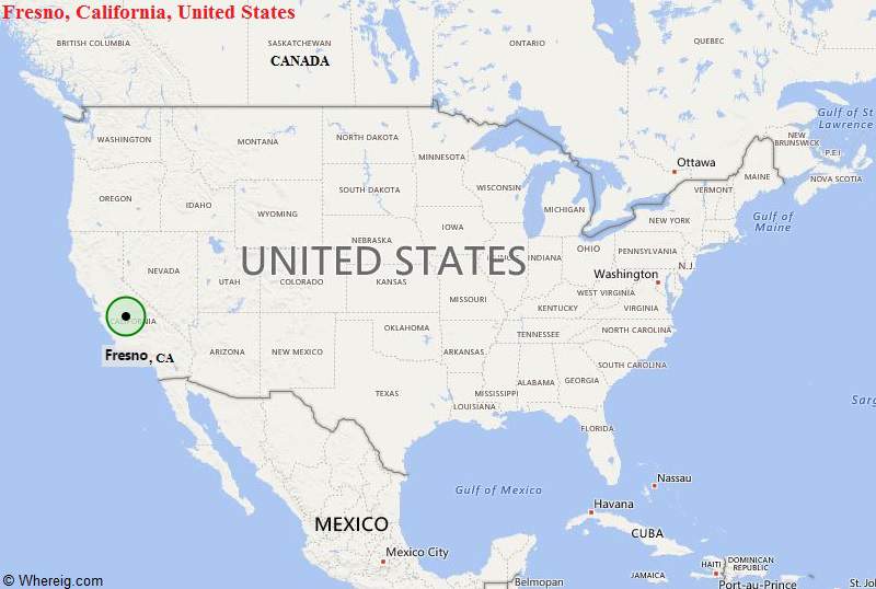
Fresno, California Quick Facts
| Fact | Details |
|---|---|
| City | Fresno |
| County | Fresno County |
| State | California |
| State Capital | Sacramento |
| US Region | West |
| Latitude | 36.7378° N |
| Longitude | 119.7871° W |
| Elevation | 308 ft (94 m) |
| Land Area | 115.2 sq mi |
| Water Area | 0.6 sq mi |
| Total Area | 115.8 sq mi |
| Population (2020 Census) | 542,107 |
| Population Density | Approximately 4,706 per sq mi |
| ZIP Codes | 93650, 93701, 93702, 93703, 93704, 93705, 93706, 93710, 93711, 93720, 93721, 93722, 93723, 93725, 93726, 93727, 93728, 93730, 93737 |
| Area Code | 559 |
| Time Zone Standard | Pacific Standard Time (PST, UTC-8) |
| Time Zone Daylight | Pacific Daylight Time (PDT, UTC-7) |
| Currency | US Dollar (USD) |
| FIPS Code | 06-27000 |
| Congressional District | California 21st Congressional District |
Location and Surroundings
Fresno is located in the heart of California's San Joaquin Valley in Fresno County. It lies between Sacramento to the north and Bakersfield to the south, with the Sierra Nevada Mountains rising to the east. The city is known for its agricultural economy, proximity to Yosemite and Sequoia National Parks, and its role as the largest city in California's Central Valley.
Nearby Cities to Fresno, California
- Clovis, California - 6 mi Northeast
- Kerman, California - 15 mi West
- Sanger, California - 13 mi East
- Madera, California - 22 mi Northwest
- Selma, California - 18 mi Southeast
- Reedley, California - 23 mi Southeast
- Kingsburg, California - 23 mi South
- Hanford, California - 32 mi Southwest
- Visalia, California - 43 mi Southeast
- Merced, California - 57 mi Northwest
Fresno, California Climate and Weather Overview
| Month | Avg High (°F) | Avg Low (°F) | Avg Rainfall (in) |
|---|---|---|---|
| January | 56 | 38 | 2.2 |
| April | 75 | 49 | 1.0 |
| July | 98 | 68 | 0.0 |
| October | 82 | 55 | 0.6 |
| Annual | 78 | 52 | 11.5 |
| Climate Attribute | Details |
|---|---|
| Climate Classification (Köppen) | Hot-Summer Mediterranean (Csa) |
| Annual Rainfall | About 11.5 inches |
| Annual Sunshine Days | Approximately 271 days |
| Hurricane/Tornado Risk | Very low |
| Snowfall | Rare |
Driving Distances from Fresno, California
| City | State | Distance (mi) | Approx. Drive Time |
|---|---|---|---|
| Clovis | California | 6 | 15 min |
| Sanger | California | 13 | 20 min |
| Kerman | California | 15 | 20 min |
| Madera | California | 22 | 25 min |
| Selma | California | 18 | 25 min |
| Reedley | California | 23 | 30 min |
| Hanford | California | 32 | 40 min |
| Visalia | California | 43 | 50 min |
| Merced | California | 57 | 1 hr |
| Bakersfield | California | 110 | 1 hr 45 min |
Transportation and Connectivity in Fresno, California
| Category | Details |
|---|---|
| Airport Name | Fresno Yosemite International Airport |
| IATA Code | FAT |
| Port | Not Applicable |
| Major Highways | CA 99, CA 41, CA 168, CA 180 |
| Train/Amtrak Service | Amtrak San Joaquins |
| Local Bus/Transit Service | Fresno Area Express (FAX) |
- State Route 99 - Main north-south transportation corridor through the Central Valley.
- State Route 41 - Connects Fresno with Yosemite National Park and the Central Coast.
- State Route 168 - Provides access to the Sierra Nevada foothills and mountain recreation areas.
- State Route 180 - Connects Fresno with Kings Canyon National Park and western valley communities.
- Shaw Avenue - Major east-west arterial through the city.
- Herndon Avenue - Important commercial corridor serving northern Fresno.
Key Landmarks and Places to Visit in Fresno, California
| Landmark Name | Type |
|---|---|
| Forestiere Underground Gardens | Historic Attraction |
| Fresno Chaffee Zoo | Zoo |
| Woodward Park | Regional Park |
| Fresno Art Museum | Museum |
| Shinzen Japanese Garden | Botanical Garden |
| Tower District | Entertainment District |
| Meux Home Museum | Historic House Museum |
| Island Waterpark | Water Park |
| Discovery Center | Science Museum |
| Kearney Mansion Museum | Historic Site |
Waterbodies in Fresno, California
San Joaquin River, Kings River, Millerton Lake, Pine Flat Lake, Friant-Kern Canal, Fresno Irrigation Canal, Dry Creek, Redbank Creek, Big Dry Creek Reservoir, Hensley Lake
Golf Courses in Fresno, California
Riverside Golf Course, Airways Golf Club, Copper River Country Club, Belmont Country Club, Fort Washington Country Club, Sunnyside Country Club, Dragonfly Golf Club, Eagle Springs Golf and Country Club, Ridge Creek Dinuba Golf Club, Madera Golf and Country Club
Economy and Major Employers in Fresno, California
| Sector | Major Employer or Industry | Notes |
|---|---|---|
| Agriculture | Farming and Food Processing | Foundation of the regional economy. |
| Healthcare | Community Health System | Major healthcare provider and employer. |
| Education | California State University, Fresno | Large educational institution. |
| Government | City and County Government | Significant public-sector employment. |
| Distribution | Warehousing and Logistics | Benefits from Central Valley location. |
| Retail | Commercial and Shopping Centers | Major employment source. |
| Manufacturing | Food and Industrial Manufacturing | Supports agricultural production. |
| Tourism | National Park Gateway Services | Serves visitors to nearby parks. |
Colleges and Schools in Fresno, California
| Institution Name | Type | Level | Notable For |
|---|---|---|---|
| California State University, Fresno | Public | University | Major Central Valley university |
| Fresno City College | Public | Community College | One of California's oldest community colleges |
| National University Fresno | Private | University | Adult and professional education |
| Fresno Pacific University | Private | University | Christian higher education |
| Fresno Unified School District | Public | K-12 District | One of California's largest school districts |
| Central Unified School District | Public | K-12 District | Serves western Fresno communities |
Fresno, California - Key Historical Facts
- Fresno was founded in 1872 as a station along the Central Pacific Railroad.
- The city's name comes from the Spanish word for ash tree, referring to the native trees along local waterways.
- Fresno became a major agricultural center due to irrigation projects that transformed the San Joaquin Valley.
- The development of raisin, grape, cotton, and fruit industries fueled rapid growth during the late nineteenth and twentieth centuries.
- California State University, Fresno, established in 1911, became an important educational and cultural institution for the region.
- Today, Fresno serves as the economic and cultural hub of California's Central Valley.
Sources
- Official City of Fresno Website
- Official Fresno County Website
- U.S. Census Bureau
- U.S. Geological Survey (USGS)
- National Weather Service
Most Viewed CA Maps
- Where is Los Angeles
- Where is San Diego
- Where is San Francisco
- Where is Anaheim
- Where is Bakersfield
- Where is Chula Vista
- Where is Freemont
- Where is Fresno
- Where is Glendale
- Where is Irvine
- Where is Long Beach
- Where is Modesto
- Where is Oakland
- Where is Paradise
- Where is Riverside
- Where is Sacramento
- Where is San Bernardino
- Where is San Jose
- Where is Santa Ana
- Where is Stockton
- Where is Berkeley
- Where is Clovis
- Where is Corona
- Where is Elk Grove
- Where is Escondido
- Where is Fontana
- Where is Fremont
- Where is Fullerton
- Where is Garden Grove
- Where is Hayward
- Where is Huntington Beach
- Where is Lancaster
- Where is Moreno Valley
- Where is Oceanside
- Where is Ontario
- Where is Orange
- Where is Oxnard
- Where is Palmdale
- Where is Pasadena
- Where is Pomona
- Where is Rancho Cucamonga
- Where is Roseville
- Where is Salinas
- Where is Santa Clara
- Where is Santa Clarita
- Where is Santa Rosa
- Where is Sunnyvale
- Where is Thousand Oaks
- Where is Torrance
- Where is Vallejo
- Where is Victorville
- Where is Visalia