
Where is Pomona Located? - Pomona is a city located in the Los Angeles County of California, United States. Pomona lies between 40.0992 Degrees North latitudes and 104.9372 Degrees West longitudes.
Location Map of Pomona, California
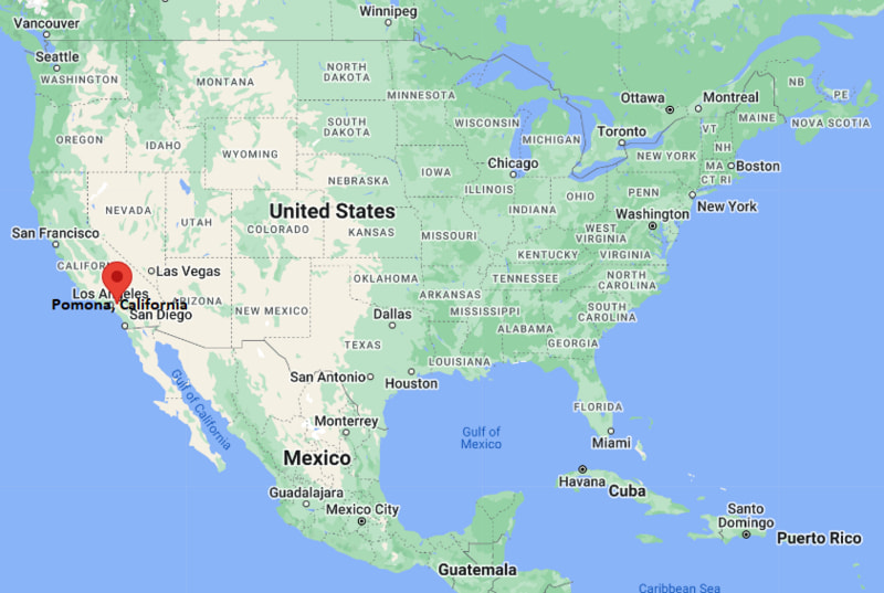
Pomona Map, California, USA
Where is Pomona?: The Google Map showing the location of Pomona in the U.S. state of California.
Where is Pomona Located?
Pomona is a city located in the Los Angeles County of California, United States. Pomona lies between 40.0992 Degrees North latitudes and 104.9372 Degrees West longitudes. According to 2020 U.S.census, the population of Pomona city is 151713 people and the city has a total area of 22.98 sq mi. The city has numerous parks and recreational facilities.
Most Viewed US Maps
| USA Sttae Map | USA Region Map | USA Road Map |
| USA County Map | Where is USA in World Map? | US ZIP Code Map |
| USA Time Zones Map | US State and Capitals Map | USA Physical Map |
Find 4,400+ U.S. Cities by State - Explore Their Locations and Get Detailed Information
Pomona, California Quick Facts
| Attribute | Details |
|---|---|
| City | Pomona |
| County | Los Angeles County |
| State | California |
| State Capital | Sacramento |
| US Region | Western United States (Pacific Region) |
| Latitude | 34.0551° N |
| Longitude | 117.7500° W |
| Elevation | 850 ft (259 m) |
| Land Area | 22.96 sq mi |
| Water Area | 0.00 sq mi |
| Total Area | 22.96 sq mi |
| Population (2020 Census) | 151,713 |
| Population Density | Approximately 6,607 people per sq mi |
| ZIP Codes | 91766, 91767, 91768 |
| Area Code | 909 |
| Time Zone Standard | Pacific Standard Time (PST, UTC−8) |
| Time Zone Daylight | Pacific Daylight Time (PDT, UTC−7) |
| Currency | United States Dollar (USD) |
| FIPS Code | 06-58072 |
| Congressional District | California's 35th Congressional District |
Transportation and Connectivity in Pomona
| Category | Details |
|---|---|
| Airport Name | Ontario International Airport |
| IATA Code | ONT |
| Port | Port of Los Angeles and Port of Long Beach (regional access) |
| Major Highways | Interstate 10, State Route 57, State Route 71, State Route 60 |
| Train/Amtrak Service | Metrolink and Amtrak service at Pomona stations |
| Local Bus/Transit Service | Foothill Transit and Los Angeles County Metro services |
- Interstate 10 – Major east–west freeway connecting Pomona with Los Angeles, San Bernardino, and communities across Southern California.
- State Route 57 – Important north–south freeway linking Pomona with Orange County and the Inland Empire.
- State Route 71 – Regional freeway connecting Pomona with Chino Hills and the surrounding area.
- State Route 60 – Major east–west route serving the San Gabriel Valley and Inland Empire.
Top Places to Visit in Pomona, California
| Landmark Name | Type |
|---|---|
| Fairplex | Event and Exhibition Center |
| Los Angeles County Fair | Annual Event |
| Wally Parks NHRA Motorsports Museum | Automotive Museum |
| American Museum of Ceramic Art | Art Museum |
| Pomona College Museum of Art | Art Museum |
| Phillips Mansion | Historic Landmark |
| Ganesha Park | Community Park |
| Frank G. Bonelli Regional Park | Regional Park |
| California State Polytechnic University, Pomona | University Campus |
| Palomares Adobe | Historic Site |
Driving Distances from Pomona, California to Nearby Cities
| City | State | Distance (mi) | Approx. Drive Time |
|---|---|---|---|
| Claremont | California | 6 | 10 minutes |
| Ontario | California | 10 | 15 minutes |
| Diamond Bar | California | 8 | 15 minutes |
| West Covina | California | 10 | 20 minutes |
| Pasadena | California | 25 | 35 minutes |
| Los Angeles | California | 30 | 45 minutes |
| Riverside | California | 35 | 45 minutes |
| Anaheim | California | 35 | 45 minutes |
| Santa Ana | California | 45 | 1 hour |
| San Diego | California | 125 | 2 hours |
Colleges and Universities in Pomona, California
| Institution Name | Type | Level | Notable For |
|---|---|---|---|
| California State Polytechnic University, Pomona | Public | University | Engineering, agriculture, business, architecture, and applied sciences |
| Pomona College | Private | Liberal Arts College | Liberal arts education and undergraduate research |
| Western University of Health Sciences | Private | University | Health sciences, medicine, and healthcare education |
| Claremont Colleges | Private | Higher Education Consortium | Liberal arts, science, and research programs |
| Mt. San Antonio College | Public | Community College | Career training and transfer education |
| Pomona Unified School District | Public | K–12 District | Primary and secondary education |
Waterbodies in Pomona, California
San Gabriel River watershed, Walnut Creek, San Jose Creek, Coyote Creek, and nearby reservoirs including Puddingstone Lake at Frank G. Bonelli Regional Park.
Golf Courses in Pomona
Mountain Meadows Golf Course, San Dimas Canyon Golf Course, Los Serranos Country Club, Whispering Lakes Golf Course, and Marshall Canyon Golf Course.
Pomona, California — Key Historical Facts
- Pomona was founded in the late nineteenth century and was named after Pomona, the Roman goddess of fruit and gardens.
- The city developed as an agricultural community known for citrus orchards, vineyards, and fertile farmland in the Pomona Valley.
- The arrival of railroads helped Pomona grow as a regional center for trade, agriculture, and transportation.
- The Los Angeles County Fair, first held in Pomona in 1922, became one of the city's most recognized annual events.
- Today, Pomona is known for its universities, cultural attractions, historic districts, Fairplex events, and location within the greater Los Angeles metropolitan area.
References
- City of Pomona
- Los Angeles County Government
- U.S. Census Bureau
- Visit California
- California Office of Historic Preservation
California Related Links
- Where is Los Angeles
- Where is San Diego
- Where is San Francisco
- Where is Anaheim
- Where is Bakersfield
- Where is Chula Vista
- Where is Freemont
- Where is Fresno
- Where is Glendale
- Where is Irvine
- Where is Long Beach
- Where is Modesto
- Where is Oakland
- Where is Paradise
- Where is Riverside
- Where is Sacramento
- Where is San Bernardino
- Where is San Jose
- Where is Santa Ana
- Where is Stockton
- Where is Berkeley
- Where is Clovis
- Where is Corona
- Where is Elk Grove
- Where is Escondido
- Where is Fontana
- Where is Fremont
- Where is Fullerton
- Where is Garden Grove
- Where is Hayward
- Where is Huntington Beach
- Where is Lancaster
- Where is Moreno Valley
- Where is Oceanside
- Where is Ontario
- Where is Orange
- Where is Oxnard
- Where is Palmdale
- Where is Pasadena
- Where is Pomona
- Where is Rancho Cucamonga
- Where is Roseville
- Where is Salinas
- Where is Santa Clara
- Where is Santa Clarita
- Where is Santa Rosa
- Where is Sunnyvale
- Where is Thousand Oaks
- Where is Torrance
- Where is Vallejo
- Where is Victorville
- Where is Visalia