
Where is Visalia Located? - Visalia is a city located in the Tulare County of California, United States. Visalia lies between 39.8418 Degrees North latitudes and 104.9591 Degrees West longitudes.
Location Map of Visalia, California
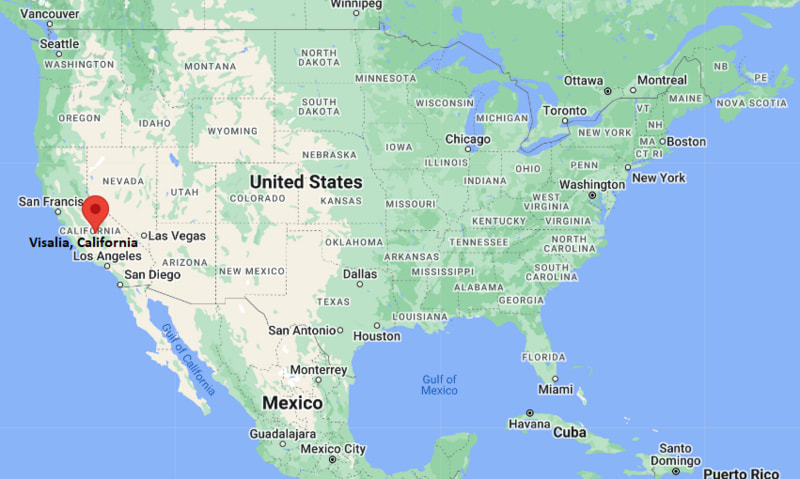
Visalia Map, California, USA
Where is Visalia?: The Google Map showing the location of Visalia in the U.S. state of California.
Where is Visalia Located?
Visalia is a city located in the Tulare County of California, United States. Visalia lies between 39.8418 Degrees North latitudes and 104.9591 Degrees West longitudes. According to 2020 U.S.census, the population of Visalia city is 141384 people and the city has a total area of 37.92 sq mi. The city has numerous parks and recreational facilities.
Most Viewed US Maps
| USA Sttae Map | USA Region Map | USA Road Map |
| USA County Map | Where is USA in World Map? | US ZIP Code Map |
| USA Time Zones Map | US State and Capitals Map | USA Physical Map |
Find 4,400+ U.S. Cities by State - Explore Their Locations and Get Detailed Information
Visalia, California Quick Facts
| Attribute | Details |
|---|---|
| City | Visalia |
| County | Tulare County |
| State | California |
| State Capital | Sacramento |
| US Region | Western United States |
| Latitude | 36.3302° N |
| Longitude | 119.2921° W |
| Elevation | Approximately 331 ft (101 m) |
| Land Area | 37.3 sq mi |
| Water Area | 0.0 sq mi |
| Total Area | 37.3 sq mi |
| Population (2020 Census) | 141,384 |
| Population Density | Approximately 3,790 per sq mi |
| ZIP Codes | 93277, 93278, 93279, 93290, 93291, 93292 |
| Area Code | 559 |
| Time Zone Standard | Pacific Standard Time (PST), UTC−8 |
| Time Zone Daylight | Pacific Daylight Time (PDT), UTC−7 |
| Currency | United States Dollar (USD) |
| FIPS Code | 06-82954 |
| Community Type | City |
Transportation and Connectivity in Visalia, California
| Transportation | Details |
|---|---|
| Airport Name | Visalia Municipal Airport |
| IATA Code | VIS |
| Regional Airport | Fresno Yosemite International Airport |
| Port | Port of Stockton and Port of Oakland connections |
| Major Highways | State Route 99, State Route 198, State Route 63 |
| Train/Amtrak Service | Amtrak service available through nearby Hanford station |
| Local Transit Service | Visalia Transit public transportation |
- State Route 99 — Major north-south highway connecting Visalia with Fresno, Bakersfield, and Sacramento.
- State Route 198 — East-west highway connecting Visalia with Sequoia National Park and the Central Valley.
- State Route 63 — Local route providing access throughout Tulare County.
Top Places to Visit in Visalia, California
| Landmark Name | Type |
|---|---|
| Sequoia National Park | National Park |
| Kaweah Oaks Preserve | Nature Preserve |
| Mooney Grove Park | Historic Park |
| ImagineU Children's Museum | Children's Museum |
| Tulare County Museum | History Museum |
| Visalia Fox Theatre | Historic Theater |
| Visalia Adventure Park | Entertainment Center |
| Riverway Sports Park | Recreation Complex |
| Exeter Murals | Public Art Attraction |
| Sequoia National Forest | National Forest |
Driving Distances from Visalia, California to Nearby Cities
| City | State | Distance (mi) | Approx. Drive Time |
|---|---|---|---|
| Tulare | California | 10 mi | 15 minutes |
| Fresno | California | 45 mi | 50 minutes |
| Bakersfield | California | 85 mi | 1 hour 30 minutes |
| Sequoia National Park | California | 45 mi | 1 hour 15 minutes |
| Los Angeles | California | 200 mi | 3 hours 15 minutes |
| San Francisco | California | 220 mi | 3 hours 45 minutes |
| Sacramento | California | 235 mi | 3 hours 45 minutes |
| San Jose | California | 230 mi | 3 hours 45 minutes |
| Las Vegas | Nevada | 300 mi | 4 hours 45 minutes |
| San Diego | California | 310 mi | 5 hours |
Colleges and Universities Near Visalia, California
| Institution Name | Type | Level | Notable For |
|---|---|---|---|
| College of the Sequoias | Public | Community College | Transfer programs, nursing, agriculture, and career education |
| California State University, Fresno | Public | University | Agriculture, business, education, engineering, and research |
| Fresno Pacific University | Private | University | Education, business, arts, and professional studies |
| University of California, Merced | Public | University | Research, science, engineering, and humanities |
| Visalia Unified School District | Public | K–12 District | Local public education |
Waterbodies Near Visalia, California
Kaweah River, Lake Kaweah, St. Johns River, Mill Creek, and nearby Tulare County waterways
Golf Courses and Stadiums Near Visalia
Golf Courses: Valley Oaks Golf Course, Ridge Creek Dinuba Golf Club, and nearby Central Valley golf facilities. Stadiums: Valley Strong Ballpark, College of the Sequoias athletic facilities, and local community sports fields.
Key Landmarks and Places to Visit in Visalia, California
| Landmark Name | Type |
|---|---|
| Sequoia National Park | National Park |
| Sequoia National Forest | National Forest |
| Kaweah Oaks Preserve | Nature Preserve |
| Mooney Grove Park | Historic Park |
| Tulare County Museum | History Museum |
| Visalia Fox Theatre | Historic Theater |
| ImagineU Children's Museum | Children's Museum |
| Riverway Sports Park | Recreation Complex |
| Lake Kaweah | Recreation Area |
| Visalia Convention Center | Event Venue |
Visalia, California — Key Historical Facts
- The Visalia area was originally inhabited by Native American groups, including the Yokuts people who lived throughout the southern San Joaquin Valley.
- Visalia was founded in 1852 and named after Visalia, Kentucky, the hometown of early settler Nathaniel Vise.
- The city developed as an agricultural center because of its fertile soils, irrigation systems, and location in the Central Valley.
- Visalia became the county seat of Tulare County in 1853 and grew as a regional center for farming, trade, and government services.
- The arrival of the railroad in the late 19th century helped expand Visalia's economy and connections with other California communities.
- Today, Visalia is known for agriculture, outdoor recreation, its location near Sequoia National Park, historic downtown, and Central Valley culture.
References
- United States Census Bureau
- City of Visalia Official Website
- Tulare County Official Website
- State of California Official Website
- Visit California Tourism
California Related Links
- Where is Los Angeles
- Where is San Diego
- Where is San Francisco
- Where is Anaheim
- Where is Bakersfield
- Where is Chula Vista
- Where is Freemont
- Where is Fresno
- Where is Glendale
- Where is Irvine
- Where is Long Beach
- Where is Modesto
- Where is Oakland
- Where is Paradise
- Where is Riverside
- Where is Sacramento
- Where is San Bernardino
- Where is San Jose
- Where is Santa Ana
- Where is Stockton
- Where is Berkeley
- Where is Clovis
- Where is Corona
- Where is Elk Grove
- Where is Escondido
- Where is Fontana
- Where is Fremont
- Where is Fullerton
- Where is Garden Grove
- Where is Hayward
- Where is Huntington Beach
- Where is Lancaster
- Where is Moreno Valley
- Where is Oceanside
- Where is Ontario
- Where is Orange
- Where is Oxnard
- Where is Palmdale
- Where is Pasadena
- Where is Pomona
- Where is Rancho Cucamonga
- Where is Roseville
- Where is Salinas
- Where is Santa Clara
- Where is Santa Clarita
- Where is Santa Rosa
- Where is Sunnyvale
- Where is Thousand Oaks
- Where is Torrance
- Where is Vallejo
- Where is Victorville
- Where is Visalia