
Where is Thousand Oaks Located? - Thousand Oaks is a city located in the Ventura County of California, United States. Thousand Oaks lies between 41.3948 Degrees North latitudes and 73.4540 Degrees West longitudes.
Location Map of Thousand Oaks, California
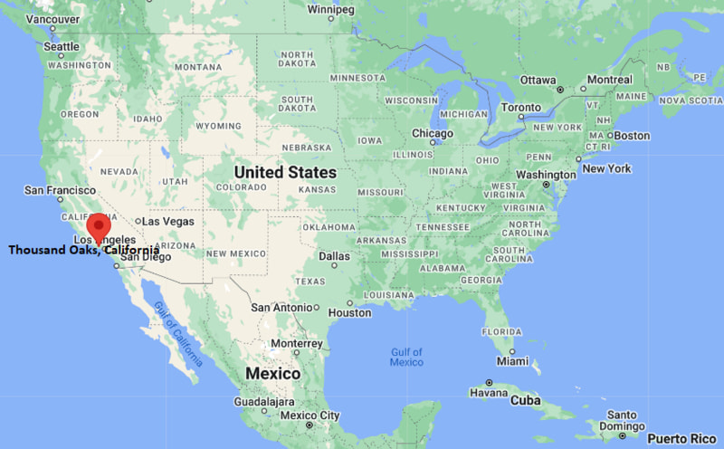
Thousand Oaks Map, California, USA
Where is Thousand Oaks?: The Google Map showing the location of Thousand Oaks in the U.S. state of California.
Where is Thousand Oaks Located?
Thousand Oaks is a city located in the Ventura County of California, United States. Thousand Oaks lies between 41.3948 Degrees North latitudes and 73.4540 Degrees West longitudes. According to 2020 U.S.census, the population of Thousand Oaks city is 126966 people and the city has a total area of 55.26 sq mi. The city has numerous parks and recreational facilities.
Most Viewed US Maps
| USA Sttae Map | USA Region Map | USA Road Map |
| USA County Map | Where is USA in World Map? | US ZIP Code Map |
| USA Time Zones Map | US State and Capitals Map | USA Physical Map |
Find 4,400+ U.S. Cities by State - Explore Their Locations and Get Detailed Information
Thousand Oaks, California Quick Facts
| Attribute | Details |
|---|---|
| City | Thousand Oaks |
| County | Ventura County |
| State | California |
| State Capital | Sacramento |
| US Region | Western United States |
| Latitude | 34.1706° N |
| Longitude | 118.8376° W |
| Elevation | Approximately 886 ft (270 m) |
| Land Area | 55.2 sq mi |
| Water Area | 0.0 sq mi |
| Total Area | 55.2 sq mi |
| Population (2020 Census) | 126,966 |
| Population Density | Approximately 2,300 per sq mi |
| ZIP Codes | 91319, 91320, 91358, 91360, 91361, 91362 |
| Area Code | 805 |
| Time Zone Standard | Pacific Standard Time (PST), UTC−8 |
| Time Zone Daylight | Pacific Daylight Time (PDT), UTC−7 |
| Currency | United States Dollar (USD) |
| FIPS Code | 06-78582 |
| Congressional District | California's 26th Congressional District |
Transportation and Connectivity in Thousand Oaks, California
| Transportation | Details |
|---|---|
| Airport Name | Los Angeles International Airport |
| IATA Code | LAX |
| Regional Airport | Hollywood Burbank Airport |
| Port | Port of Los Angeles and Port of Long Beach |
| Major Highways | US Highway 101, State Route 23 |
| Train/Amtrak Service | Amtrak service available in nearby Moorpark and Ventura |
| Local Transit Service | Thousand Oaks Transit and regional bus services |
- US Highway 101 — Main highway connecting Thousand Oaks with Los Angeles, Ventura, and coastal communities.
- State Route 23 — Provides access between Thousand Oaks, the San Fernando Valley, and inland areas.
Top Places to Visit in Thousand Oaks, California
| Landmark Name | Type |
|---|---|
| Santa Monica Mountains National Recreation Area | Natural Recreation Area |
| Stagecoach Inn Museum | History Museum |
| Gardens of the World | Botanical Garden |
| Conejo Valley Botanic Garden | Garden Attraction |
| Wildwood Regional Park | Regional Park |
| Paradise Falls | Waterfall and Hiking Area |
| Thousand Oaks Civic Arts Plaza | Performing Arts Center |
| The Oaks Mall | Shopping Center |
| Chumash Indian Museum | Cultural Museum |
| Los Robles Greens | Golf and Recreation Facility |
Driving Distances from Thousand Oaks, California to Nearby Cities
| City | State | Distance (mi) | Approx. Drive Time |
|---|---|---|---|
| Ventura | California | 25 mi | 35 minutes |
| Los Angeles | California | 40 mi | 50 minutes |
| Santa Barbara | California | 70 mi | 1 hour 15 minutes |
| Santa Monica | California | 35 mi | 45 minutes |
| Malibu | California | 25 mi | 35 minutes |
| Burbank | California | 35 mi | 45 minutes |
| Pasadena | California | 55 mi | 1 hour |
| San Diego | California | 150 mi | 2 hours 30 minutes |
| Fresno | California | 190 mi | 3 hours 15 minutes |
| San Francisco | California | 360 mi | 5 hours 30 minutes |
Colleges and Universities Near Thousand Oaks, California
| Institution Name | Type | Level | Notable For |
|---|---|---|---|
| California Lutheran University | Private | University | Liberal arts, business, education, and professional programs |
| Moorpark College | Public | Community College | Transfer programs, career training, and technical education |
| Ventura College | Public | Community College | Associate degrees and workforce programs |
| Pepperdine University | Private | University | Law, business, liberal arts, and graduate programs |
| Conejo Valley Unified School District | Public | K–12 District | Local public education |
Waterbodies Near Thousand Oaks, California
Lake Sherwood, Westlake Lake, Malibu Creek, Arroyo Conejo, Pacific Ocean
Golf Courses and Stadiums Near Thousand Oaks
Golf Courses: Los Robles Greens, North Ranch Country Club, Sunset Hills Country Club, Sherwood Country Club. Stadiums: William Rolland Stadium, Cal Lutheran University athletic facilities, and nearby SoFi Stadium.
Key Landmarks and Places to Visit in Thousand Oaks, California
| Landmark Name | Type |
|---|---|
| Santa Monica Mountains National Recreation Area | Natural Landmark |
| Wildwood Regional Park | Regional Park |
| Stagecoach Inn Museum | History Museum |
| Gardens of the World | Botanical Garden |
| Thousand Oaks Civic Arts Plaza | Performing Arts Center |
| Chumash Indian Museum | Cultural Museum |
| Paradise Falls | Natural Attraction |
| Conejo Valley Botanic Garden | Garden Attraction |
Thousand Oaks, California — Key Historical Facts
- Thousand Oaks was named after the many oak trees that cover the Conejo Valley region.
- The area has a long history connected to the Chumash people, who lived throughout the region for thousands of years.
- European settlement expanded in the 19th century with ranching and agricultural development.
- The city was incorporated in 1964 and became one of the largest planned communities in Ventura County.
- Today, Thousand Oaks is known for its open spaces, oak woodlands, cultural attractions, biotechnology industry, and access to the Santa Monica Mountains.
References
- United States Census Bureau
- City of Thousand Oaks Official Website
- Ventura County Official Website
- State of California Official Website
- Visit California Tourism
California Related Links
- Where is Los Angeles
- Where is San Diego
- Where is San Francisco
- Where is Anaheim
- Where is Bakersfield
- Where is Chula Vista
- Where is Freemont
- Where is Fresno
- Where is Glendale
- Where is Irvine
- Where is Long Beach
- Where is Modesto
- Where is Oakland
- Where is Paradise
- Where is Riverside
- Where is Sacramento
- Where is San Bernardino
- Where is San Jose
- Where is Santa Ana
- Where is Stockton
- Where is Berkeley
- Where is Clovis
- Where is Corona
- Where is Elk Grove
- Where is Escondido
- Where is Fontana
- Where is Fremont
- Where is Fullerton
- Where is Garden Grove
- Where is Hayward
- Where is Huntington Beach
- Where is Lancaster
- Where is Moreno Valley
- Where is Oceanside
- Where is Ontario
- Where is Orange
- Where is Oxnard
- Where is Palmdale
- Where is Pasadena
- Where is Pomona
- Where is Rancho Cucamonga
- Where is Roseville
- Where is Salinas
- Where is Santa Clara
- Where is Santa Clarita
- Where is Santa Rosa
- Where is Sunnyvale
- Where is Thousand Oaks
- Where is Torrance
- Where is Vallejo
- Where is Victorville
- Where is Visalia