Written and fact-checked by Whereig.com Web Team | Last Updated: December 16, 2025, 14:30 ET
Map of Ventura County - Ventura County is a county located in the U.S. state of California. Ventura County Map showing cities, highways, important places and water bodies. Get Where is Ventura County located in the map, major cities in Ventura county, population, areas, and places of interest.
Ventura County Map, California
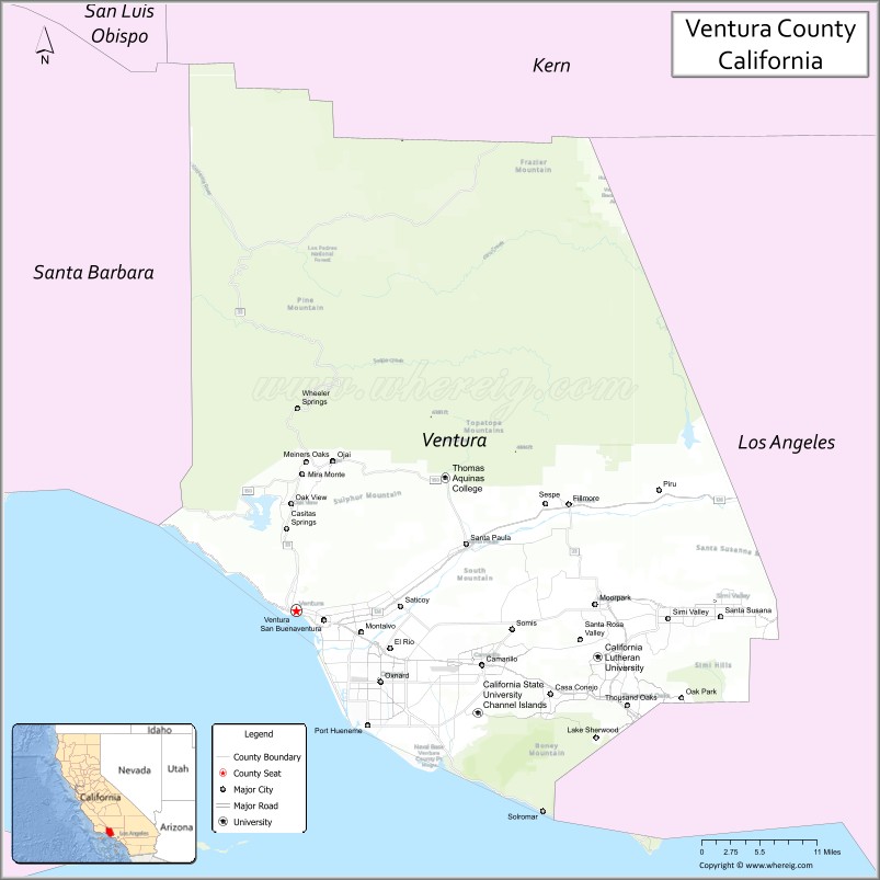
About Ventura County Map, California: The map showing the county boundary, county seat, major cities, highways, water bodies and neighbouring counties.
Most Viewed Links
About Ventura County, California
Ventura County is a county located in the southern part of the state of California, United States. The county seat and largest city is Ventura. According to the United States Census Bureau, the county has a total area of 2,208 square miles (5,722 km²), of which 1,843 square miles (4,774 km²) is land and 365 square miles (948 km²) (16.5%) is water.
As of the 2020 United States Census, the population of Ventura County was 846,006. Ventura County was established on 1872. The county is known for its beautiful beaches, including Ventura Beach, Surfer's Point, and Silver Strand Beach. The area is also known for its agriculture, with crops such as strawberries, lemons, and avocados being among the top products grown in the area.
Major cities and towns in Ventura County include Ventura, Oxnard, and Thousand Oaks. The county is bordered by Santa Barbara County to the north, Kern County to the northeast, Los Angeles County to the east and southeast, and the Pacific Ocean to the west. The western part of the county is home to Channel Islands National Park, a popular destination for hiking, kayaking, and whale watching.
Facts about Tuolumne County, California
| Country | United States |
| State | California |
| Region | Sierra Nevada foothills & mountains |
| County Seat | Sonora |
| Named After | Tuolumne River (name of Native American origin) |
| Established | 1850 |
| Organized | 1850 |
| Coordinates | 37.9810° N, 120.2636° W |
| Total Area | 2,274 sq mi |
| Land Area | 2,221 sq mi |
| Water Area | 53 sq mi |
| Population (2020) | 54,478 |
| Population Rank | Small-to-mid-sized county in California |
| Major Communities | Sonora, Twain Harte, Groveland |
| Main Industries | Tourism, Government Services, Healthcare, Outdoor Recreation |
| Major Airport | Columbia Airport |
| Time Zone | Pacific Time (UTC−08:00) |
| Known For | Gold Rush history, Yosemite National Park (part), Sierra Nevada scenery |
| Website | https://www.tuolumnecounty.ca.gov |
Ctities in Ventura county County
| City Name | Type | Population (2020) | Pop. Density | Area | Incorporated |
|---|---|---|---|---|---|
| Camarillo | City | 70,741 | 3,592.7/sq mi (1,387.2/km2) | 19.69 sq mi (51 km2) | March 28, 1964 |
| Fillmore | City | 16,419 | 4,975.5/sq mi (1,921.0/km2) | 3.3 sq mi (8.5 km2) | July 10, 1914 |
| Moorpark | City | 36,284 | 2,954.7/sq mi (1,140.8/km2) | 12.28 sq mi (31.8 km2) | July 1, 1983 |
| Ojai | City | 7,637 | 1,751.6/sq mi (676.3/km2) | 4.36 sq mi (11.3 km2) | August 5, 1921 |
| Oxnard | City | 202,063 | 7,616.4/sq mi (2,940.7/km2) | 26.53 sq mi (68.7 km2) | June 30, 1903 |
| Port Hueneme | City | 21,954 | 4,967.0/sq mi (1,917.8/km2) | 4.42 sq mi (11.4 km2) | March 24, 1948 |
| Santa Paula | City | 30,657 | 5,543.8/sq mi (2,140.5/km2) | 5.53 sq mi (14.3 km2) | April 22, 1902 |
| Simi Valley | City | 126,356 | 3,041.1/sq mi (1,174.2/km2) | 41.55 sq mi (107.6 km2) | October 10, 1969 |
| Thousand Oaks | City | 126,966 | 2,297.6/sq mi (887.1/km2) | 55.26 sq mi (143.1 km2) | October 7, 1964 |
| Ventura | City | 110,763 | 5,060.0/sq mi (1,953.7/km2) | 21.89 sq mi (56.7 km2) | April 2, 1866 |
Places to Visit in Ventura County
Top places to visit in Ventura includes Mission Basilica San, Ventura Botanical Gardens, Surfers Point at Seaside Park, Marina Park, San Buenaventura.
Highways in Ventura County
U.S. Route 101, State Route 1, State Route 23, State Route 33, State Route 34, State Route 11, State Route 126, State Route 150, State Route 232, State Route 257.
Nearest Airports
Nearest airport of Ventura is Oxnard Airport, Camarillo Airport.
- Alameda County Map
- Alpine County Map
- Amador County Map
- Butte County Map
- Calaveras County Map
- Colusa County Map
- Contra Costa County Map
- Del Norte County Map
- El Dorado County Map
- Fresno County Map
- Glenn County Map
- Humboldt County Map
- Imperial County Map
- Inyo County Map
- Kern County Map
- Kings County Map
- Lake County Map
- Lassen County Map
- Los Angeles County Map
- Madera County Map
- Marin County Map
- Mariposa County Map
- Mendocino County Map
- Merced County Map
- Modoc County Map
- Mono County Map
- Monterey County Map
- Napa County Map
- Nevada County Map
- Orange County Map
- Placer County Map
- Plumas County Map
- Riverside County Map
- Sacramento County Map
- San Benito County Map
- San Bernardino County Map
- San Diego County Map
- San Francisco County Map
- San Joaquin County Map
- San Luis Obispo County Map
- San Mateo County Map
- Santa Barbara County Map
- Santa Clara County Map
- Santa Cruz County Map
- Shasta County Map
- Sierra County Map
- Siskiyou County Map
- Solano County Map
- Sonoma County Map
- Stanislaus County Map
- Sutter County Map
- Tehama County Map
- Trinity County Map
- Tulare County Map
- Tuolumne County Map
- Ventura County Map
- Yolo County Map
- Yuba County Map
- Alabama Counties
- Alaska boroughs
- Arizona Counties
- Arkansas Counties
- California County Map
- Colorado Counties
- Connecticut Counties
- Delaware Counties
- Florida County Map
- Georgia County Map
- Hawaii Counties
- Idaho Counties
- Illinois Counties
- Indiana Counties
- Iowa Counties
- Kansas Counties
- Kentucky Counties
- Louisiana Counties
- Maine Counties
- Maryland Counties
- Massachusetts Counties
- Michigan County Map
- Minnesota Counties
- Mississippi Counties
- Missouri Counties
- Montana Counties
- Nebraska Counties
- Nevada Counties
- New York Counties
- New Hampshire Counties
- New Jersey Counties
- New Mexico Counties
- North Carolina Counties
- North Dakota Counties
- Ohio County Map
- Oklahoma Counties
- Oregon Counties
- Pennsylvania Counties
- Rhode Island Counties
- South Carolina Counties
- South Dakota Counties
- Map of Tennessee
- Texas County Map
- Utah Counties
- Vermont Counties
- Virginia Counties
- Washington Counties
- West Virginia Counties
- Wisconsin Counties
- Wyoming Counties