Written and fact-checked by Whereig.com Web Team | Last Updated: December 16, 2025, 14:30 ET
Map of Calaveras County - Calaveras County is a county located in the U.S. state of California. Calaveras County Map showing cities, highways, important places and water bodies. Get Where is Calaveras County located in the map, major cities in Calaveras county, population, areas, and places of interest.
Calaveras County Map, California
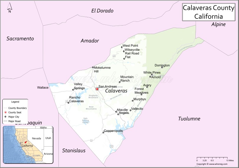
About Calaveras County Map, California: The map showing the county boundary, county seat, major cities, highways, water bodies and neighbouring counties.
Most Viewed Links
About Calaveras County, California
Calaveras County is a county located in the U.S. state of California. It's county seat is San Andreas. As per 2020 census, the population of Calaveras County is 46221 people and population density is square miles. According to the United States Census Bureau, the county has a total area of 1,020 sq mi (2,642 km2). Calaveras County was established on 1850.
The county seat and largest city in Calaveras County is San Andreas. Other notable communities in the county include Angels Camp, Copperopolis, Murphys, and Valley Springs.
Calaveras County is known for its natural beauty, including rolling hills, scenic vistas, and numerous lakes and rivers. Outdoor recreational opportunities in the area include hiking, camping, boating, fishing, and skiing. The county is also home to several historic sites, including the Calaveras Big Trees State Park, which features some of the largest trees in the world.
The economy of Calaveras County is primarily based on agriculture, tourism, and mining. The county is known for its wine industry, with several wineries located in the area. The county also has a significant gold mining history and is home to the Angels Camp Museum and Carriage House, which features exhibits on the county's mining past.
Facts about Calaveras County, California
| Country | United States |
| State | California |
| Region | Sierra Nevada foothills |
| County Seat | San Andreas |
| Named After | Spanish word “Calaveras,” meaning “skulls” |
| Established | 1850 |
| Organized | 1850 |
| Coordinates | 38.2050° N, 120.5540° W |
| Total Area | 1,037 sq mi |
| Land Area | 1,020 sq mi |
| Water Area | 17 sq mi |
| Population (2020) | 45,292 |
| Population Rank | Small-to-mid-sized county in California |
| Major Cities | San Andreas, Angels Camp, Vallecito |
| Main Industries | Tourism, Wine Production, Agriculture, Government Services |
| Major Airport | None (nearest commercial airports outside the county) |
| Time Zone | Pacific Time (UTC−08:00) |
| Known For | Calaveras Big Trees State Park, Jumping Frog Jubilee, Gold Rush history |
| Website | https://www.calaverasgov.us |
Ctities and Towns in Calaveras County
| City Name | Type | Population (2020) | Pop. Density | Area | Incorporated |
|---|---|---|---|---|---|
| Angels Camp | City | 3,667 | 1,010.2/sq mi (390.0/km2) | 3.63 sq mi (9.4 km2) | January 16, 1912 |
Places to Visit in Calaveras County
Top places to visit in Calaveras includes Moaning Caverns Adventure Park.
Highways in Calaveras County
State Route 4, State Route 12, State Route 26, State Route 49.
Nearest Airports
Nearest airport of Calaveras is Calaveras County Airport / Maury Rasmussen Field.
- Alameda County Map
- Alpine County Map
- Amador County Map
- Butte County Map
- Calaveras County Map
- Colusa County Map
- Contra Costa County Map
- Del Norte County Map
- El Dorado County Map
- Fresno County Map
- Glenn County Map
- Humboldt County Map
- Imperial County Map
- Inyo County Map
- Kern County Map
- Kings County Map
- Lake County Map
- Lassen County Map
- Los Angeles County Map
- Madera County Map
- Marin County Map
- Mariposa County Map
- Mendocino County Map
- Merced County Map
- Modoc County Map
- Mono County Map
- Monterey County Map
- Napa County Map
- Nevada County Map
- Orange County Map
- Placer County Map
- Plumas County Map
- Riverside County Map
- Sacramento County Map
- San Benito County Map
- San Bernardino County Map
- San Diego County Map
- San Francisco County Map
- San Joaquin County Map
- San Luis Obispo County Map
- San Mateo County Map
- Santa Barbara County Map
- Santa Clara County Map
- Santa Cruz County Map
- Shasta County Map
- Sierra County Map
- Siskiyou County Map
- Solano County Map
- Sonoma County Map
- Stanislaus County Map
- Sutter County Map
- Tehama County Map
- Trinity County Map
- Tulare County Map
- Tuolumne County Map
- Ventura County Map
- Yolo County Map
- Yuba County Map
- Alabama Counties
- Alaska boroughs
- Arizona Counties
- Arkansas Counties
- California County Map
- Colorado Counties
- Connecticut Counties
- Delaware Counties
- Florida County Map
- Georgia County Map
- Hawaii Counties
- Idaho Counties
- Illinois Counties
- Indiana Counties
- Iowa Counties
- Kansas Counties
- Kentucky Counties
- Louisiana Counties
- Maine Counties
- Maryland Counties
- Massachusetts Counties
- Michigan County Map
- Minnesota Counties
- Mississippi Counties
- Missouri Counties
- Montana Counties
- Nebraska Counties
- Nevada Counties
- New York Counties
- New Hampshire Counties
- New Jersey Counties
- New Mexico Counties
- North Carolina Counties
- North Dakota Counties
- Ohio County Map
- Oklahoma Counties
- Oregon Counties
- Pennsylvania Counties
- Rhode Island Counties
- South Carolina Counties
- South Dakota Counties
- Map of Tennessee
- Texas County Map
- Utah Counties
- Vermont Counties
- Virginia Counties
- Washington Counties
- West Virginia Counties
- Wisconsin Counties
- Wyoming Counties