Written and fact-checked by Whereig.com Web Team | Last Updated: December 16, 2025, 14:30 ET
Map of San Mateo County - San Mateo County is a county located in the U.S. state of California. San Mateo County Map showing cities, highways, important places and water bodies. Get Where is San Mateo County located in the map, major cities in San Mateo county, population, areas, and places of interest.
San Mateo County Map, California
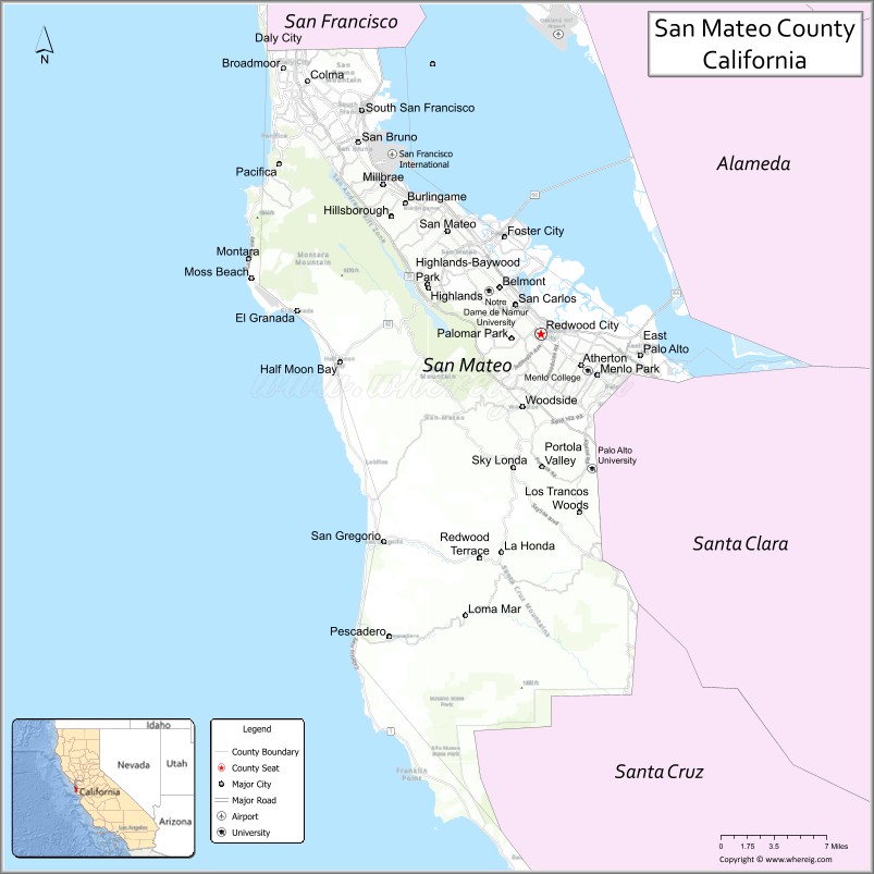
About San Mateo County Map, California: The map showing the county boundary, county seat, major cities, highways, water bodies and neighbouring counties.
Most Viewed Links
About San Mateo County, California
San Mateo County is a county located in the San Francisco Bay Area of California, with its county seat in the city of Redwood City. The county has an estimated population of over 770,000 people as of 2021.According to the United States Census Bureau, the county has a total area of 449 sq mi (1,163 km2). San Mateo County was established on 1856.
San Mateo County is known for its natural beauty, with coastal areas and redwood forests providing opportunities for outdoor recreation. Some of the popular destinations in the county include Half Moon Bay, the Fitzgerald Marine Reserve, and the San Francisco Bay Trail.
The county is also home to several major technology companies, including Facebook, Oracle, and Genentech. The county's proximity to Silicon Valley has contributed to its strong economy, with technology, healthcare, and education being major industries. San Mateo County is also home to several prestigious universities and colleges, including Stanford University and Notre Dame de Namur University.
San Mateo County is committed to sustainability and environmental protection, with several initiatives aimed at reducing greenhouse gas emissions and promoting clean energy. The county is also known for its strong community involvement, with residents actively engaged in local politics and social issues.Overall, San Mateo County offers a high quality of life with a mix of urban and natural environments, diverse economic opportunities, and a strong sense of community.
Facts about San Mateo County, California
| Country | United States |
| State | California |
| Region | San Francisco Bay Area (Peninsula) |
| County Seat | Redwood City |
| Named After | San Mateo (Saint Matthew) |
| Established | 1856 |
| Organized | 1856 |
| Coordinates | 37.4339° N, 122.4014° W |
| Total Area | 741 sq mi |
| Land Area | 448 sq mi |
| Water Area | 293 sq mi |
| Population (2020) | 764,442 |
| Population Rank | One of the most populous counties in California |
| Major Cities | Redwood City, San Mateo, Daly City, San Bruno |
| Main Industries | Technology, Biotechnology, Finance, Healthcare |
| Major Airport | San Francisco International Airport |
| Time Zone | Pacific Time (UTC−08:00) |
| Known For | Silicon Valley (part), Coastal cliffs, San Francisco International Airport, Tech innovation |
| Website | https://www.smcgov.org |
Ctities and Towns in San Mateo County
| City Name | Type | Population (2020) | Pop. Density | Area | Incorporated |
|---|---|---|---|---|---|
| Atherton | Town | 7,188 | 1,431.9/sq mi (552.8/km2) | 5.02 sq mi (13 km2) | September 12, 1923 |
| Belmont | City | 28,335 | 6,119.9/sq mi (2,362.9/km2) | 4.63 sq mi (12 km2) | October 29, 1926 |
| Brisbane | City | 4,851 | 1,622.4/sq mi (626.4/km2) | 2.99 sq mi (7.7 km2) | November 27, 1961 |
| Burlingame | City | 31,386 | 7,149.4/sq mi (2,760.4/km2) | 4.39 sq mi (11.4 km2) | June 6, 1908 |
| Colma | Town | 1,507 | 797.4/sq mi (307.9/km2) | 1.89 sq mi (4.9 km2) | August 5, 1924 |
| Daly City | City | 104,901 | 13,730.5/sq mi (5,301.4/km2) | 7.64 sq mi (19.8 km2) | March 22, 1911 |
| East Palo Alto | City | 30,034 | 11,871.1/sq mi (4,583.5/km2) | 2.53 sq mi (6.6 km2) | July 1, 1983 |
| Foster City | City | 33,805 | 8,919.5/sq mi (3,443.8/km2) | 3.79 sq mi (9.8 km2) | April 27, 1971 |
| Half Moon Bay | City | 11,795 | 1,890.2/sq mi (729.8/km2) | 6.24 sq mi (16.2 km2) | July 15, 1959 |
| Hillsborough | Town | 11,387 | 1,845.5/sq mi (712.6/km2) | 6.17 sq mi (16 km2) | May 5, 1910 |
| Menlo Park | City | 33,780 | 3,381.4/sq mi (1,305.6/km2) | 9.99 sq mi (25.9 km2) | November 23, 1927 |
| Millbrae | City | 23,216 | 7,099.7/sq mi (2,741.2/km2) | 3.27 sq mi (8.5 km2) | January 14, 1948 |
| Pacifica | City | 38,640 | 3,071.5/sq mi (1,185.9/km2) | 12.58 sq mi (32.6 km2) | November 22, 1957 |
| Portola Valley | Town | 4,456 | 490.7/sq mi (189.5/km2) | 9.08 sq mi (23.5 km2) | July 14, 1964 |
| Redwood City | City | 84,292 | 4,358.4/sq mi (1,682.8/km2) | 19.34 sq mi (50.1 km2) | May 11, 1867 |
| San Bruno | City | 43,908 | 7,997.8/sq mi (3,088.0/km2) | 5.49 sq mi (14.2 km2) | December 23, 1914 |
| San Carlos | City | 30,722 | 5,678.7/sq mi (2,192.6/km2) | 5.41 sq mi (14 km2) | July 8, 1925 |
| San Mateo | City | 105,661 | 8,702.5/sq mi (3,360.0/km2) | 12.13 sq mi (31.4 km2) | September 4, 1894 |
| South San Francisco | City | 66,105 | 7,185.3/sq mi (2,774.3/km2) | 9.2 sq mi (23.8 km2) | September 19, 1908 |
| Woodside | Town | 5,309 | 462.9/sq mi (178.7/km2) | 11.47 sq mi (29.7 km2) | November 16, 1956 |
Places to Visit in San Mateo County
Top places to visit in San Mateo includes Coyote Point Recreation Area, San Mateo Central Park, Seal Point Park, Laurelwood Park, Japanese Garden, Filoli Historic House & Garden.
Highways in San Mateo County
Interstate 280, Interstate 380, U.S. Route 101, State Route 1, State Route 9, State Route 35, State Route 82, State Route 84, State Route 92, g State Route 109, State Route 114.
Nearest Airports
Nearest airport of San Mateo is San Francisco (SFO) Airport.
- Alameda County Map
- Alpine County Map
- Amador County Map
- Butte County Map
- Calaveras County Map
- Colusa County Map
- Contra Costa County Map
- Del Norte County Map
- El Dorado County Map
- Fresno County Map
- Glenn County Map
- Humboldt County Map
- Imperial County Map
- Inyo County Map
- Kern County Map
- Kings County Map
- Lake County Map
- Lassen County Map
- Los Angeles County Map
- Madera County Map
- Marin County Map
- Mariposa County Map
- Mendocino County Map
- Merced County Map
- Modoc County Map
- Mono County Map
- Monterey County Map
- Napa County Map
- Nevada County Map
- Orange County Map
- Placer County Map
- Plumas County Map
- Riverside County Map
- Sacramento County Map
- San Benito County Map
- San Bernardino County Map
- San Diego County Map
- San Francisco County Map
- San Joaquin County Map
- San Luis Obispo County Map
- San Mateo County Map
- Santa Barbara County Map
- Santa Clara County Map
- Santa Cruz County Map
- Shasta County Map
- Sierra County Map
- Siskiyou County Map
- Solano County Map
- Sonoma County Map
- Stanislaus County Map
- Sutter County Map
- Tehama County Map
- Trinity County Map
- Tulare County Map
- Tuolumne County Map
- Ventura County Map
- Yolo County Map
- Yuba County Map
- Alabama Counties
- Alaska boroughs
- Arizona Counties
- Arkansas Counties
- California County Map
- Colorado Counties
- Connecticut Counties
- Delaware Counties
- Florida County Map
- Georgia County Map
- Hawaii Counties
- Idaho Counties
- Illinois Counties
- Indiana Counties
- Iowa Counties
- Kansas Counties
- Kentucky Counties
- Louisiana Counties
- Maine Counties
- Maryland Counties
- Massachusetts Counties
- Michigan County Map
- Minnesota Counties
- Mississippi Counties
- Missouri Counties
- Montana Counties
- Nebraska Counties
- Nevada Counties
- New York Counties
- New Hampshire Counties
- New Jersey Counties
- New Mexico Counties
- North Carolina Counties
- North Dakota Counties
- Ohio County Map
- Oklahoma Counties
- Oregon Counties
- Pennsylvania Counties
- Rhode Island Counties
- South Carolina Counties
- South Dakota Counties
- Map of Tennessee
- Texas County Map
- Utah Counties
- Vermont Counties
- Virginia Counties
- Washington Counties
- West Virginia Counties
- Wisconsin Counties
- Wyoming Counties