Written and fact-checked by Whereig.com Web Team | Last Updated: December 16, 2025, 14:30 ET
Map of Napa County - Napa County is a county located in the U.S. state of California. Napa County Map showing cities, highways, important places and water bodies. Get Where is Napa County located in the map, major cities in Napa county, population, areas, and places of interest.
Napa County Map, California
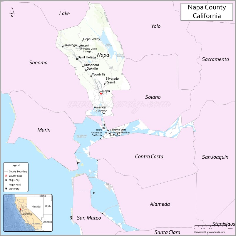
About Napa County Map, California: The map showing the county boundary, county seat, major cities, highways, water bodies and neighbouring counties.
Most Viewed Links
About Napa County, California
Napa County is a county located in Northern California's wine country region. Its county seat is the city of Napa. The county is famous for its many wineries and vineyards, which attract millions of tourists each year. The county has a population of around 140,000 people, according to the latest estimates.Napa County was established on 1850.
Some of the other notable cities and towns in Napa County include Yountville, St. Helena, Calistoga, and American Canyon. In addition to its wine industry, the county is also home to many parks, hiking trails, and other outdoor recreation areas, including the Bothe-Napa Valley State Park, the Skyline Wilderness Park, and Lake Berryessa.
Napa County has a rich history, dating back to its establishment as a county in 1850. The county was named after the Napa River, which flows through it. Over the years, the county has experienced numerous earthquakes and wildfires, but it has always bounced back, thanks to the resilience of its residents and the strength of its local economy.
Facts about Napa County, California
| Country | United States |
| State | California |
| Region | Northern California (North Bay / Wine Country) |
| County Seat | Napa |
| Named After | Napa Valley (name of Native American origin) |
| Established | 1850 |
| Organized | 1850 |
| Coordinates | 38.5025° N, 122.2654° W |
| Total Area | 789 sq mi |
| Land Area | 754 sq mi |
| Water Area | 35 sq mi |
| Population (2020) | 138,019 |
| Population Rank | Mid-sized county in California |
| Major Cities | Napa, American Canyon, Yountville |
| Main Industries | Wine Production, Tourism, Agriculture, Hospitality |
| Major Airport | Napa County Airport |
| Time Zone | Pacific Time (UTC−08:00) |
| Known For | Napa Valley wine region, Vineyards, Culinary tourism, Scenic landscapes |
| Website | https://www.countyofnapa.org |
Ctities and Towns in Napa County County
| City Name | Type | Population (2020) | Pop. Density | Area | Incorporated |
|---|---|---|---|---|---|
| American Canyon | City | 21,837 | 3,585.7/sq mi (1,384.5/km2) | 6.09 sq mi (15.8 km2) | January 1, 1992 |
| Calistoga | City | 5,228 | 2,026.4/sq mi (782.4/km2) | 2.58 sq mi (6.7 km2) | January 6, 1886 |
| Napa | City | 79,246 | 4,390.4/sq mi (1,695.1/km2) | 18.05 sq mi (46.7 km2) | March 23, 1872 |
| St. Helena | City | 5,430 | 1,094.8/sq mi (422.7/km2) | 4.96 sq mi (12.8 km2) | March 24, 1876 |
| Yountville | Town | 3,436 | 2,306.0/sq mi (890.4/km2) | 1.49 sq mi (3.9 km2) | February 4, 1965 |
Places to Visit in Napa County County
Top places to visit in Napa includes Castello di Amorosa, Connolly Ranch Education Center, Alston Park, Napa Valley Balloons, Inc, Westwood Hills Park, O'Brien, Estate Winery.
Highways in Napa County
State Route 12, State Route 29, State Route 121, State Route 128, State Route 221.
Nearest Airports
Nearest airport of Napa is Napa County Airport.
- Alameda County Map
- Alpine County Map
- Amador County Map
- Butte County Map
- Calaveras County Map
- Colusa County Map
- Contra Costa County Map
- Del Norte County Map
- El Dorado County Map
- Fresno County Map
- Glenn County Map
- Humboldt County Map
- Imperial County Map
- Inyo County Map
- Kern County Map
- Kings County Map
- Lake County Map
- Lassen County Map
- Los Angeles County Map
- Madera County Map
- Marin County Map
- Mariposa County Map
- Mendocino County Map
- Merced County Map
- Modoc County Map
- Mono County Map
- Monterey County Map
- Napa County Map
- Nevada County Map
- Orange County Map
- Placer County Map
- Plumas County Map
- Riverside County Map
- Sacramento County Map
- San Benito County Map
- San Bernardino County Map
- San Diego County Map
- San Francisco County Map
- San Joaquin County Map
- San Luis Obispo County Map
- San Mateo County Map
- Santa Barbara County Map
- Santa Clara County Map
- Santa Cruz County Map
- Shasta County Map
- Sierra County Map
- Siskiyou County Map
- Solano County Map
- Sonoma County Map
- Stanislaus County Map
- Sutter County Map
- Tehama County Map
- Trinity County Map
- Tulare County Map
- Tuolumne County Map
- Ventura County Map
- Yolo County Map
- Yuba County Map
- Alabama Counties
- Alaska boroughs
- Arizona Counties
- Arkansas Counties
- California County Map
- Colorado Counties
- Connecticut Counties
- Delaware Counties
- Florida County Map
- Georgia County Map
- Hawaii Counties
- Idaho Counties
- Illinois Counties
- Indiana Counties
- Iowa Counties
- Kansas Counties
- Kentucky Counties
- Louisiana Counties
- Maine Counties
- Maryland Counties
- Massachusetts Counties
- Michigan County Map
- Minnesota Counties
- Mississippi Counties
- Missouri Counties
- Montana Counties
- Nebraska Counties
- Nevada Counties
- New York Counties
- New Hampshire Counties
- New Jersey Counties
- New Mexico Counties
- North Carolina Counties
- North Dakota Counties
- Ohio County Map
- Oklahoma Counties
- Oregon Counties
- Pennsylvania Counties
- Rhode Island Counties
- South Carolina Counties
- South Dakota Counties
- Map of Tennessee
- Texas County Map
- Utah Counties
- Vermont Counties
- Virginia Counties
- Washington Counties
- West Virginia Counties
- Wisconsin Counties
- Wyoming Counties